Selwyn is a village in the Selwyn District of Canterbury, New Zealand. It was laid out in the 1860s for a population of 2,000 people, but it currently has very few houses.

The Ōtira River is located in the central South Island of New Zealand. It rises on the slopes of Mount Rolleston in the Southern Alps, and flows north for 20 kilometres (12 mi), passing through the town of Otira before joining the Taramakau River. The Taramakau's outflow is into the Tasman Sea, 12 kilometres (7.5 mi) south of Greymouth.

Selwyn District is a predominantly rural district in central Canterbury, on the east coast of New Zealand's South Island. It is named after the Selwyn River / Waikirikiri, which is in turn named after Bishop George Selwyn, the first Anglican bishop of New Zealand who, in 1843 and 1844, travelled the length of the country by horse, foot, boat and canoe, leaving in his wake a sprinkling of locations that now bear his name.

Rolleston is the seat and largest town in the Selwyn District, in the Canterbury region of New Zealand's South Island. It is located on the Canterbury Plains 22 kilometres (14 mi) south-west of Christchurch, and is part of the wider Christchurch metropolitan area.

The Main South Line, sometimes referred to as part of the South Island Main Trunk Railway, is a railway line that runs north and south from Lyttelton in New Zealand through Christchurch and along the east coast of the South Island to Invercargill via Dunedin. It is one of the most important railway lines in New Zealand and was one of the first to be built, with construction commencing in the 1860s. At Christchurch, it connects with the Main North Line to Picton, the other part of the South Island Main Trunk.

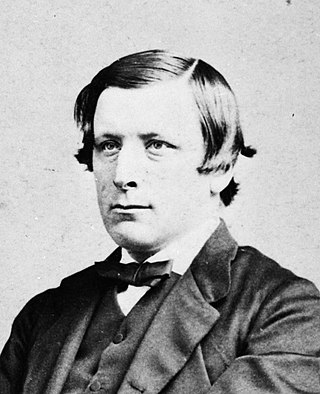
William Rolleston was a New Zealand politician, public administrator, educationalist and Canterbury provincial superintendent.

Francis Joseph Rolleston was a New Zealand politician of the Reform Party.
Riccarton is a former New Zealand parliamentary electorate. It existed from 1893 to 1978, and was represented by eight Members of Parliament.

The Comet River is a river in Central Queensland, Australia.
The Crow River is a river in Arthur's Pass National Park, Canterbury, New Zealand. It arises near Mount Rolleston and flows south into the Waimakariri River.
John Christopher Rolleston was a Reform Party Member of Parliament in New Zealand.
Ellesmere was a parliamentary electorate in the Canterbury region of New Zealand. It existed for two periods between 1861 and 1928 and was represented by six Members of Parliament.

Mount Rolleston (2,271 m) is a prominent peak in Arthur's Pass National Park in the South Island of New Zealand. It was named by the surveyor Arthur Dudley Dobson in 1864, who observed the peak while searching for a route through the Southern Alps to the West Coast gold fields. The name honours the then Superintendent of the Canterbury Province, William Rolleston.

The Rolleston Statue is a white marble statue situated outside Canterbury Museum on Rolleston Avenue in Christchurch, New Zealand. It commemorates William Rolleston, who was Superintendent of the Canterbury Province from 1868 until 1877.
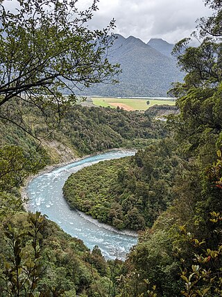
The Taipo River is a river of the central West Coast Region of New Zealand's South Island. It flows north from its sources west of Mount Rolleston, fed by the waters of several mountain streams. After some 15 kilometres it turns northeast to flow past the Bald Range before reaching the valley of the Taramakau River into which it flows 35 kilometres east of Hokitika.
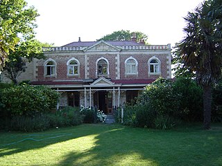
Linwood House was built as the homestead for Joseph Brittan, who, as surgeon, newspaper editor and provincial councillor, was one of the dominant figures in early Christchurch, New Zealand. The suburb of Linwood was named after Brittan's farm and homestead. Brittan's daughter Mary married William Rolleston, and they lived at Linwood House following Joseph Brittan's death. During that time, Rolleston was the 4th Superintendent of the Canterbury Province, and Linwood House served for many important political and public functions.
The 1868 Avon by-election was a by-election held on 8 June during the 4th New Zealand Parliament in the Christchurch electorate of Avon.

Gloucester Street is a major urban street in central Christchurch in the South Island of New Zealand. It runs for approximately 4.9 kilometres (3.0 mi) from a junction with Rolleston Avenue at its western end, directly opposite Christ's College, to the suburbs of Linwood and Avonside in the east. For the majority of its length it runs due west-east, with the section from the central city's eastern edge to Linwood veering to the northeast.


