
Caledon is a town in the Regional Municipality of Peel in the Greater Toronto Area of Ontario, Canada. The name comes from a shortened form of Caledonia, the Roman name for what is now Scotland. Caledon is primarily rural with a number of hamlets and small villages, but also contains the larger community of Bolton in its southeastern quadrant, adjacent to York Region. Some spillover urbanization also occurs in the south bordering the City of Brampton.
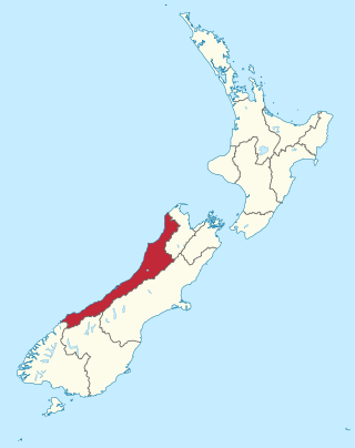
The West Coast is a region of New Zealand on the west coast of the South Island. It is administered by the West Coast Regional Council, and is known co-officially as Te Tai Poutini. It comprises the territorial authorities of Buller District, Grey District and Westland District. The principal towns are Westport, Greymouth and Hokitika. The region, one of the more remote areas of the country, is also the most sparsely populated. With a population of just 32,900 people, the West Coast is the least populous region in New Zealand. The population in the region grew by 0.4% over the year to July 2023.

Raes Junction is a small settlement in New Zealand, located at the intersection of State Highways 8 and 90, in the lower South Island. The highways which meet at the junction are the main routes to the Clutha valley for travellers from Dunedin and Invercargill respectively.

Tiki Wiki CMS Groupware or simply Tiki, originally known as TikiWiki, is a free and open source Wiki-based content management system and online office suite written primarily in PHP and distributed under the GNU Lesser General Public License (LGPL-2.1-only) license. In addition to enabling websites and portals on the internet and on intranets and extranets, Tiki contains a number of collaboration features allowing it to operate as a Geospatial Content Management System (GeoCMS) and Groupware web application.

The Haast River / Awarua is a river on the West Coast of the South Island of New Zealand. The Māori name for the river is Awarua. It drains the western watershed of the Haast Pass. The Haast River is 100 kilometres (62 mi) in length, and enters the Tasman Sea near Haast township. The river's main tributary is the Landsborough River.

The Kawarau River is a river in the South Island of New Zealand. It drains Lake Wakatipu in northwestern Otago via the lake's Frankton Arm. The river flows generally eastwards for about 60 kilometres (37 mi) and passes through the steep Kawarau Gorge until it joins Lake Dunstan near Cromwell. Before the construction of the Clyde High Dam, the Kawarau joined the Clutha River / Mata-Au in a spectacular confluence at Cromwell. The Shotover River enters the Kawarau from the north; the Nevis River enters it from the south. With many rapids and strong currents, the river can be dangerous and has claimed many lives. It is popular for bungy jumping and kayaking.
Inch Clutha is a large, flat island sitting in the delta between the Matau (northern) and Koau (southern) branches of the Clutha River, downstream from the town of Balclutha in the South Island of New Zealand. Approximately 10 kilometres (6 mi) long and 3 kilometres (2 mi) wide, the fertile but flood-prone land of the island is extensively farmed. The island was formed in 1878 after a massive flood changed the course of the Clutha, which had formerly reached the ocean 4 km to the south at Port Molyneux.

The Waiau River is the largest river in the Southland region of New Zealand. 'Waiau' translates to 'River of Swirling Currents'. It is the outflow of Lake Te Anau, flowing from it into Lake Manapouri 10 kilometres (6 mi) to the south, and from there flows south for 70 kilometres (43 mi) before reaching the Foveaux Strait 8 kilometres (5 mi) south of Tuatapere. It also takes water from Lake Monowai.
Otanomomo is a locality in the South Otago region of New Zealand's South Island. It is situated on the banks of the Koau Branch of the Clutha River, roughly six kilometres south of Balclutha. Nearby settlements include Finegand to the north, Paretai, Puerua, and Romahapa to the south, and Waitepeka to the west.
Whitebait is a collective term for the immature fry of fish, typically between 25 and 50 millimetres long. Such young fish often travel together in schools along coasts, and move into estuaries and sometimes up rivers where they can be easily caught using fine-meshed fishing nets. Whitebaiting is the activity of catching whitebait.
The Maori River is a river of the West Coast Region of New Zealand's South Island. It flows from several sources in the Mataketake Range east of Haast, passing through the small Tawharekiri Lakes before becoming a tributary of the Waita River, which flows into the Tasman Sea 15 kilometres north of Haast.

The Fraternal Order of Moai is a fraternal order and social club founded in 2005 by Matt "Kuku Ahu" Thatcher, Jim "Chisel Slinger" Robinson and Joel "Cowtown Kahuna" Gunn. The Order uses the Moai statues of Rapa Nui as a theme. An initial goal of the group was to preserve the history of and artifacts from the closed Kahiki Supper Club in Columbus, Ohio. Since then it has grown into "a serious group of tiki aficionados" with activity all over the United States. Some describe the group as "a cult within a cult" when discussing the modern Tiki revival.
Daniell Peninsula is the large peninsula between Cape Daniell and Cape Jones on the coast of Victoria Land, Antarctica. It is an elongated basalt dome similar to Adare Peninsula and Hallett Peninsula and rises to 2,000 metres (6,600 ft). It is partly separated from the Victory Mountains by Whitehall Glacier, which is afloat in its lower reaches, but is joined to these mountains by the higher land in the vicinity of Mount Prior. It was named by the New Zealand Geological Survey Antarctic Expedition (NZGSAE), 1957–58, after Cape Daniell, and by analogy with the Adare and Hallett peninsulas.

Mandible Cirque is a cirque indenting the coast of Daniell Peninsula 8 km (5.0 mi) west-south-west of Cape Phillips, in Victoria Land, Antarctica. It was named in 1966 by the New Zealand Antarctic Place-Names Committee for its appearance in plan and oblique views suggestive of a mandible.
Elaine Bay is a bay located in Pelorus Sound / Te Hoiere, within the Marlborough Sounds at the north end of the South Island of New Zealand. Elaine Bay is in the Tawhitinui Reach, which includes other bays such as Tennyson Inlet, Fitzroy Bay and Hallum Cove. The bay is accessed by the Elaine Bay Road, which connects with the Croisilles-French Pass Road at the top of the ridge.

Pounamu is a term for several types of hard and durable stone found in the South Island of New Zealand. They are highly valued in New Zealand, and carvings made from pounamu play an important role in Māori culture.

Punakaiki Marine Reserve is a marine reserve administered by the Department of Conservation. The reserve includes the area of sea surrounding the pancake rocks and blowholes at Dolomite Point, at Punakaiki on the West Coast Region of New Zealand's South Island. It also includes most of the coastline on the western edge of Paparoa National Park.

The Copland Track is a tramping track in the south Westland area of New Zealand's South Island, well known for the naturally-occurring hot springs at Welcome Flat along its route. The main track is approximately 25 kilometres (16 mi) long one-way from the trailhead at State Highway 6 to the track's inland end at the Douglas Rock Hut, and is usually completed in 2 to 4 days depending on whether the full distance is walked, with many opting to walk only as far as Welcome Flat. The track is the western portion of a longer path which historically connected the West Coast to Mount Cook Village via Copland Pass, however erosion and the retreat of the Hooker Glacier has led to the eastern side of this route becoming increasingly dangerous to traverse.

The historic Haast to Paringa Cattle Track is a trail through South Westland, New Zealand, constructed in 1875 to allow farmers in the Landsborough and Cascade Valley area to drive their cattle on an annual two-week journey to the sale yards in Whataroa. It was constructed as an inland loop to bypass the precipitous cliffs at Knights Point. For 90 years it was the only land access to the settlements of Haast and Jackson Bay, but the last mob of cattle was driven in 1961, and the construction of a highway connecting Paringa to Haast Pass in 1965 made it redundant. After falling into disuse, the cattle track was converted into a 33-kilometre (21 mi), three-day tramping track, opening in 1981. The track and its three huts are maintained by the New Zealand Department of Conservation.

