Nelson Lakes National Park is in the South Island of New Zealand, at the northern end of the Southern Alps. It was created in 1956. The park contains beech forests, multiple lakes, snow-covered mountains and valleys created by glaciers during the ice ages.

Kahurangi National Park in the northwest of the South Island of New Zealand is the second largest of the thirteen national parks of New Zealand. It was gazetted in 1996 and covers 5,193 km2 (2,005 sq mi), ranging from the Buller River near Murchison in the south, to the base of Farewell Spit in Golden Bay in the north. The park has no single dominant landform, but includes an unusually wide variety of landscapes, including mountain ranges, rivers, gorges, raised peneplains and karst features such as caves and arches. Many of the landforms within the park are considered to be nationally or internationally significant.

Arthur's Pass National Park is located in the South Island of New Zealand and covers 1,185 km2 of mostly mountainous terrain. Adjacent to it lies Craigieburn Forest Park. The park is administered by the Department of Conservation.

The Kawarau River is a river in the South Island of New Zealand. It drains Lake Wakatipu in northwestern Otago via the lake's Frankton Arm. The river flows generally eastwards for about 60 kilometres (37 mi) and passes through the steep Kawarau Gorge until it joins Lake Dunstan near Cromwell. Before the construction of the Clyde High Dam, the Kawarau joined the Clutha River / Mata-Au in a spectacular confluence at Cromwell. The Shotover River enters the Kawarau from the north; the Nevis River enters it from the south. With many rapids and strong currents, the river can be dangerous and has claimed many lives. It is popular for bungy jumping and kayaking.

The Heaphy Track is a popular tramping and mountain biking track in the north west of the South Island of New Zealand. It is located within the Kahurangi National Park and classified as one of New Zealand's ten Great Walks by the Department of Conservation. Named after Charles Heaphy, the track is 78.4 kilometres (48.7 mi) long and is usually walked in four or five days. The track is open for shared use with mountain bikers in the winter season from 1 May to 30 September each year. The southern end of the track is at Kōhaihai, north of Karamea on the northern West Coast, and the northern end is in the upper valley of the Aorere River, Golden Bay.
The Milford Track is a hiking route in New Zealand, located amidst mountains and temperate rain forest in Fiordland National Park in the southwest of the South Island. The 53.5 km (33.2 mi) hike starts at Glade Wharf at the head of Lake Te Anau and finishes in Milford Sound at Sandfly Point, traversing rainforests, wetlands, and an alpine pass.
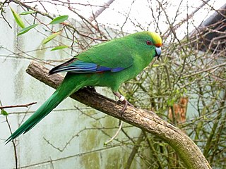
Malherbe's parakeet is a small parrot endemic to New Zealand, where it is known as the orange-fronted parakeet or orange-fronted kākāriki. In the rest of the world it is called Malherbe's parakeet, as when it was recognised as a species, the name "orange-fronted parakeet" was already used for Eupsittula canicularis, a Central American species. Restricted to a few valleys in the South Island and four offshore islands, its population declined to around 200 in the 1990s, and it is considered critically endangered by the IUCN.

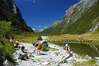
The Kepler Track is a 60 km (37 mi) circular hiking track which travels through the landscape of the South Island of New Zealand and is situated near the town of Te Anau. The track passes through many landscapes of the Fiordland National Park such as rocky mountain ridges, tall mossy forests, lake shores, deep gorges, rare wetlands and rivers. Like the mountains it traverses, the track is named after Johannes Kepler. The track is one of the New Zealand Great Walks and is administered by the Department of Conservation (DOC).

Secretary Island is an island in southwestern New Zealand, lying entirely within Fiordland National Park. Roughly triangular in shape, it lies between Doubtful Sound / Patea in the south and Te Awa-o-Tū / Thompson Sound in the north, with its west coast facing the Tasman Sea. To the east of the island, Pendulo Reach connects Te Awa-o-Tū / Thompson Sound with Doubtful Sound / Patea. Steeply sloped, the entirely bush-clad island rises to a chain of several peaks higher than 1000 metres. The highest of these is the 1,196-metre (3,924 ft) Mount Grono, the highest peak in the main New Zealand chain not located in the North or South Island. The island also contains three lakes. The largest, Secretary Lake, over 600 metres (2,000 ft) long, is located beneath Mount Grono at an altitude of 550 metres (1,800 ft).

The Whataroa River, sometimes the Wataroa River, is a river in the southern West Coast region of New Zealand's South Island. Its source is in the Southern Alps and it flows north and northwest, passing the township of Whataroa on the eastern side before reaching the Tasman Sea just south of Abut Head. The river is fed by many tributaries, such as the Perth River, and is crossed by State Highway 6 on its route between Whataroa and Te Taho.

Whataroa is a small township in southern Westland on the West Coast of New Zealand's South Island. It is located on alluvial flats to the west of the Whataroa River. State Highway 6 passes through Whataroa on its route from Ross to Franz Josef / Waiau. Hari Hari is 31 kilometres (19 mi) to the north-east, and Franz Josef is 32 km to the south-west.
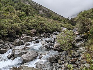
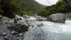
The Deception River is a river in New Zealand. It is a tributary of the West Coast's Ōtira River, flowing generally north for 17 kilometres (11 mi) from its source on the slopes of Mount Franklin. It passes close to Goat Pass, which gives access to the Mingha River. Almost the entire length of the river is within the Arthur's Pass National Park.

The RangitataGorge is a gorge located in the Canterbury High Country in the South Island of New Zealand. The narrow gorge links the headwaters of the Rangitata River with the fertile Canterbury Plains. The Rangitata gorge is commercially rafted by a local company. It is also a popular river for visiting kayakers, fishermen and adventurist locals in jet boats. The gorge is a class IV to V+ depending on the flow of the river and home to the notable rapids including Rooster's Tail, Pencil Sharpener, The Pinch, Pigs Trough and Hells Gate.

The Old Ghost Road is a mountain bike and tramping trail part-funded as one of the projects of the New Zealand Cycle Trail (NZCT) system in the Buller District of New Zealand. Of all NZCT projects, it is the technically most difficult one to ride and is rated "advanced". The highest point of the trail is at 1,280 metres (4,200 ft).

The Paparoa Track is a 55.7 km (34.6 mi) shared hiking and mountain biking track located in Paparoa National Park in the South Island of New Zealand. The track was created as a memorial for the 29 miners who lost their lives in the Pike River Mine disaster. The track is the tenth Great Walk to be created and has been fully open since 1 March 2020. It was the first addition to the Great Walks in 25 years.
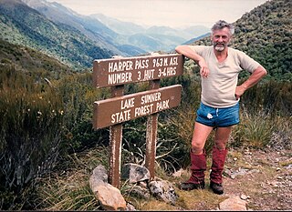
Harper Pass, previously known as Hurunui Pass or sometimes Taramakau Pass, is an alpine pass between Canterbury and the West Coast in New Zealand. It was the most important crossing for Māori to obtain pounamu. The first European crossed the pass in 1857 and the leader of the second party later that year, Leonard Harper, gave the pass its current name. It was of some interest to the settlers as the West Coast was part of Canterbury Province and it remained the only feasible route for some years. When the West Coast Gold Rush started in 1864, it became a heavily used crossing and remained so until October 1865, when a dray road over Arthur's Pass opened. The Arthur's Pass route was upgraded in March 1866 to coach traffic standard, and the much less direct route over Harper Pass fell out of use. It was restored in the 1930s as a tramping route and the Harper Pass Track, a four or five-day tramp, is today part of Te Araroa over its entire length.

Lewis Vernon Sanson is the former director of the New Zealand Department of Conservation.

The Copland Track is a tramping track in the south Westland area of New Zealand's South Island, well known for the naturally-occurring hot springs at Welcome Flat along its route. The main track is approximately 25 kilometres (16 mi) long one-way from the trailhead at State Highway 6 to the track's inland end at the Douglas Rock Hut, and is usually completed in 2 to 4 days depending on whether the full distance is walked, with many opting to walk only as far as Welcome Flat. The track is the western portion of a longer path which historically connected the West Coast to Mount Cook Village via Copland Pass, however erosion and the retreat of the Hooker Glacier has led to the eastern side of this route becoming increasingly dangerous to traverse.

The Wangapeka Track is a tramping track in the north-west of the South Island of New Zealand. It is one of the main tramping tracks in the Kahurangi National Park, a protected area managed by the Department of Conservation. The route traverses the southern end of the park, from the historic Wangapeka goldfields area west of Tapawera, to the coastal plains of the West Coast at Little Wanganui. The route is 59 km (37 mi) long, and crosses the Wangapeka and Little Wanganui saddles, each over 1,000 m (3,300 ft) in elevation. The track passes through the valleys of the Wangapeka River, Karamea River, Taipō River and Little Wanganui River. The majority of the track is in river valleys and under forest cover, with small sections in tussock land at Stag Flat and the Little Wanganui Saddle. It typically takes walkers 4–6 days to complete the route.

The historic Haast to Paringa Cattle Track is a trail through South Westland, New Zealand, constructed in 1875 to allow farmers in the Landsborough and Cascade Valley area to drive their cattle on an annual two-week journey to the sale yards in Whataroa. It was constructed as an inland loop to bypass the precipitous cliffs at Knights Point. For 90 years it was the only land access to the settlements of Haast and Jackson Bay, but the last mob of cattle was driven in 1961, and the construction of a highway connecting Paringa to Haast Pass in 1965 made it redundant. After falling into disuse, the cattle track was converted into a 33-kilometre (21 mi), three-day tramping track, opening in 1981. The track and its three huts are maintained by the New Zealand Department of Conservation.