
Greater Wellington, also known as the Wellington Region, is a non-unitary region of New Zealand that occupies the southernmost part of the North Island. The region covers an area of 8,049 square kilometres (3,108 sq mi), and has a population of 550,600.

Gisborne is a city in northeastern New Zealand and the largest settlement in the Gisborne District. It has a population of 38,800. Gisborne District Council has its headquarters in the central city.

The Kaimai Range is a mountain range in the North Island of New Zealand. It is part of a series of ranges, with the Coromandel Range to the north and the Mamaku Ranges to the south. The Kaimai Range separates the Waikato in the west from the Bay of Plenty in the east.

The Clutha River is the second longest river in New Zealand and the longest in the South Island. It flows south-southeast 338 kilometres (210 mi) through Central and South Otago from Lake Wānaka in the Southern Alps to the Pacific Ocean, 75 kilometres (47 mi) south west of Dunedin. Gold is in abundance in the Clutha River and its surrounding areas. It is the highest volume river in New Zealand, and has a discharging mean flow of 614 cubic metres per second (21,700 cu ft/s).

Manawatū-Whanganui is a region in the lower half of the North Island of New Zealand, whose main population centres are the cities of Palmerston North and Whanganui. It is administered by the Manawatū-Whanganui Regional Council, which operates under the name Horizons Regional Council.

Haast is a small town in the Westland District on the West Coast of New Zealand's South Island. The township is beside the Haast River, 3 kilometres (2 mi) south of Haast Junction, on State Highway 6. The Haast region is in Te Wahipounamu – The South West New Zealand World Heritage, a UNESCO World Heritage Site designated in 1990.

Auckland is one of the 16 regions of New Zealand, which takes its name from the eponymous urban area. The region encompasses the Auckland metropolitan area, smaller towns, rural areas, and the islands of the Hauraki Gulf. Containing 34 percent of the nation's residents, it has by far the largest population and economy of any region of New Zealand, but the second-smallest land area.

Paparoa National Park is on the west coast of the South Island of New Zealand. The park was established in 1987 and encompasses 430 km2 (170 sq mi). The park ranges from or near the coastline to the peaks of the Paparoa Range. A separate section of the park lies to the north and is centred at Ananui Creek. The park protects a limestone karst area. The park contains several caves, of which Metro Cave / Te Ananui Cave is a commercial tourist attraction. The majority of the park is forested with a wide variety of vegetation. The park was the site of the 1995 Cave Creek disaster where fourteen people died as a result of the collapse of a scenic viewing platform.

Waikanae is a town on the Kāpiti Coast, 60 km (37 mi) north of the Wellington, New Zealand. The name is a Māori word meaning "waters" (wai) "of the grey mullet".

The Taieri River is the fourth-longest river in New Zealand and is in Otago in the South Island. Rising in the Lammerlaw Range, it initially flows north, then east around the Rock and Pillar range before turning southeast, reaching the sea 30 kilometres (19 mi) south of Dunedin.

The Maniototo Plain, usually simply known as The Maniototo, is an elevated inland region in Otago, New Zealand. The region roughly surrounds the upper reaches of the Taieri River and the Manuherikia River. It is bounded by the Kakanui Range to the north and the Rock and Pillar Range to the southeast. It has a harsh, dry climate, ranging from over 30 °C in mid-summer to -15 °C in mid-winter.

The Kaikōura Ranges are two parallel ranges of mountains located in the Canterbury Region in the northeast of the South Island of New Zealand. The two ranges are visible from a great distance, including from the southern coast of the North Island.
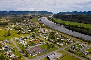
Dobson is a small town on the banks of the Grey River in the South Island of New Zealand. It is 10 kilometres (6 mi) east from the river's mouth at Greymouth. The settlement of Taylorville is across the river from Dobson, but no bridge directly connects the two. State Highway 7 passes through Dobson.
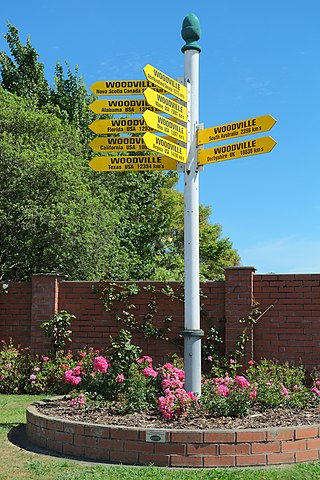
Woodville, previously known as The Junction, is a small town in the southern North Island of New Zealand, 75 km north of Masterton and 25 km east of Palmerston North. The 2013 census showed that 1401 people reside in Woodville.

Waimakariri District is a local government district, located in the Canterbury Region of New Zealand's South Island. It is named after the Waimakariri River, which forms the district's southern boundary, separating it from Christchurch City and the Selwyn District. It is bounded in the north by the Hurunui District and in the east by the Pacific Ocean.

Tapu is a locality on the western side of the Coromandel Peninsula of New Zealand. State Highway 25 runs through it. Coromandel is 35 km to the north, and Thames is 19 km to the south. The Tapu River flows from the Coromandel Range past the settlement and into the Firth of Thames to the west.

Ahaura is a town in the West Coast region of New Zealand's South Island, sited where the Ahaura River flows into the Grey River. State Highway 7 and the Stillwater–Ngākawau railway line pass through the town. Greymouth is 34 kilometres (21 mi) to the south-west, and Reefton is 44 kilometres (27 mi) to the north-east.

The Waitangitāhuna River are two rivers in the West Coast region of New Zealand's South Island. It was a single river until an avulsion in March 1967, when it became two rivers. Since then, the southern portion of the river has flowed into Lake Wahapo, while the northern section discharges into the Tasman Sea north of Ōkārito Lagoon.
Kaweka Forest Park is in the Hawke's Bay region of New Zealand, adjacent to Kaimanawa Forest Park. This region of the central North Island contains large tracts of pine plantations, some of them also within the park, and as a consequence, invasive wilding conifers are present throughout the 594 km2 (229 sq mi) park.

The Lammerlaw Range is in the Otago region of New Zealand. It is an important watershed, and the source of many of the tributaries in the Taieri and lower Clutha River systems. The origins of the placename are Scottish. Windfarms have been sited in the area. The area includes distinctive geology including ribbon fens and peat habitats. The Lammerlaw and adjacent to the northeast Lammermoor Ranges also include tussock grasslands. Parts of the ranges are in Te Papanui Conservation Park. The endangered Eldon's galaxias is found in the range.


