Related Research Articles
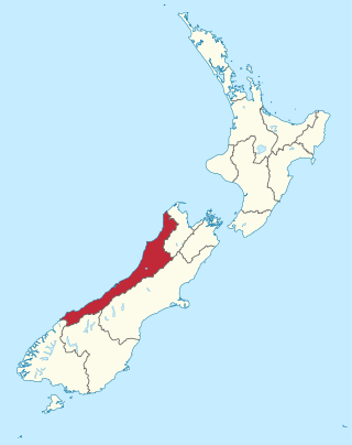
The West Coast is a region of New Zealand on the west coast of the South Island. It is administered by the West Coast Regional Council, and is known co-officially as Te Tai Poutini. It comprises the territorial authorities of Buller District, Grey District and Westland District. The principal towns are Westport, Greymouth and Hokitika. The region, one of the more remote areas of the country, is also the most sparsely populated. With a population of just 32,900 people, the West Coast is the least populous region in New Zealand. The population in the region grew by 0.4% over the year to July 2023.

The Witwatersrand is a 56-kilometre-long (35 mi), north-facing scarp in South Africa. It consists of a hard, erosion-resistant quartzite metamorphic rock, over which several north-flowing rivers form waterfalls, which account for the name Witwatersrand, meaning "white water ridge" in Afrikaans. This east-west-running scarp can be traced with only one short gap, from Bedfordview in the east, through Johannesburg and Roodepoort, to Krugersdorp in the west.

Hokitika is a town in the West Coast region of New Zealand's South Island, 40 kilometres (25 mi) south of Greymouth, and close to the mouth of the Hokitika River. It is the seat and largest town in the Westland District. The town's estimated population is 3,120 as of June 2023.

Ōkārito Lagoon is a coastal lagoon on the West Coast of New Zealand's South Island. It is located 130 kilometres (81 mi) south of Hokitika, and covers an area of about 3,240 hectares (12.5 sq mi), making it the largest unmodified coastal wetland in New Zealand. It preserves a sequence of vegetation types from mature rimu forest through mānuka scrub to brackish water that has been lost in much of the rest of the West Coast. The settlement of Ōkārito is at the southern end of the lagoon.

Ross is a small town located in the Westland District on the West Coast of New Zealand's South Island, 27 kilometres (17 mi) south-west of Hokitika and 46 kilometres (29 mi) north-east of Hari Hari by road.

Westland District is a territorial authority district on the West Coast of New Zealand's South Island. It is administered by the Westland District Council. The district's population is 8,940.

Oakley stone is the trade name of a building stone that occurs in the mountains of southern Idaho in the western United States. It is more properly known as Rocky Mountain quartzite or Idaho quartzite, a metamorphic rock. The stone is quarried south of the city of Oakley in Cassia County, northeast of the three-state border with Nevada and Utah. The quarries are located on the west slope of Middle Mountain in the Albion Mountains, northwest of the City of Rocks National Reserve.

The Hokitika River is in the West Coast of the South Island of New Zealand. It is about 64 kilometers (40 mi) long, beginning in the Southern Alps, emerging from the narrow Hokitika Gorge after merging with the Whitcombe River, and flowing into the Tasman Sea just south of the town of Hokitika. The river then feeds into the offshore Hokitika Canyon, which merges with the Cook Canyon to form the Cook Channel. The canyons extend to about 650 km (400 mi) and are important spawning areas for hoki, hake and orange roughy.
Blue Spur is a locality in Otago, New Zealand.
Kokatahi is a locality on the West Coast of New Zealand. Hokitika is about 15 km to the north-west. The Kokatahi River flows through the area and into the Hokitika River to the north-west.

The Arnold River is a river on the West Coast of New Zealand's South Island. It is the outflow of Lake Brunner, which it links with the Grey River at Stillwater. The Arnold River flows northwest for 20 kilometres (12 mi), joining the Grey immediately above the town of Brunner, some 15 kilometres (9 mi) from the Tasman Sea. It is a popular spot for whitewater kayaking and trout fishing.

Spruce Mountain, located in eastern West Virginia, is the highest ridge of the Allegheny Mountains. The whale-backed ridge extends for only 16 miles (26 km) from northeast to southwest, but several of its peaks exceed 4,500 feet (1,400 m) in elevation. The summit, Spruce Knob, is the highest Allegheny Mountain point both in the state and the entire range, which spans four states.

Shantytown Heritage Park, usually known as Shantytown, is a tourist attraction in the West Coast Region of the South Island of New Zealand. Located 10 kilometres (6.2 mi) south of Greymouth, the Heritage Park opened in 1971 and consists of 30 re-created historic buildings making up a 19th-century gold-mining town. The town is surrounded by native forest, and is one of the region's most popular attractions.

The Marlboro Mountains, sometimes Marlborough Mountains, are a group of hogbacked mountains arranged in a 25-mile-long (40 km) ridge extending from Newburgh, New York, to just south of Kingston, New York. Considered to be part of the Ridge and Valley Appalachians, the mountains, which reach elevations over 1,100 feet, form an imposing geologic barrier just west of the Hudson River. They subdivide the relatively flat Hudson River Valley to create the Wallkill Valley further west. Rising abruptly on their eastern flanks, the Marlboro Mountains are known for their sweeping views of the region.

Perpendicular Point is a small headland on the West Coast of New Zealand's South Island, overlooking the Tasman Sea. It lies about 40 km south-south-west of Cape Foulwind, close to the small community of Te Miko. Perpendicular Point was known as Te Miko to Māori. A notorious obstacle to coastal travel, the cliffs had ladders built from rātā vine and harakeke, later replaced by chains and rungs, until a reliable inland road was built in the 1860s.

Westland County, also known as County of Westland, was a local government area on the West Coast of New Zealand's South Island. It existed from 1868 to 1873, and then from 1876 until 1989. In its first incarnation, it constituted the government for the area that was split from the Canterbury Province, with the West Coast Gold Rush having given the impetus for that split. It had the same administrative powers as a provincial council, but the legislative power rested with Parliament in Wellington. The first Westland County was the predecessor to Westland Province.

The Hokitika Borough was the borough council covering the urban part of the town of Hokitika, New Zealand between 1867 and 1989, when Hokitika Borough and Westland County merged to form Westland District.

The West Coast Wilderness Trail has been funded as one of the projects of the New Zealand Cycle Trail. Once complete, the 139 kilometres (86 mi) track will connect Greymouth in the north with Ross in the south.

Hokitika Museum is a museum in Hokitika on the West Coast of the South Island in New Zealand, and is the West Coast's largest museum and archive. It is housed in the historic Hokitika Carnegie Library building. Exhibitions include information about the gold rush and the unique West Coast stone pounamu (greenstone) and its value to Māori. The museum also holds a significant photographic collection. Seismic strengthening requirements closed the museum in September 2019. According to the Westland District Council Web site as of December 2021 the museum had not yet reopened.

Rimu, originally known as Upper Woodstock, is a small town in the Westland District of New Zealand's South Island.
References
- ↑ Blue Spur States Archived 8 July 2011 at the Wayback Machine
- ↑ Red Flag Archived 9 September 2007 at the Wayback Machine