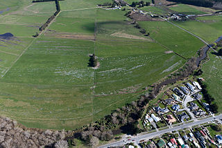
The locality began about 1865 as one of the main alluvial gold fields of the West Coast gold rush.[5][6] The Hokitika & Kanieri Tramway laid with wooden rails was established from Hokitika by 1868, with cars drawn by horses.[7] A road followed by 1873.[8]
Kaniere often seen written Kanieri, official spelling of the town is Kaniere [9]
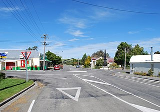
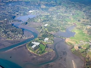
Locality on the Hokitika River, 5km southeast of Hokitika. Kaniere Survey District.
History/Origin/Meaning:
Reeds[10] Dictionary of New Zealand Place Names gives the following explanation, "Kani is the act of sawing greenstone preparatory to making tools, weapons or ornaments, a long wearisome process. The name was formerly and incorrectly spelt Kanieri. The terminal ere or eri is inexplicable. There is just a possibility that it was originally oro, literally to grind or sharpen on a stone. It may be significant that, according to legend, Kanioro was the fabled guardian of greenstone". Instead of Kanieri. This decision confirms and supersedes the decision of 1930. (Gaz 1948, p939)[11]
Demographics
Kaniere is described by Statistics New Zealand as a rural settlement and covers 2.94km2 (1.14sqmi).[1] It had an estimated population of 500 as of June 2023,[2] with a population density of 170 people per km2. The settlement is part of the larger Hokitika Rural statistical area.[12]
Before the 2023 census, the settlement had a smaller boundary, covering 1.30km2 (0.50sqmi).[1] Using that boundary, Kaniere had a population of 300 at the 2018 New Zealand census, unchanged since the 2013 census, and an increase of 9 people (3.1%) since the 2006 census. There were 126 households, comprising 156 males and 144 females, giving a sex ratio of 1.08 males per female, with 57 people (19.0%) aged under 15 years, 39 (13.0%) aged 15 to 29, 162 (54.0%) aged 30 to 64, and 39 (13.0%) aged 65 or older.
Ethnicities were 95.0% European/Pākehā, 14.0% Māori, 1.0% Asian, and 2.0% other ethnicities. People may identify with more than one ethnicity.
Although some people chose not to answer the census's question about religious affiliation, 57.0% had no religion, 33.0% were Christian, 1.0% were Buddhist and 2.0% had other religions.
Of those at least 15 years old, 36 (14.8%) people had a bachelor's or higher degree, and 57 (23.5%) people had no formal qualifications. 39 people (16.0%) earned over $70,000 compared to 17.2% nationally. The employment status of those at least 15 was that 135 (55.6%) people were employed full-time, 42 (17.3%) were part-time, and 6 (2.5%) were unemployed.[13]
Hokitika Rural statistical area
Hokitika Rural statistical area covers 140.96km2 (54.42sqmi)[1] and had an estimated population of 1,210 as of June 2023,[14] with a population density of 8.6 people per km2.
Before the 2023 census, the statistical area had a larger boundary, covering 154.38km2 (59.61sqmi).[1] Using that boundary, Hokitika Rural had a population of 1,440 at the 2018 New Zealand census, an increase of 81 people (6.0%) since the 2013 census, and an increase of 153 people (11.9%) since the 2006 census. There were 570 households, comprising 732 males and 705 females, giving a sex ratio of 1.04 males per female. The median age was 46.2 years (compared with 37.4 years nationally), with 276 people (19.2%) aged under 15 years, 183 (12.7%) aged 15 to 29, 738 (51.2%) aged 30 to 64, and 246 (17.1%) aged 65 or older.
Ethnicities were 93.3% European/Pākehā, 11.2% Māori, 0.4% Pasifika, 1.5% Asian, and 2.5% other ethnicities. People may identify with more than one ethnicity.
The percentage of people born overseas was 12.1, compared with 27.1% nationally.
Although some people chose not to answer the census's question about religious affiliation, 55.2% had no religion, 33.8% were Christian, 0.2% had Māori religious beliefs, 0.2% were Hindu, 0.2% were Buddhist and 1.5% had other religions.
Of those at least 15 years old, 177 (15.2%) people had a bachelor's or higher degree, and 243 (20.9%) people had no formal qualifications. The median income was $34,100, compared with $31,800 nationally. 213 people (18.3%) earned over $70,000 compared to 17.2% nationally. The employment status of those at least 15 was that 624 (53.6%) people were employed full-time, 207 (17.8%) were part-time, and 24 (2.1%) were unemployed.[15]
Education
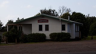
Kaniere School is a coeducational contributing primary (years 1–6) school with a roll of 92 students as of February 2024.[16][17]
Westland District is a territorial authority district on the West Coast of New Zealand's South Island. It is administered by the Westland District Council. The district's population is 8,940.
Hurunui District is a territorial local government district within the Canterbury Region on the east coast of New Zealand's South Island, north of Christchurch. It stretches from the east coast to the Main Divide. Its land area is 8,640.96 square kilometres (3,336.29 sq mi).
Wairakei is a small settlement, and geothermal area 8-kilometres north of Taupō, in the centre of the North Island of New Zealand, on the Waikato River. It is part of the Taupō Volcanic Zone and features several natural geysers, hot pools. boiling mud pools, and the Wairakei Power Station, a major geothermal electric power generating station.
Waddington is a small village located in the Selwyn District of the Canterbury region of New Zealand's South Island, near the Waimakariri Gorge.
Hawarden is a small town in the Canterbury region of New Zealand's South Island. It is located near Waikari, just off State Highway 7.
Pukawa or Pukawa Bay is a bay and a small township on the southern shores of Lake Taupō on New Zealand's North Island. It is off State Highway 41 between Turangi and Taumarunui, in the Taupō District and Waikato region.
Waipapa is a small town in the Bay of Islands, Northland, New Zealand. It is located on State Highway 10, approximately 10 minutes drive from Kerikeri, the nearest urban centre. Waipapa itself has no school with most pupils travelling to Kerikeri on a daily basis. It is governed by the Far North District council.
Spencerville is a semi-rural town on the east coast of Canterbury, New Zealand north of Christchurch. The town backs on to Bottle Lake Forest and includes a large park and 80 hectare camping ground. These amenities, as well as wetlands and an animal and bird park make the town a popular camping area for Christchurch residents.
Riversdale is a small town in the Southland region of New Zealand.
Ashburton District is a territorial authority district in the Canterbury Region of the South Island of New Zealand. It encompasses the town of Ashburton, a number of small towns and settlements and the surrounding rural area, roughly coterminous with Mid Canterbury. The district had a population of 36,800 as of June 2023.
Tai Tapu, previously known as Taitapu, is a small town adjacent to the Halswell River and nestled in the Port Hills, located 6 km east of the town of Lincoln and 18 km south west of Christchurch in the Canterbury region of New Zealand's South Island. State Highway 75 passes through the centre of the village, connecting Christchurch with Akaroa and the Banks Peninsula.
Waitematā and Gulf Ward is an Auckland Council ward which elects one councillor and covers the Great Barrier, Waiheke, and Waitematā Local Boards. The current councillor is Mike Lee.
Ngākuta Bay is a settlement and bay in the Marlborough Sounds, New Zealand. The bay is part of Grove Arm in Queen Charlotte Sound / Tōtaranui. Picton is about 11 km to the southeast via Queen Charlotte Drive. The bay was given its official name of Ngākuta Bay on 27 May 2021 and it has been known as Ngakuta Bay since at least 1865.
Woodbourne is a rural settlement in Marlborough, New Zealand. It is located on State Highway 6, 8 kilometres (5 mi) west of Blenheim, and 4 km (2 mi) east of Renwick. Woodbourne Airport is the major airport for Marlborough, and RNZAF Base Woodbourne shares the airport's runways.
Woodend Beach is a small rural community in the Waimakariri District, New Zealand.
Langs Beach is a locality on the shore of Bream Bay in the Whangarei District and Northland Region of New Zealand. It is about 5 km southeast of Waipu Cove and 10 km northwest of Mangawhai Heads.
Rainbows End is a rural settlement at the end of Green Road between the Oak River and Matakana River in Auckland Region. Matakana is 4.5 km (2.8 mi) to the north. Sandspit is across the Oak River directly south.
Glenbrook Beach is a rural community at the northern end of a peninsula formed between the Waiuku River and Taihiki River in Auckland, New Zealand. Waiuku is 14 km south by road.
Plummers Point is a rural settlement in the Western Bay of Plenty District and Bay of Plenty Region of New Zealand's North Island. It is on a headland on the southern side of Tauranga Harbour, opposite Motuhoa Island, and between Mangawhai Bay and Te Puna Estuary. The East Coast Main Trunk forms its southern boundary.
Te Puna West is a rural settlement in the Western Bay of Plenty District and Bay of Plenty Region of New Zealand's North Island. It is on a headland on the southern side of Tauranga Harbour, opposite Motuhoa Island, and on the eastern side of Te Puna Estuary, across from Plummers Point. The East Coast Main Trunk forms its southern boundary.
This page is based on this Wikipedia article Text is available under the CC BY-SA 4.0 license; additional terms may apply. Images, videos and audio are available under their respective licenses.