
The West Coast Gold Rush, on the West Coast of New Zealand's South Island, lasted from 1864 to 1867.
The West Coast Gold Rush, on the West Coast of New Zealand's South Island, lasted from 1864 to 1867.
The gold rush populated the area, which up until then had been visited by few Europeans. Gold was found near the Taramakau River in 1864 by two Māori, Ihaia Tainui and Haimona Taukau. In 1865–66 gold was discovered at Ōkārito, Bruce Bay (the scene of the Hunt's Duffer gold rush), around Charleston and along the Grey River.
Miners were attracted from the Otago Gold Rush, and from Victoria, Australia where the Victorian gold rush had nearly finished. By the end of 1864 there were an estimated 1800 prospectors on the West Coast, with many in the Hokitika area. Hokitika was in 1866 the most populous settlement in New Zealand with a population of more than 25,000, and boasted more than 100 pubs.
The Canterbury Provincial Council in Christchurch tasked their provincial engineer, Edward Dobson, to examine every possible pass to the West Coast from the watersheds of the Waimakariri, Taramakau and Hurunui Rivers. After finishing his examination, he declared that "Arthur's pass" was by far the most suitable to get to the gold fields; his son Arthur had discovered a pass in 1864. [1] The provincial government decided that a road was to be built between Christchurch and Hokitika over Arthur's Pass, a distance of 156 miles (251 km), and Edward Dobson was put in charge of the project. [1] The road was opened on 20 March 1866. [2]
In 1867 the rush began to decline, though gold mining continued on the Coast for some years. In the 1880s, quartz miners at Bullendale and Reefton were the first users of electricity in New Zealand. [3]
The main towns on the West Coast had been established, as well as many gold rush towns like Okarito (at one time the largest town on the Coast) and Charlestown (later renamed Charleston), which both almost vanished when the miners moved on. The Coast was the second-richest gold-bearing area of New Zealand after Otago.
Eleanor Catton's novel The Luminaries , which won the 2013 Man Booker Prize, is set in Hokitika during the West Coast Gold Rush. [4] This setting was partly inspired by Elsie Locke's classic New Zealand children's novel The Runaway Settlers, which also features the gold rush. [5] [6]
In Rose Tremains's 2003 novel The Colour a British couple emigrate to New Zealand and the husband gets swept up in the gold rush. The title refers to the gold prospectors' term for very fine particles of gold. [7]
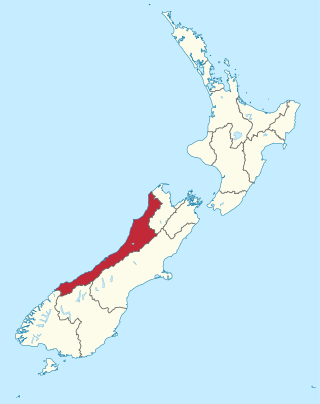
The West Coast is a region of New Zealand on the west coast of the South Island. It is administered by the West Coast Regional Council, and is known co-officially as Te Tai Poutini. It comprises the territorial authorities of Buller District, Grey District and Westland District. The principal towns are Westport, Greymouth and Hokitika. The region, one of the more remote areas of the country, is also the most sparsely populated. With a population of just 32,900 people, the West Coast is the least populous region in New Zealand. The population in the region grew by 0.4% over the year to July 2023.

Arthur's Pass is a mountain pass in the Southern Alps of the South Island of New Zealand. The pass sits 920 metres or 3,020 feet above sea level and marks part of the boundary between the West Coast and Canterbury regions. Located 140 km from Christchurch and 95 km from Greymouth, the pass comprises part of a saddle between the valleys of the Ōtira River and of the Bealey River. Arthur's Pass lies on the border of the Selwyn and Westland districts.

The Otago Gold Rush was a gold rush that occurred during the 1860s in Central Otago, New Zealand. This was the country's biggest gold strike, and led to a rapid influx of foreign miners to the area – many of them veterans of other hunts for the precious metal in California and Victoria, Australia. The number of miners reached its maximum of 18,000 in February 1864.

Westland District is a territorial authority district on the West Coast of New Zealand's South Island. It is administered by the Westland District Council. The district's population is 8,940.
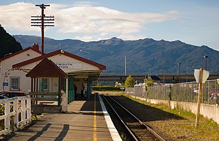
The Ross Branch, officially known as the Hokitika Line since 2011, and previously as the Hokitika Industrial Line, is a branch line railway that forms part of New Zealand's national rail network. It is located in the Westland District of the South Island's West Coast region and opened to Hokitika in 1893. A further extension to Ross operated from 1909 until 1980.
Philippe Joseph Viard was a French priest and the first Bishop of the Catholic diocese of Wellington, New Zealand.
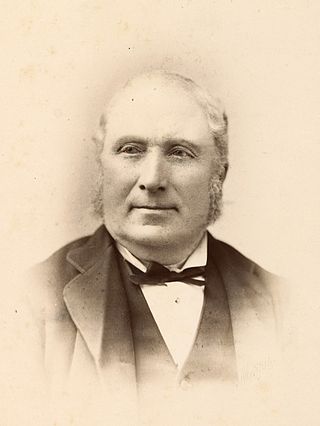
Edward Dobson was Provincial Engineer for Canterbury Province, New Zealand from 1854 to 1868.

Sir Arthur Dudley Dobson was a New Zealand surveyor, engineer and explorer. Born in London, he came to Lyttelton, New Zealand, in 1850 on one of the First Four Ships. He is best known for taking the first party of Europeans over Arthur's Pass.
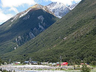
Arthur's Pass, previously called Camping Flat then Bealey Flats, and for some time officially Arthurs Pass, is a township in the Southern Alps of the South Island of New Zealand, located in the Selwyn district. It is a popular base for exploring Arthur's Pass National Park.

State Highway 73 is a major east-west South Island state highway in New Zealand connecting Christchurch on the east coast with Cass/Hokitika via the Southern Alps. It is mostly two lane, with some single-lane bridges north of Springfield but is mostly dual carriageway in Christchurch. The fourth and fifth-highest points of New Zealand's state highway network are on this road at Porters Pass and Arthur's Pass respectively.
Edwin Blake was a 19th-century Liberal Party Member of Parliament in Canterbury, New Zealand.

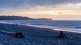
Bruce Bay is a bay and settlement in South Westland, New Zealand on the Tasman Sea. It is located on State Highway 6, 74 kilometres (46 mi) northeast of Haast and 45 kilometres (28 mi) southwest of Fox Glacier. The small settlement of Bruce Bay is located just south of the mouth of Mahitahi River. The bay is a nesting ground for the Fiordland crested penguin, and endemic Hector's dolphins and southern right whales can be observed from the shore on occasion. Some of the bush around the bay has been cleared for farming, and quartz stones can be found on the beach.

George Fairweather Moonlight was a New Zealand gold miner, farmer, storekeeper and hotel-keeper.
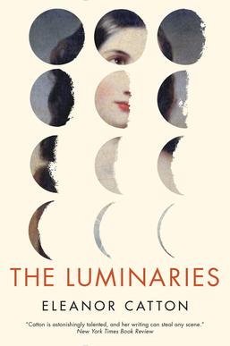
The Luminaries is a 2013 novel by Eleanor Catton. Set in New Zealand's South Island in 1866, the novel follows Walter Moody, a prospector who travels to the West Coast settlement of Hokitika to make his fortune on the goldfields. Instead, he stumbles into a tense meeting between twelve local men, and is drawn into a complex mystery involving a series of unsolved crimes. The novel's complex structure is based on the system of Western astrology, with each of the twelve local men representing one of the twelve signs of the zodiac, and with another set of characters representing planets in the solar system.

Westland County, also known as County of Westland, was a local government area on the West Coast of New Zealand's South Island. It existed from 1868 to 1873, and then from 1876 until 1989. In its first incarnation, it constituted the government for the area that was split from the Canterbury Province, with the West Coast Gold Rush having given the impetus for that split. It had the same administrative powers as a provincial council, but the legislative power rested with Parliament in Wellington. The first Westland County was the predecessor to Westland Province.

The West Coast Wilderness Trail has been funded as one of the projects of the New Zealand Cycle Trail. Once complete, the 139 kilometres (86 mi) track will connect Greymouth in the north with Ross in the south.
The Coromandel Gold Rushes on the Coromandel Peninsula and around the nearby towns of Thames and Waihi in New Zealand in the nineteenth century were moderately successful. Traces of gold were found about 1842. A small find was made near Coromandel in 1852; and a larger find in August 1867 when there was a modest rush. But Thames acquired a reputation for speculative holding of unworked ground despite regulations designed to check it, and some miners left for Queensland. Most of the gold was in quartz reefs rather than in more accessible alluvial deposits and had to be recovered from underground mines and extracted using stamping batteries.
Gillespies Beach is a black sand beach and settlement on the West Coast of New Zealand's South Island, 20 kilometres (12 mi) west of Fox Glacier township by road. It is bounded by Westland Tai Poutini National Park to the east, and the Tasman Sea to the west. The beach itself stretches about five kilometres (3.1 mi) from Gillespies Point / Kōhaihai in the north to Otorokua Point in the south.
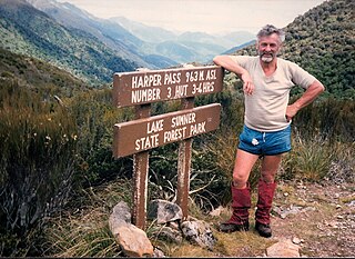
Harper Pass, previously known as Hurunui Pass or sometimes Taramakau Pass, is an alpine pass between Canterbury and the West Coast in New Zealand. It was the most important crossing for Māori to obtain pounamu. The first European crossed the pass in 1857 and the leader of the second party later that year, Leonard Harper, gave the pass its current name. It was of some interest to the settlers as the West Coast was part of Canterbury Province and it remained the only feasible route for some years. When the West Coast Gold Rush started in 1864, it became a heavily used crossing and remained so until October 1865, when a dray road over Arthur's Pass opened. The Arthur's Pass route was upgraded in March 1866 to coach traffic standard, and the much less direct route over Harper Pass fell out of use. It was restored in the 1930s as a tramping route and the Harper Pass Track, a four or five-day tramp, is today part of Te Araroa over its entire length.

George Dobson was a New Zealand surveyor and engineer who was murdered in the Brunner Gorge on the West Coast by the Burgess Gang after being mistaken for a local gold buyer.