Related Research Articles
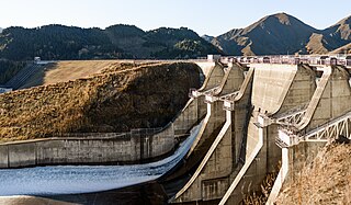
Benmore Dam is the largest dam within the Waitaki power scheme, located in the Canterbury Region of New Zealand's South Island. There are eight other power stations in the Waitaki Power Scheme.
Meridian Energy Limited is a New Zealand electricity generator and retailer. The company generates the largest proportion of New Zealand's electricity, generating 35 percent of the country's electricity in the year ending December 2014, and is the fourth largest retailer, with 14 percent of market share in terms of customers as of December 2015.

Manapōuri Power Station is an underground hydroelectric power station on the western arm of Lake Manapouri in Fiordland National Park, in the South Island of New Zealand. At 854 MW installed capacity, it is the largest hydroelectric power station in New Zealand, and the second largest power station in New Zealand. The station is noted for the controversy and environmental protests by the Save Manapouri Campaign against raising the level of Lake Manapouri to increase the station's hydraulic head, which galvanised New Zealanders and were one of the foundations of the New Zealand environmental movement.

Lake Mahinerangi is a lake formed when a dam was built on the Waipori River for hydroelectric generation. The lake is 35 kilometres (22 mi) to the west of Dunedin in New Zealand's South Island. Construction of the dam started in 1903 and since 1907, power has been produced.
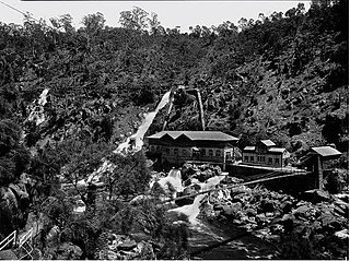
Duck Reach Power Station was the first publicly owned hydro-electric plant in the Southern Hemisphere, and provided the Tasmanian city of Launceston with hydro-electric power from its construction in 1895 to its closure in 1955.

Waddamana Hydro-Electric power station was the first hydro-electric power plant ever operated by the Tasmanian Hydro-Electric Department, opened in 1916.

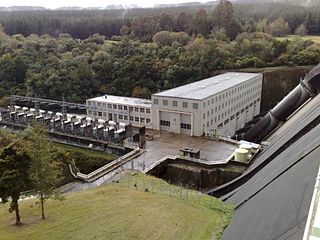
The Tungatinah Power Station is a conventional hydroelectric power station located in the Central Highlands region of Tasmania, Australia. The power station is situated on the Upper River Derwent catchment and is owned and operated by Hydro Tasmania.

The Aviemore Dam is a dam on the Waitaki River in New Zealand. The dam is a composite dam, with an embankment section, and a concrete section. Built in the 1960s it impounds Lake Aviemore.

The Monowai Power Station, fed by the Monowai River from Lake Monowai in Southland, New Zealand, was one of the earliest hydroelectric power stations in the country. Originally commissioned in 1925, it was refurbished between 2005 and 2007 and now contains modern turbines and plant, though the original buildings are still in use.

Hydroelectric power in New Zealand has been a part of the country's energy system for over 100 years and continues to provide more than half of the country's electricity needs. Hydroelectricity is the primary source of renewable energy in New Zealand. Power is generated the most in the South Island and is used most in the North Island.

Horahora Power Station was an early hydroelectric power station on the Waikato River in New Zealand. It was the country’s first large-scale power station, completed in 1913. Initially built to service a gold mine, the power station was expanded to supply a significant part of the North Island. The power station remained in use until was submerged by Lake Karapiro, which was formed to supply the larger Karapiro Power Station.

The Karapiro Power Station is a hydroelectric power station at Karapiro on the Waikato River, in the North Island of New Zealand. The power station lies on Lake Karapiro, a major rowing regatta venue. Karapiro is 30 kilometres (19 mi) south-east and upstream from the city of Hamilton and several kilometres from Cambridge. It is the last of the eight hydroelectric power stations on the Waikato River.

The Arnold Power Station is a hydroelectric facility fed from Lake Brunner on the Arnold River in West Coast, New Zealand, owned and operated by TrustPower. Commissioned in 1932, the plant is rated at 3 megawatts (4,000 hp) and has an average annual output of 25 gigawatt-hours (90 TJ).

The Cobb Power Station is a hydroelectric facility on the Cobb River, 112 kilometres (70 mi) northwest of Nelson, New Zealand. Since 2003, it has been owned and operated by Trustpower. Annual generation is approximately 190 gigawatt-hours (680 TJ).

Arapuni Power Station is a hydroelectric power station on the Waikato River, in the North Island of New Zealand. It is owned and operated by Mercury Energy, and is the seventh and penultimate hydroelectric power station on the Waikato River. It is also the oldest currently generating, the first government-built, and the largest capacity single hydroelectric power station on the Waikato River. The two power houses that make up the Maraetai Power Station have a larger combined capacity however.
Whakamaru Power Station is a hydroelectric power station on the Waikato River, in the North Island of New Zealand. It is the fourth hydroelectric power station on the Waikato River.
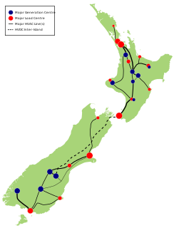
The National Grid is the nationwide system of electric power transmission in New Zealand. The grid is owned, operated and maintained by Transpower New Zealand, a state-owned enterprise, although some lines are owned by local distribution companies and leased to Transpower. In total, the national grid contains 11,803 kilometres (7,334 mi) of high-voltage lines and 178 substations.

Okere Falls Power Station is a hydroelectric power station that came into production in May 1901, bringing electricity to Rotorua. At the time, Rotorua was only the fourth town in New Zealand to have electricity. The power station was the first power station built by the New Zealand government, and it remained in operation until 1936.

Waipapa Power Station is a hydroelectric power station on the Waikato River, in the North Island of New Zealand. It is the sixth hydroelectric power station on the Waikato River. It is the smallest power station on the Waikato River.
The Piriaka power station is a hydroelectric power facility in Manawatū-Whanganui in New Zealand which draws water from behind a weir on the Whanganui River near Piriaka and diverts it through a canal and penstock to the Piriaka Power Station, which is located approximately 9 km southeast of the town of Taumarunui, via SH4. The power station discharges back into the Whanganui River.
References
- ↑ "Phoenix Mine Hydro Electric Plant Site". Heritage New Zealand . Retrieved 9 October 2011.
- 1 2 P.G. Petchey (2006). "Gold and electricity - Archaeological survey of Bullendale, Otago" (PDF). Department of Conservation. Retrieved 6 April 2012.
- 1 2 Martin, p. 19-21
- ↑ Reilly, H p. 17-18
- ↑ "Historic Bullendale Hydro Heritage". Department of Conservation . Retrieved 10 October 2011.