Frankton, Otago

Last updated

Frankton
Queenstown Airport view from Deer Park.jpg
The view from Peninsula Hill
Frankton, Otago
Coordinates: 45°1′S168°44′E / 45.017°S 168.733°E / -45.017; 168.733
CountryNew Zealand
City Queenstown
Local authority Queenstown-Lakes District Council
Electoral wardQueenstown-Wakatipu Ward
Area
[1]
  Land762 ha (1,883 acres)
Population
 (June 2022) [2]
  Total3,780
Airport(s) Queenstown Airport
Queenstown Hill Quail Rise Shotover Country
Queenstown East
Pfeil oben.svg
Pfeil links.svgFranktonPfeil rechts.svg
Pfeil unten.svg
Gibbston
(Frankton Arm) Kelvin Peninsula (The Remarkables)
The view across Kawarau River. FranktonNZ.jpg
The view across Kawarau River.

Frankton is a suburb of the town of Queenstown in the South Island of New Zealand, it was formerly a separate settlement.

Contents

History

Frankton was named after Frances—the wife of the area's first European settler William Gilbert Rees. [3] He started farming at Queenstown in 1860, and Frankton was established in 1863.

The Otago Witness of 14 February 1863 remarked that 'with all its natural advantages nothing can prevent Frankton being the chief township of the district'. [4] The government moved all its buildings including the warden's Court and the gold receiver to Frankton. With no road between Queenstown and Frankton this created all sorts of inconveniences. The police at Queenstown Police Station travelled daily to the Court at Frankton. After a banquet in June 1863, hosting the secretary of the goldfields, and the police commissioner St. John Branigan, the decision was reversed.

This historic Kawerau Falls Bridge was built between 22 December 1924 and August 1926. It was constructed as a dam to lower the water level in the Kawarau River to enable the river bed to be mined. This idea may have been first suggested by Julius Vogel eighth Premier of New Zealand and Otago goldfields journalist in his 1889 book Anno Domini 2000 – A Woman's Destiny. The dam gates were shut from 15 June to 15 August. This caused the water to back up from behind the bridge to the Shotover River confluence. Less gold was found than expected and the project was largely unsuccessful. In May 1932, during the Depression, the gates were shut again for six weeks for unemployed men to fossick for gold. [5]

Location

Frankton is located at the end of a large inlet in the northeastern shore of Lake Wakatipu known as the Frankton Arm, on State Highway 6. It is one terminus of the short State Highway 6A, which runs seven kilometres west from there to Queenstown. [6]

Frankton is located on the edge of a larger area referred to as the Frankton Flats, which is the area of land approximately bounded by Lake Wakatipu, the Kawarau and Shotover Rivers, and State Highway 6 to towards Cromwell. The Frankton Flats is located in the Wakatipu Basin and enjoys longer sunshine hours, particularly in winter, than the majority of land in central Queenstown, which is predominantly south facing.

Demographics

Frankton covers 7.62 km2 (2.94 sq mi) [1] and had an estimated population of 3,780 as of June 2022, [2] with a population density of 496 people per km2.

Historical population
YearPop.±% p.a.
20062,154    
20132,307+0.99%
20182,895+4.65%
Source: [7]

Frankton had a population of 2,895 at the 2018 New Zealand census, an increase of 588 people (25.5%) since the 2013 census, and an increase of 741 people (34.4%) since the 2006 census. There were 1,017 households. There were 1,521 males and 1,377 females, giving a sex ratio of 1.1 males per female. The median age was 32.8 years (compared with 37.4 years nationally), with 339 people (11.7%) aged under 15 years, 861 (29.7%) aged 15 to 29, 1,398 (48.3%) aged 30 to 64, and 297 (10.3%) aged 65 or older.

Ethnicities were 67.5% European/Pākehā, 4.7% Māori, 2.1% Pacific peoples, 20.1% Asian, and 11.2% other ethnicities (totals add to more than 100% since people could identify with multiple ethnicities).

The proportion of people born overseas was 49.7%, compared with 27.1% nationally.

Although some people objected to giving their religion, 52.1% had no religion, 32.8% were Christian, 4.6% were Hindu, 1.1% were Muslim, 1.5% were Buddhist and 3.2% had other religions.

Of those at least 15 years old, 669 (26.2%) people had a bachelor or higher degree, and 219 (8.6%) people had no formal qualifications. The median income was $39,300, compared with $31,800 nationally. 390 people (15.3%) earned over $70,000 compared to 17.2% nationally. The employment status of those at least 15 was that 1,788 (70.0%) people were employed full-time, 321 (12.6%) were part-time, and 24 (0.9%) were unemployed. [7]

Economy

Remarkables Park Town Centre, Frankton Remarkables Park Frankton lower facade.JPG
Remarkables Park Town Centre, Frankton

Queenstown Airport

Queenstown Airport is located at Frankton. The airport provides direct international flights to Australia, and domestic flights around New Zealand.

Remarkables Town Centre

Remarkables Park Town Centre has 600 carparks and 60 retailers, H & J Smith, Harvey Norman and New World. [8]

Queenstown Central Shopping Centre

Queenstown Central Shopping Centre opened in 2016, and covers an area of more than 4,000 m². [9] It features 250 carparks and 45 shops, [10] including Kmart. [11]

Queenstown Events Centre

The Queenstown Events Centre is also located in Frankton and contains the main recreational and sporting facilities for Queenstown residents. Facilities at the Queenstown Events Centre include Alpine Aqualand (swimming pools and hydro slide), sports fields for football and cricket, cricket nets, indoor courts and events facilities. [12]

Education

Remarkables Primary School is a co-educational state primary school for Year 1 to 8 students, [13] [14] with a roll of 445 as of April 2023. [15]

KingsView School is a co-educational state-integrated Catholic primary school for Year 1 to 8 students, [16] [17] with a roll of 66. [18]

Wakatipu High School is a co-educational state secondary school for Year 9 to 13 students, [19] [20] with a roll of 1339. [21]

Related Research Articles

<span class="mw-page-title-main">Queenstown, New Zealand</span> Resort town in Otago, New Zealand

Queenstown is a resort town in Otago in the south-west of New Zealand's South Island. It has an urban population of 15,800.

<span class="mw-page-title-main">Balclutha, New Zealand</span> Town in Otago, New Zealand

Balclutha is a town in South Otago, lying towards the end of the Clutha River, on the east coast of the South Island of New Zealand. It is about halfway between Dunedin and Gore on the Main South Line railway, State Highway 1 and the Southern Scenic Route. Balclutha has a population of 4,300, and is the largest town in South Otago.

<span class="mw-page-title-main">Cromwell, New Zealand</span> Town in Otago, New Zealand

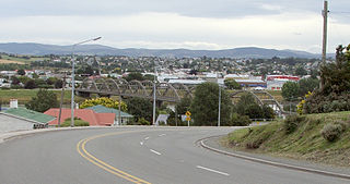
Cromwell is a town in Central Otago region of the South Island of New Zealand. Cromwell is located on the shores of Lake Dunstan where the Kawarau river joins Lake Dunstan. Cromwell was established during the Otago gold rush and is now more known as one of the sub regions of the Central Otago wine region. In 2018, the town of Cromwell was home to a population of 5610 people.

Makarora is a small community within the Queenstown-Lakes District of the Otago region of the South Island of New Zealand.

<span class="mw-page-title-main">Kawarau River</span> River in the South Island of New Zealand

The Kawarau River is a river in the South Island of New Zealand. It drains Lake Wakatipu in northwestern Otago via the lake's Frankton Arm. The river flows generally eastwards for about 60 kilometres (37 mi) and passes through the steep Kawarau Gorge until it joins Lake Dunstan near Cromwell. Before the construction of the Clyde High Dam, the Kawarau joined the Clutha River / Mata-Au in a spectacular confluence at Cromwell. The Shotover River enters the Kawarau from the north; the Nevis River enters it from the south. With many rapids and strong currents, the river can be dangerous and has claimed many lives. It is popular for bungy jumping and kayaking.

Tokoroa is the fifth-largest town in the Waikato region of the North Island of New Zealand and largest settlement in the South Waikato District. Located 30 km southwest of Rotorua, close to the foot of the Mamaku Ranges, it is midway between Taupo and Hamilton on State Highway 1.

<span class="mw-page-title-main">Lake Wakatipu</span> Lake in the South Island of New Zealand

Lake Wakatipu is an inland lake in the South Island of New Zealand. It is in the southwest corner of the Otago region, near its boundary with Southland. Lake Wakatipu comes from the original Māori name Whakatipu wai-māori.

<span class="mw-page-title-main">Glenorchy, New Zealand</span> Town in Otago, New Zealand

Glenorchy is a small settlement at the northern end of Lake Wakatipu in the South Island region of Otago, New Zealand. It is approximately 45 km (28 mi) by road or boat from Queenstown, the nearest large town. There are two pubs, a café and a range of small shops in the town catering mainly to tourists but also to the small resident population. There is also a small airstrip which caters to small planes.

<span class="mw-page-title-main">Taieri Mouth</span> Rural settlement in Otago, New Zealand

Taieri Mouth is a small fishing village at the mouth of the Taieri River, New Zealand. Taieri Island (Moturata) lies in the ocean several hundred metres off the river's mouth.

<span class="mw-page-title-main">Palmerston North Central</span> Central business district of Palmerston North

Palmerston North Central is the central suburb and central business district of Palmerston North, on New Zealand's North Island.

Tauhara is a suburb and geothermal area of Taupō in the Waikato region of New Zealand's North Island.

<span class="mw-page-title-main">Wakatipu Basin</span>

The Whakatipu Basin is a plain surrounded by mountains in Queenstown Lakes District, in the southern South Island of New Zealand.

Queenstown Police Station is the largest police station in the Otago Lakes Central Area which is one of three policing areas in the Southern District of the New Zealand Police. The Otago Lakes Central Area headquarters has returned to Queenstown Police Station after a period at Alexandra Police Station. The area of responsibility covered by the Queenstown Police extends from Kingston in the south, to the Crown Range summit in the north, and from Glenorchy and its environs in the west, to the Roaring Meg power station in the Kawarau Gorge in the east.

<span class="mw-page-title-main">Queenstown Trail</span>

The Queenstown Trail is a cycle and walking trail funded as one of the projects of the New Zealand Cycle Trail (NZCT) system in Otago, New Zealand. It links the towns of Queenstown, Arrowtown, the suburb of Jack's Point and the area of Gibbston. It is at least 110 km in length but is not linear and instead follows the terrain often near rivers and lakes to link key places in a series of tracks that also access public land. In some places it also passes through private land such as working farms and users are encouraged to stay on the trail. The trail is a joint venture between the Government, Queenstown Lakes District Council and the Queenstown Trails Trust.

Nelson South is an inner suburb of Nelson, New Zealand. It lies to the southwest of Nelson city centre, between it and Bishopdale, close to the foot of The Grampians. The main inland route to Stoke, New Zealand, Waimea Road, is Nelson South's main road.

<span class="mw-page-title-main">Shotover Country</span> Suburb in Queenstown, New Zealand

Shotover Country is a suburb of Queenstown in the South Island of New Zealand. It has around 810 sections and was originally 202 hectares when first rezoned from rural to residential. The suburb began in 2012 when sections first came up for sale.

<span class="mw-page-title-main">Kelvin Peninsula</span> Suburb of the town of Queenstown in the South Island of New Zealand

Kelvin Peninsula is a peninsula on the shore of Lake Wakatipu in New Zealand's Otago Region. The peninsula lies between the main body of Lake Wakatipu and the lake's Frankton Arm and its outlet, the Kawarau River. The centre of Queenstown lies on the opposite shore of the Frankton Arm. The peninsula was formerly called Kelvin Heights Peninsula. The name Kelvin Heights is still used for the Queenstown suburb which sits on the peninsula.

Riverdale is a suburb of Gisborne, in the Gisborne District of New Zealand's North Island.

<span class="mw-page-title-main">Hastings Central</span> Central Business District of Hastings, New Zealand

Hastings Central is the central suburb and business district of Hastings City, in the Hawke's Bay Region of New Zealand's North Island.

<span class="mw-page-title-main">Castlecliff</span> Suburb of Whanganui

Castlecliff is a suburb of Whanganui, in the Whanganui District and Manawatū-Whanganui region of New Zealand's North Island.

References

  1. 1 2 "ArcGIS Web Application". statsnz.maps.arcgis.com. Retrieved 23 December 2021.
  2. 1 2 "Population estimate tables - NZ.Stat". Statistics New Zealand . Retrieved 25 October 2022.
  3. William Gilbert Rees information
  4. Miller, F.W.G., (1949) Golden Days of Lake County. Whitcombe and Tombs. pg68.
  5. Miller. F.W.G. (1949) Golden Days of Lake County. Whitcomb and Toombs. p328-334.
  6. Harriss, Gavin (July 2021). Frankton, Otago (Map). NZ Topo Map.
  7. 1 2 "Statistical area 1 dataset for 2018 Census". Statistics New Zealand. March 2020. Frankton (348400). 2018 Census place summary: Frankton
  8. "Remarkable Pak Town Centre - Stores". remarkablesparktowncentre.co.nz. Stride Property.
  9. Williams, Guy (30 May 2020). "Ex worker facing $38k fine over Kmart build breach". Otago Daily Times.
  10. "Queenstown Central Shopping Centre". queenstowncentral.co.nz. Destination Queenstown.
  11. "Queenstown Central - Centre Map". queenstowncentral.co.nz. Colliers International.
  12. Lakes Leisure
  13. "Remarkables Primary School Official School Website". remarkablesprimary.school.nz.
  14. "Remarkables Primary School Ministry of Education School Profile". educationcounts.govt.nz. Ministry of Education.
  15. "Remarkables Primary School Education Review Office Report". ero.govt.nz. Education Review Office.
  16. "KingsView School Official School Website". kingsview.school.nz.
  17. "KingsView School Ministry of Education School Profile". educationcounts.govt.nz. Ministry of Education.
  18. "KingsView School Education Review Office Report". ero.govt.nz. Education Review Office.
  19. "Official School Website". wakatipu.school.nz.
  20. "Ministry of Education School Profile". educationcounts.govt.nz. Ministry of Education.
  21. "Education Review Office Report". ero.govt.nz. Education Review Office.