Arthurs Point

Last updated

Arthurs Point
Arthurs Point.jpg
The suburb of Arthurs Point as viewed from the Moonlight Track.
Arthurs Point
Coordinates: 44°59′19″S168°40′18″E / 44.988670°S 168.671553°E / -44.988670; 168.671553
CountryNew Zealand
City Queenstown
Local authority Queenstown-Lakes District Council
Electoral wardQueenstown-Wakatipu Ward
Area
[1]
  Land552 ha (1,364 acres)
Population
 (June 2022) [2]
  Total1,360
(Mount Dewar)
(Ben Lomond)
Pfeil oben.svg
Pfeil links.svgArthurs PointPfeil rechts.svg
Pfeil unten.svg
Dalefield
Queenstown (Queenstown Hill)
Shotover River and Edith Cavell Bridge at Arthurs Point Shotover River at Edith Cavell Bridge at Arthur's Point 2.jpg
Shotover River and Edith Cavell Bridge at Arthurs Point

Arthurs Point is a suburb of Queenstown in the South Island of New Zealand. It is situated near Queenstown Hill and Bowen Peak and is not far from central Queenstown. Another distinctive aspect for the area is that the Shotover Jet company operates jetboats on the Shotover River which passes under the Edith Cavell Bridge.

Contents

History

Arthurs Point was named after Thomas Arthur who, in November 1862, discovered gold in the banks of the nearby Shotover River. [3]

Demographics

Arthurs Point covers 5.52 km2 (2.13 sq mi) [1] and had an estimated population of 1,360 as of June 2022, [2] with a population density of 246 people per km2.

Historical population
YearPop.±% p.a.
2006411    
2013807+10.12%
20181,128+6.93%
Source: [4]

Arthurs Point had a population of 1,128 at the 2018 New Zealand census, an increase of 321 people (39.8%) since the 2013 census, and an increase of 717 people (174.5%) since the 2006 census. There were 354 households. There were 546 males and 585 females, giving a sex ratio of 0.93 males per female. The median age was 34.9 years (compared with 37.4 years nationally), with 234 people (20.7%) aged under 15 years, 219 (19.4%) aged 15 to 29, 636 (56.4%) aged 30 to 64, and 39 (3.5%) aged 65 or older.

Ethnicities were 91.0% European/Pākehā, 6.4% Māori, 1.3% Pacific peoples, 5.9% Asian, and 3.2% other ethnicities (totals add to more than 100% since people could identify with multiple ethnicities).

The proportion of people born overseas was 37.5%, compared with 27.1% nationally.

Although some people objected to giving their religion, 69.9% had no religion, 21.0% were Christian, 1.6% were Hindu, 1.6% were Buddhist and 1.6% had other religions.

Of those at least 15 years old, 312 (34.9%) people had a bachelor or higher degree, and 39 (4.4%) people had no formal qualifications. The median income was $47,900, compared with $31,800 nationally. 264 people (29.5%) earned over $70,000 compared to 17.2% nationally. The employment status of those at least 15 was that 654 (73.2%) people were employed full-time, 138 (15.4%) were part-time, and 9 (1.0%) were unemployed. [4]

Tracks

Arthurs Point has access to the moonlight track, a long walking/running track which gives access to Ben Lomond and Moke Lake. The short Oxenbridge Tunnel Track can also be accessed from near the Edith Cavell bridge and displays some of the mining history of the area.

Related Research Articles

<span class="mw-page-title-main">Shotover River</span> River in New Zealand

The Shotover River is located in the Otago region of the South Island of New Zealand. The name correctly suggests that this 75-kilometre (47 mi) long river is fast flowing, with numerous rapids. The river flows generally south from the Southern Alps on its journey running through the Skippers Canyon, draining the area between the Richardson Mountains and the Harris Mountains, before flowing into the Kawarau River east of Queenstown.

<span class="mw-page-title-main">Glenorchy, New Zealand</span> Town in Otago, New Zealand

Glenorchy is a small settlement at the northern end of Lake Wakatipu in the South Island region of Otago, New Zealand. It is approximately 45 km (28 mi) by road or boat from Queenstown, the nearest large town. There are two pubs, a café and a range of small shops in the town catering mainly to tourists but also to the small resident population. There is also a small airstrip which caters to small planes.

<span class="mw-page-title-main">Lumsden, New Zealand</span> Town in the South Island of New Zealand

Lumsden is a town in Southland, New Zealand. Lying in a gap in the surrounding hills, Lumsden is the location of a major junction on state highway six. Lumsden is 81 kilometres north of Invercargill, 106 kilometres south of Queenstown, 59 kilometres west of Gore and 77 kilometres east of Te Anau.

<span class="mw-page-title-main">Kingston, New Zealand</span> Rural settlement in Otago, New Zealand

Kingston is a small town at the southernmost end of Lake Wakatipu, just north of the border of Otago and Southland, in New Zealand's South Island. It is 47 kilometres south of Queenstown by a road, "The Devil's Staircase", which winds between the lake to the west and The Remarkables mountains to the east. It is 70 kilometres north of Lumsden, and close to the headwaters of the Mataura River.

Craigieburn is the name of a settlement and several geographic features in northwest Canterbury, in New Zealand's South Island.

<span class="mw-page-title-main">Queenstown-Lakes District</span> Territorial authority district in Otago, New Zealand

Queenstown-Lakes District, a local government district, is in the Otago Region of New Zealand that was formed in 1986. It is surrounded by the districts of Central Otago, Southland, Westland and Waitaki.

<span class="mw-page-title-main">Frankton, Otago</span> Suburb in Queenstown, New Zealand

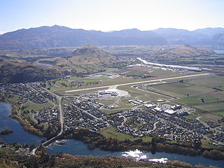
Frankton is a suburb of the town of Queenstown in the South Island of New Zealand, it was formerly a separate settlement.

<span class="mw-page-title-main">Wairau Valley</span> Place in Marlborough, New Zealand

Wairau Valley is the valley of the Wairau River in Marlborough, New Zealand and also the name of the main settlement in the upper valley. State Highway 63 runs through the valley. The valley opens onto the Wairau Plain, where Renwick and Blenheim are sited. The Alpine–Wairau Fault runs along the length of the valley.

<span class="mw-page-title-main">Wakatipu Basin</span>

The Whakatipu Basin is a plain surrounded by mountains in Queenstown Lakes District, in the southern South Island of New Zealand.

<span class="mw-page-title-main">Edith Cavell Bridge</span> Bridge in near Queenstown, New Zealand

Edith Cavell Bridge is a bridge over the Shotover River in the Otago region in the South Island of New Zealand that stands at 47.8 metres (157 ft) tall. It is registered by Heritage New Zealand as a Category I heritage structure.

<span class="mw-page-title-main">Gibbston</span> Community in Otago, New Zealand

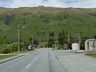
Gibbston is a community in the Wakatipu Basin in the Otago region of the South Island, New Zealand. Through the valley runs the Kawarau River which forms the Kawarau Gorge.

<span class="mw-page-title-main">Closeburn, New Zealand</span> Locality in Queenstown Lakes District, Otago, New Zealand

Closeburn is a locality in Queenstown-Lakes District in the South Island of New Zealand. It is located a 10-minute drive from Queenstown on the Glenorchy–Queenstown Road.

<span class="mw-page-title-main">Lake Hayes Estate</span> Town in Otago, New Zealand

Lake Hayes Estate is a town nearby to Queenstown in the South Island of New Zealand. It is named after and situated near Lake Hayes; however, the lake is not visible from most parts of the estate. The population of the town at the 2018 census was 2,470. The main access to Lake Hayes Estate is off State Highway 6. To the west is the newer sub division of Shotover Country which can be accessed via Jones Road.

<span class="mw-page-title-main">Jack's Point</span> Residential subdivision in Central Otago, New Zealand

Jack's Point is a luxury estate in Central Otago, New Zealand, covering 1,200 hectares of land. It is located 6 km south of Queenstown, at the foot of The Remarkables and close to the edge of Lake Wakatipu. It is known for its golf course. It is rated among the top 10 lifestyle estates in the world.

Quail Rise is a residential suburb of Queenstown in the South Island of New Zealand.

<span class="mw-page-title-main">Shotover Country</span> Suburb in Queenstown, New Zealand

Shotover Country is a suburb of Queenstown in the South Island of New Zealand. It has around 810 sections and was originally 202 hectares when first rezoned from rural to residential. The suburb began in 2012 when sections first came up for sale.

<span class="mw-page-title-main">Takapu Valley</span> Suburb of Wellington City, New Zealand

Takapu Valley, one of the northern suburbs of Wellington, New Zealand, is a rural area. The only road, Takapu Road, which runs by the Takapu Stream, goes down past Grenada North to the intersection with the Johnsonville-Porirua Motorway, and to Tawa where most facilities are. There is a supermarket and the Takapu Road Railway Station near the motorway intersection, but neither are in the valley itself.

<span class="mw-page-title-main">Kelvin Peninsula</span> Suburb of the town of Queenstown in the South Island of New Zealand

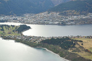
Kelvin Peninsula is a peninsula on the shore of Lake Wakatipu in New Zealand's Otago Region. The peninsula lies between the main body of Lake Wakatipu and the lake's Frankton Arm and its outlet, the Kawarau River. The centre of Queenstown lies on the opposite shore of the Frankton Arm. The peninsula was formerly called Kelvin Heights Peninsula. The name Kelvin Heights is still used for the Queenstown suburb which sits on the peninsula.

<span class="mw-page-title-main">Queenstown East</span> Suburb in Queenstown, New Zealand

Queenstown East is a residential suburb of Queenstown in the South Island of New Zealand. State Highway 6A runs through it.

Sunshine Bay is an inlet of Lake Wakatipu and suburb of Queenstown in the South Island of New Zealand. It is located on the lower slopes of the Ben Lomond mountain, west of Fernhill, on the northern side of the lake.

References

  1. 1 2 "ArcGIS Web Application". statsnz.maps.arcgis.com. Retrieved 16 December 2021.
  2. 1 2 "Population estimate tables - NZ.Stat". Statistics New Zealand . Retrieved 25 October 2022.
  3. Tyerman, Justine (30 November 2013). "Arthurs Point: Soakers and swingers". The New Zealand Herald. Retrieved 8 December 2013.
  4. 1 2 "Statistical area 1 dataset for 2018 Census". Statistics New Zealand. March 2020. Arthurs Point (347400). 2018 Census place summary: Arthurs Point