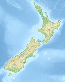
Aoraki / Mount Cook is the highest mountain in New Zealand. Its height since 2014 is listed as 3,724 metres, down from 3,764 m (12,349 ft) before December 1991, due to a rockslide and subsequent erosion. It lies in the Southern Alps, the mountain range which runs the length of the South Island. A popular tourist destination, it is also a favourite challenge for mountain climbers. Aoraki / Mount Cook consists of three summits, from South to North the Low Peak, Middle Peak and High Peak. The summits lie slightly south and east of the main divide of the Southern Alps, with the Tasman Glacier to the east and the Hooker Glacier to the southwest.

Fiordland is a geographic region of New Zealand in the south-western corner of the South Island, comprising the western-most third of Southland. Most of Fiordland is dominated by the steep sides of the snow-capped Southern Alps, deep lakes, and its steep, glacier-carved and now ocean-flooded western valleys. The name "Fiordland" comes from a variant spelling of the Scandinavian word for this type of steep valley, "fjord". The area of Fiordland is dominated by, and very roughly coterminous with, Fiordland National Park, New Zealand's largest National Park.

Mount Taranaki, or Mount Egmont, is an active but quiescent stratovolcano in the Taranaki region on the west coast of New Zealand's North Island. Although the mountain is more commonly referred to as Taranaki, it has two official names under the alternative names policy of the New Zealand Geographic Board. The 2,518 metres (8,261 ft) mountain is one of the most symmetrical volcanic cones in the world. There is a secondary cone, Fanthams Peak, 1,966 metres (6,450 ft), on the south side. Because of its resemblance to Mount Fuji, Taranaki provided the backdrop for the movie The Last Samurai.

Mount Aspiring / Tititea is New Zealand's 23rd-highest mountain. It is the country's highest outside the Aoraki / Mount Cook region.
In topography, prominence measures the height of a mountain or hill's summit relative to the lowest contour line encircling it but containing no higher summit within it. It is a measure of the independence of a summit. A peak's key col is a unique point on this contour line and the parent peak is some higher mountain, selected according to various objective criteria.

These are lists of mountains and mountain ranges in Ireland. Those within Northern Ireland, or on the border, are marked with an asterisk, while the rest are within the Republic of Ireland. Where mountains are ranked by height, the definition of the "topographical prominence", used to classify the mountain, is noted. In British definitions, a height of 600 metres (1,969 ft) is required for a "mountain", whereas in Ireland, a lower threshold of 500 metres (1,640 ft) is sometimes advocated.
The Paparoa Range is a mountain range in the West Coast region of New Zealand's South Island. It is located along the coast between the Buller and Grey Rivers, with the Inangahua River to the east. Some of the range is protected as the Paparoa National Park. Within this park, the 1995 Cave Creek disaster occurred.

Ben Lomond is a mountain located close to Queenstown, New Zealand. It was named after Ben Lomond in Scotland by the early shepherd Duncan McAusland. The summit lies approximately 4 km northwest of the town centre, and reaches a height of 1,748 metres (5,735 ft). Connected to Ben Lomond is the large but slightly shorter Bowen Peak and Bob's Peaks while nearby is the dominant feature of Queenstown Hill. There are scenic views available from a range of places on the mountain with the very top giving a 360-degree panorama of much of the Wakatipu Basin including Lake Wakatipu, The Remarkables Mountains, Cecil Peak and Walter Peak.

An ultra-prominent peak, or Ultra for short, is a mountain summit with a topographic prominence of 1,500 metres (4,900 ft) or more; it is also called a P1500. There are approximately 1,524 such peaks on Earth. Some peaks, such as the Matterhorn and Eiger, are not Ultras because they are connected to higher mountains by high cols and therefore do not achieve enough topographic prominence.

The topographic isolation of a summit is the minimum great-circle distance to a point of equal elevation, representing a radius of dominance in which the peak is the highest point. It can be calculated for small hills and islands as well as for major mountain peaks, and can even be calculated for submarine summits.

Mount Tutoko is the highest peak in Fiordland National Park, in southwest New Zealand. It lies between the Hollyford Valley and Milford Sound, 15 kilometres due north of the Homer Tunnel at the northern end of the Darren Mountains. The glacier-covered mountain rises to a height of 2,723 metres (8,934 ft) and is visible from the Hollyford Track. Two slightly lower summits lie just to the south of the main peak.
Roys Peak is a mountain in New Zealand, standing between Wanaka and Glendhu Bay. It offers a full-day walk, with views across Lake Wanaka and up to the peak of Mount Aspiring/Tititea. The track zigzags steeply up the side of Mount Roy, through thick grass until the ridge to the summit.
Mount Bowen is a peak in the Prince Albert Mountains, Victoria Land, Antarctica. It is 1,875 metres (6,152 ft) high, standing north of the Davis Glacier and 6 nautical miles (11 km) south-southwest of Mount Howard. The mountain is primarily composed of layers of sandstone, and the peak is quite black. It was discovered by the British National Antarctic Expedition of 1901–1904, which named it for Charles C. Bowen, one of the men who gave the expedition much assistance in New Zealand.
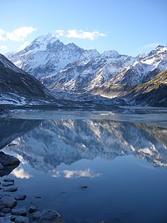
Walter Peak is a mountain located near Queenstown, New Zealand. It has a height of 1,800 metres (5,906 ft).
Cecil Peak is a mountain in the Wakatipu Basin, New Zealand and reaches a height of 1,978 metres. It is on the south side of Lake Wakatipu, south south-west of Queenstown and is highly prominent from around this area.

Mount Sefton is a mountain in the Aroarokaehe Range of the Southern Alps of New Zealand, just 12 kilometres (7.5 mi) south of Aoraki / Mount Cook. To the south lies Mount Brunner, and to the north The Footstool, both more than 400 metres (1,300 ft) shorter.

The Hillary Montes are mountains that reach 3.5 km above the surface of the dwarf planet Pluto. They are located northwest of Norgay Montes in the southwest border area of Sputnik Planitia in the south of Tombaugh Regio. The Hillary Montes were first viewed by the New Horizons spacecraft on 14 July 2015, and announced by NASA on 24 July 2015.