Luggate

Last updated • 3 min readFrom Wikipedia, The Free Encyclopedia

Luggate
Rural settlement
Red Bridge across the Clutha River at Luggate.jpg
The Red Bridge across the Clutha River at Luggate
Luggate
Coordinates: 44°44′56″S169°16′11″E / 44.7488°S 169.2696°E / -44.7488; 169.2696
CountryNew Zealand
Region Otago
Territorial authority Queenstown Lakes District
WardWānaka-Upper Clutha Ward
CommunityWānaka-Upper Clutha Community
Electorates
Government
  Territorial authority Queenstown-Lakes District Council
  Regional council Otago Regional Council
   Mayor of Queenstown-Lakes Glyn Lewers
   Waitaki MP Miles Anderson
   Te Tai Tonga MP Tākuta Ferris
Area
[1]
  Total
1.19 km2 (0.46 sq mi)
Population
 (June 2024) [2]
  Total
650
  Density550/km2 (1,400/sq mi)
Time zone UTC+12 (NZST)
  Summer (DST) UTC+13 (NZDT)
Postcode
9383
Area code03
Local iwi Ngāi Tahu

Luggate is a small town in the South Island of New Zealand. [3] It is located on State Highway 6 between Wānaka and Cromwell, near the junction with State Highway 8A, approximately 15 km from the Wānaka township, just past Wānaka Airport. The town is nestled below the northern end of the Criffel Range of mountains.

Contents

The Luggate 'Grandview Bridge' is a local icon listed highly in the Queenstown Lakes District Council's Historic Register. It was opened on October 28, 1915, and has been described as "one of the most attractively proportioned steel truss road bridges in the country." [4] It is 103.7 metres long, and features a 61-metre Baltimore through truss, another 30.5m truss and a 12.2m rolled steel joist end span.

Demographics

Luggate is described by Statistics New Zealand as a rural settlement. It covers 1.19 km2 (0.46 sq mi) [1] and had an estimated population of 650 as of June 2024, [2] with a population density of 546 people per km2. It is part of the Upper Clutha Valley statistical area.

Historical population of Luggate
YearPop.±% p.a.
2006189    
2013279+5.72%
2018474+11.18%
Source: [5]

Luggate had a population of 474 at the 2018 New Zealand census, an increase of 195 people (69.9%) since the 2013 census, and an increase of 285 people (150.8%) since the 2006 census. There were 162 households, comprising 243 males and 231 females, giving a sex ratio of 1.05 males per female, with 114 people (24.1%) aged under 15 years, 60 (12.7%) aged 15 to 29, 243 (51.3%) aged 30 to 64, and 51 (10.8%) aged 65 or older.

Ethnicities were 91.8% European/Pākehā, 10.1% Māori, 0.6% Pasifika, 3.8% Asian, and 1.3% other ethnicities. People may identify with more than one ethnicity.

Although some people chose not to answer the census's question about religious affiliation, 69.0% had no religion, 20.9% were Christian, 0.6% had Māori religious beliefs, 0.6% were Hindu, 0.6% were Buddhist and 0.6% had other religions.

Of those at least 15 years old, 66 (18.3%) people had a bachelor's or higher degree, and 51 (14.2%) people had no formal qualifications. 51 people (14.2%) earned over $70,000 compared to 17.2% nationally. The employment status of those at least 15 was that 219 (60.8%) people were employed full-time, 63 (17.5%) were part-time, and 3 (0.8%) were unemployed. [5]

Upper Clutha Valley

The Upper Clutha Valley statistical area also includes Hāwea Flat and covers 159.80 km2 (61.70 sq mi). [1] It had an estimated population of 1,570 as of June 2024, [6] with a population density of 9.8 people per km2.

Historical population of Upper Clutha Valley
YearPop.±% p.a.
2006651    
2013879+4.38%
20181,257+7.42%
Source: [7]

Before the 2023 census, Upper Clutha Valley had a larger boundary, covering 161.07 km2 (62.19 sq mi). [1] Using that boundary, Upper Clutha Valley had a population of 1,257 at the 2018 New Zealand census, an increase of 378 people (43.0%) since the 2013 census, and an increase of 606 people (93.1%) since the 2006 census. There were 426 households, comprising 636 males and 621 females, giving a sex ratio of 1.02 males per female. The median age was 37.6 years (compared with 37.4 years nationally), with 315 people (25.1%) aged under 15 years, 156 (12.4%) aged 15 to 29, 684 (54.4%) aged 30 to 64, and 102 (8.1%) aged 65 or older.

Ethnicities were 94.5% European/Pākehā, 7.6% Māori, 2.9% Asian, and 1.7% other ethnicities. People may identify with more than one ethnicity.

The percentage of people born overseas was 22.7, compared with 27.1% nationally.

Although some people chose not to answer the census's question about religious affiliation, 69.7% had no religion, 21.7% were Christian, 0.2% had Māori religious beliefs, 0.5% were Hindu, 0.5% were Buddhist and 1.4% had other religions.

Of those at least 15 years old, 249 (26.4%) people had a bachelor's or higher degree, and 99 (10.5%) people had no formal qualifications. The median income was $37,400, compared with $31,800 nationally. 168 people (17.8%) earned over $70,000 compared to 17.2% nationally. The employment status of those at least 15 was that 558 (59.2%) people were employed full-time, 174 (18.5%) were part-time, and 6 (0.6%) were unemployed. [7]

Related Research Articles

<span class="mw-page-title-main">Otago</span> Region of New Zealand

Otago is a region of New Zealand located in the southern half of the South Island administered by the Otago Regional Council. It has an area of approximately 32,000 square kilometres (12,000 sq mi), making it the country's second largest local government region. Its population was 257,200 in June 2024.

<span class="mw-page-title-main">Balclutha, New Zealand</span> Town in Otago, New Zealand

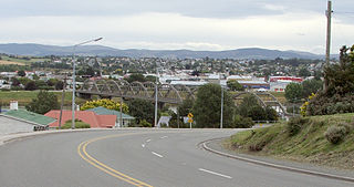
Balclutha is a town in South Otago, lying towards the end of the Clutha River, on the east coast of the South Island of New Zealand. It is about halfway between Dunedin and Gore on the Main South Line railway, State Highway 1 and the Southern Scenic Route. Balclutha has a population of 4,430, and is the largest town in South Otago.

Makarora is a small community within the Queenstown-Lakes District of the Otago region of the South Island of New Zealand.

West Otago is the local name given to part of the region of Otago, New Zealand, lying close to the border with Southland. It is administratively connected to South Otago, but is geographically separated from it by a range of hills known as the Blue Mountains. The largest settlements in West Otago are Tapanui and Heriot, and other localities within the area include Moa Flat, Edievale, Crookston, Merino Downs, and Waikoikoi. The area described as West Otago is sometimes extended to include Lawrence, Clinton, and Beaumont. The ghost town of Kelso also lies within West Otago. Other notable features of the area include Conical Hill and Landslip Hill, the latter being a major fossil-bearing formation.

<span class="mw-page-title-main">Albert Town, New Zealand</span> Town in Otago, New Zealand

Albert Town is located to the east of Wānaka in Otago, New Zealand. Until recently only a farming settlement, the population boom in this area has led to much new development. The confluence of the Clutha and Hāwea Rivers is located here. The town was named after Prince Albert of Saxe-Coburg and Gotha. Albert Town was formerly called Newcastle.

<span class="mw-page-title-main">Lake Roxburgh</span> Artificial lake in Otago Region, South Island

Lake Roxburgh is an artificial lake, created by the Roxburgh Dam, the earliest of the large hydroelectric projects in the southern South Island of New Zealand. It lies on the Clutha River, some 160 km (99 mi) from Dunedin. It covers an area of some 6 km2 (2.3 sq mi), and extends for nearly 30 km (19 mi) towards the town of Alexandra. The town of Roxburgh lies 5 kilometres (3.1 mi) south of the Dam.

<span class="mw-page-title-main">Queenstown-Lakes District</span> Territorial authority district in Otago, New Zealand

Queenstown-Lakes District, a local government district, is in the Otago Region of New Zealand that was formed in 1986. It is surrounded by the districts of Central Otago, Southland, Westland and Waitaki.

<span class="mw-page-title-main">Clutha District</span> Territorial authority district in Otago, New Zealand

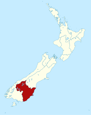
Clutha District is a local government district of southern New Zealand, with its headquarters in the Otago town of Balclutha. Clutha District has a land area of 6,334.47 km2 (2,445.75 sq mi) and an estimated population of 19,300 as of June 2024. Clutha District occupies the majority of the geographical area known as South Otago.

Dipton is a small town in the Southland region of New Zealand. It is located 20 kilometres south of Lumsden and 60 kilometres north of Invercargill. From 20 October 1875 until its closure on 13 December 1982, Dipton was situated on the Kingston Branch railway.

<span class="mw-page-title-main">Ettrick, New Zealand</span> Town in the South Island of New Zealand

Ettrick is a small town in inland Otago, in the South Island of New Zealand.

<span class="mw-page-title-main">Hawarden, New Zealand</span> Town in Canterbury, New Zealand

Hawarden is a small town in the Canterbury region of New Zealand's South Island. It is located near Waikari, just off State Highway 7.

<span class="mw-page-title-main">Cardrona, New Zealand</span> Rural locality in Otago, New Zealand

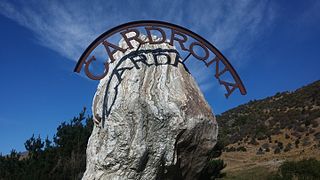
Cardrona is a locality in the Cardrona Valley in New Zealand, with the nearby skifield of Cardrona Alpine Resort and Mount Cardrona also using the same name. Established as a gold rush township in the 1860s on the banks of the small river of the same name, it is known for its distinctive hotel of gold rush vintage which is on the opposite side of the river to the original township of which few buildings remain. It is in a scenic setting on the Crown Range road which connects Wānaka and Queenstown.

<span class="mw-page-title-main">Upper Moutere</span> Rural locality in Tasman, New Zealand

Upper Moutere is a locality in the Tasman District near Motueka at the top of New Zealand's South Island.

<span class="mw-page-title-main">Waihola</span> Town in Otago, New Zealand

The township of Waihola lies between Dunedin and Milton, New Zealand in Otago, in New Zealand's South Island. It lies close to the southeast shore of the shallow tidal lake which shares its name.

<span class="mw-page-title-main">Wairau Valley</span> Valley and settlement in Marlborough, New Zealand

Wairau Valley is the valley of the Wairau River in Marlborough, New Zealand and also the name of the main settlement in the upper valley. State Highway 63 runs through the valley. The valley opens onto the Wairau Plain, where Renwick and Blenheim are sited. The Alpine–Wairau Fault runs along the length of the valley.

Stirling is a settlement in New Zealand. It is located in South Otago, approximately 5 km from Balclutha, and just north of the Matau Branch of the Clutha River.

Kopurererua is a rural community in the upper valley of the Kopurererua Stream in the Western Bay of Plenty District and Bay of Plenty Region of New Zealand's North Island. The lower Kopurererua valley is in Tauranga.

Clydevale is a township on the banks of the Clutha River / Mata-Au, in the Clutha Valley, 29 kilometres north-west of Balclutha.

Pisa Moorings is a small town in the Central Otago District of Otago region of New Zealand's South Island. It is located between Lake Dunstan on its east and State Highway 6 on its west. Cromwell is 9 km southwest and Wānaka is 45 km north by road.

Hāwea Flat is a rural settlement in the Queenstown-Lakes District of the South Island of New Zealand. Lake Hāwea is 5 km north. The area was named for Hāwea-i-te-raki, an ancestor of the Ngāti Hāwea hapū. The macron was officially added to the place name in 2010. It is located to the east of State Highway 6 between Albert Town and Lake Hāwea.

References

  1. 1 2 3 4 "ArcGIS Web Application". statsnz.maps.arcgis.com. Retrieved 14 December 2021.
  2. 1 2 "Aotearoa Data Explorer". Statistics New Zealand . Retrieved 26 October 2024.
  3. "Place name detail: Luggate". New Zealand Gazetteer. New Zealand Geographic Board . Retrieved 17 March 2018.
  4. Thornton, Geoffrey (2001). Bridging the Gap: Early Bridges in New Zealand 1830–1939. Auckland: Reed Publishing Ltd. p. 164.
  5. 1 2 "Statistical area 1 dataset for 2018 Census". Statistics New Zealand. March 2020. 7027954, 7027955 and 7027956.
  6. "Aotearoa Data Explorer". Statistics New Zealand . Retrieved 26 October 2024.
  7. 1 2 "Statistical area 1 dataset for 2018 Census". Statistics New Zealand. March 2020. Upper Clutha Valley (347200). 2018 Census place summary: Upper Clutha Valley