Related Research Articles

The Clutha River is the second longest river in New Zealand and the longest in the South Island. It flows south-southeast 338 kilometres (210 mi) through Central and South Otago from Lake Wānaka in the Southern Alps to the Pacific Ocean, 75 kilometres (47 mi) south west of Dunedin. Gold is in abundance in the Clutha River and its surrounding areas. It is the highest volume river in New Zealand, and has a discharging mean flow of 614 cubic metres per second (21,700 cu ft/s).

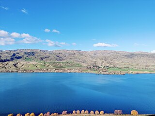
Lake Wānaka is New Zealand's fourth-largest lake and the seat of the town of Wānaka in the Otago region. The lake is 278 meters above sea level, covers 192 km2 (74 sq mi), and is more than 300 m (980 ft) deep.

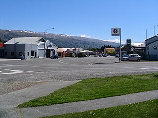
Cromwell is a town in Central Otago region of the South Island of New Zealand. Cromwell is located on the shores of Lake Dunstan where the Kawarau river joins Lake Dunstan. Cromwell was established during the Otago gold rush and is now more known as one of the sub regions of the Central Otago wine region. In 2018, the town of Cromwell was home to a population of 5610 people.

Wānaka is a popular ski and summer resort town in the Otago region of the South Island of New Zealand. At the southern end of Lake Wānaka, it is at the start of the Clutha River and is the gateway to Mount Aspiring National Park.

The Kawarau River is a river in the South Island of New Zealand. It drains Lake Wakatipu in northwestern Otago via the lake's Frankton Arm. The river flows generally eastwards for about 60 kilometres (37 mi) and passes through the steep Kawarau Gorge until it joins Lake Dunstan near Cromwell. Before the construction of the Clyde High Dam, the Kawarau joined the Clutha River / Mata-Au in a spectacular confluence at Cromwell. The Shotover River enters the Kawarau from the north; the Nevis River enters it from the south. With many rapids and strong currents, the river can be dangerous and has claimed many lives. It is popular for bungy jumping and kayaking.
The Cardrona River is in Otago in the South Island of New Zealand. It is one of the first tributaries of the Clutha River / Mata-Au, which it meets only 5 kilometres (3 mi) from the latter's origin at the outflow of Lake Wānaka.
The Cromwell Gorge is a steep gorge cut by the former Clutha River in the Central Otago region of New Zealand's South Island. It winds 19 km (12 mi) between the Dunstan and Cairnmuir Mountains, linking the townships of Cromwell and Clyde. It is one of three substantial river gorges in Central Otago, the others being the Kawarau Gorge to the west of Cromwell, and the Roxburgh Gorge south of Alexandra.

The Nevis River is in Otago, New Zealand. It flows north for 40 kilometres (25 mi) through rough country before meeting the Kawarau River, of which it is a tributary. A prominent rock outcrop close to this junction is known as the Nevis Bluff.
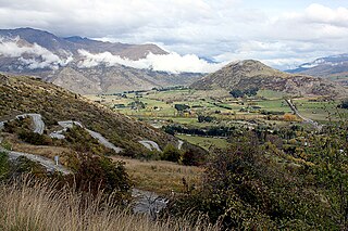
The Crown Range is a mountain range that lies to the east of the Wakatipu Basin in Otago, New Zealand. It is noted for two features, the Cardrona Alpine Resort, on the slopes of the 1900 metre Mount Cardrona, and a highway, known as the Crown Range Road, which winds steeply between Arrow Junction, just south of Arrowtown, and Wānaka to the north.

Lake Hāwea is New Zealand's ninth largest lake located on the South Island in the Otago Region at an altitude of 348 m. It covers 141 km2 and is 392 m deep.

The Central Otago wine region is a geographical indication in New Zealand's South Island, and the world's southernmost commercial wine growing region. While Central Otago is best known for Pinot Noir, many white wine varieties are also popular.
Blue Mountains are a range of rugged hills in West Otago, in southern New Zealand. They form a barrier between the valleys of the Clutha and Pomahaka Rivers. They lie between the towns of Tapanui and Lawrence and rise to 1019 metres (3280 ft).

The Roaring Meg hydro scheme refers to two small hydro electricity power stations fed by the Roaring Meg Dam. The scheme is located next to the Roaring Meg Stream in the Kawarau Gorge, near Cromwell, New Zealand. Roaring Meg is owned and operated by Pioneer Energy.

State Highway 8 is one of New Zealand's eight national highways. It forms an anticlockwise loop through the southern scenic regions of the Mackenzie Basin and Central Otago, starting and terminating in junctions with State Highway 1. Distances are measured from north to south.

State Highway 6 is a major New Zealand state highway. It extends from the Marlborough region in the northeastern corner of the South Island across the top of the island, then down the length of the island, initially along the West Coast and then across the Southern Alps through inland Otago and finally across the Southland Plains to the island's south coast. Distances are measured from north to south.

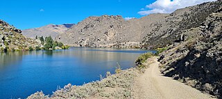
The Kawarau Gorge is a major river gorge created by the Kawarau River in Central Otago, in the South Island of New Zealand. The towns of Queenstown and Cromwell are linked by State Highway 6 through the gorge.

Luggate is a small town in the South Island of New Zealand. It is located on State Highway 6 between Wānaka and Cromwell, near the junction with State Highway 8A, approximately 15 km from the Wānaka township, just past Wānaka Airport. The town is nestled below the northern end of the Criffel Range of mountains.
The Old Man Range, also called Kopuwai, is a mountain range in Central Otago, in the South Island of New Zealand. It lies to the west of the valley of the Clutha River, close to the town of Alexandra and the artificial Lake Roxburgh. The range stretches north-south for a distance of some 40 kilometres (25 mi). Part of the range forms the border between the Otago and Southland Regions. The range's Māori name, Kopuwai, means "Water Swallower", and was the name of a mythical giant who lived in the area.

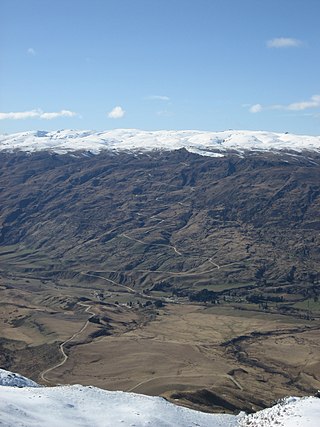
The Pisa Range is a mountain range in Central Otago, in the South Island of New Zealand. It lies on the western shore of the man-made Lake Dunstan and overlooks the town of Cromwell. Its highest point, Mount Pisa, is 1,963 m.
The Dunstan Mountains are a mountain range in Central Otago, in the South Island of New Zealand. The mountains lie on the eastern shore of the man-made Lake Dunstan and overlook the towns of Cromwell to the west, Clyde to the south and Omakau to the east. The highest named peak on the mountain range, a rocky knoll simply called Dunstan, is 1,667 m.
References
- ↑ "Pisa Range in Otago (Department of Conservation Document)". New Zealand Four Wheel Drive Association. 11 March 2008. Retrieved 28 December 2024.
- 1 2 "https://www.topomap.co.nz/NZTopoMap/nz20123/CRIFFEL-RANGE/ Criffel Range]", topomap.co.nz. Retrieved 28 December 2024.