Lake Hayes Estate

Last updated

Lake Hayes Estate
Town
Lakes Hayes Estate from The Remarkables.jpg
Lakes Hayes Estate from The Remarkables
Lake Hayes Estate
Coordinates: 45°00′02″S168°47′01″E / 45.000542°S 168.783592°E / -45.000542; 168.783592
CountryNew Zealand
Region Otago
Territorial authority Queenstown Lakes District
WardQueenstown-Wakatipu Ward
Government
  Local authority Queenstown-Lakes District Council
  Regional council Otago Regional Council
Area
[1]
  Total1.94 km2 (0.75 sq mi)
Elevation
332 m (1,089 ft)
Population
 (June 2022) [2]
  Total2,470
  Density1,300/km2 (3,300/sq mi)
Time zone UTC+12 (NZST)
  Summer (DST) UTC+13 (NZDT)
Postal Code
9304
Area code03
Local iwi Ngāi Tahu
Stone sign at the entrance Lakes Hayes Estate sign.jpg
Stone sign at the entrance

Lake Hayes Estate (often shortened to LHE) is a town nearby to Queenstown in the South Island of New Zealand. It is named after and situated near Lake Hayes; however, the lake is not visible from most parts of the estate. The population of the town at the 2018 census was 2,470. The main access to Lake Hayes Estate is off State Highway 6. To the west is the newer sub division of Shotover Country which can be accessed via Jones Road.

Contents

Lake Hayes Estate was one of the first residential areas of a large scale involving quite flat land near Queenstown, meaning sections were quite sought after. The original 700 sections have virtually all been built on. In 2012 work began on a sub division bordering Lake Hayes Estate called Hayes Creek and by 2016 all of these sections had been sold.

History

For a long time, the area was known as Douglasvale but once residential development began around 1990 by Lake Hayes Estate Ltd it was officially given its current name. [3]

Demographics

Statistics New Zealand describes Lake Hayes as a small urban area comprising Shotover Country, Lake Hayes Estate and Lake Hayes statistical area. The urban area covers 10.90 km2 (4.21 sq mi) [1] and had an estimated population of 6,760 as of June 2022, [4] with a population density of 620 people per km2.

Lake Hayes Estate

Lake Hayes Estate covers 1.94 km2 (0.75 sq mi) [1] and had an estimated population of 2,470 as of June 2022, [2] with a population density of 1,273 people per km2.

Historical population of Lake Hayes Estate
YearPop.±% p.a.
2006570    
20131,599+15.88%
20182,139+5.99%
Source: [5]

Lake Hayes Estate had a population of 2,139 at the 2018 New Zealand census, an increase of 540 people (33.8%) since the 2013 census, and an increase of 1,569 people (275.3%) since the 2006 census. There were 585 households. There were 1,077 males and 1,062 females, giving a sex ratio of 1.01 males per female. The median age was 32.4 years (compared with 37.4 years nationally), with 573 people (26.8%) aged under 15 years, 417 (19.5%) aged 15 to 29, 1,071 (50.1%) aged 30 to 64, and 78 (3.6%) aged 65 or older.

Ethnicities were 82.9% European/Pākehā, 6.6% Māori, 1.7% Pacific peoples, 12.3% Asian, and 4.8% other ethnicities (totals add to more than 100% since people could identify with multiple ethnicities).

The proportion of people born overseas was 32.0%, compared with 27.1% nationally.

Although some people objected to giving their religion, 63.7% had no religion, 26.6% were Christian, 1.8% were Hindu, 0.7% were Muslim, 0.8% were Buddhist and 2.4% had other religions.

Of those at least 15 years old, 411 (26.2%) people had a bachelor or higher degree, and 126 (8.0%) people had no formal qualifications. The median income was $45,200, compared with $31,800 nationally. 399 people (25.5%) earned over $70,000 compared to 17.2% nationally. The employment status of those at least 15 was that 1,089 (69.5%) people were employed full-time, 255 (16.3%) were part-time, and 24 (1.5%) were unemployed. [5]

Lake Hayes

The Lake Hayes statistical area covers 5.93 km2 (2.29 sq mi) [1] of rural area to the north, east and south of the eponymous Lake Hayes. It had an estimated population of 400 as of June 2022, [2] with a population density of 67 people per km2.

Historical population of Lake Hayes statistical area
YearPop.±% p.a.
2006252    
2013318+3.38%
2018354+2.17%
Source: [6]

Lake Hayes had a population of 354 at the 2018 New Zealand census, an increase of 36 people (11.3%) since the 2013 census, and an increase of 102 people (40.5%) since the 2006 census. There were 132 households. There were 180 males and 174 females, giving a sex ratio of 1.03 males per female. The median age was 49.0 years (compared with 37.4 years nationally), with 57 people (16.1%) aged under 15 years, 36 (10.2%) aged 15 to 29, 198 (55.9%) aged 30 to 64, and 63 (17.8%) aged 65 or older.

Ethnicities were 93.2% European/Pākehā, 5.9% Māori, 2.5% Asian, and 1.7% other ethnicities (totals add to more than 100% since people could identify with multiple ethnicities).

The proportion of people born overseas was 23.7%, compared with 27.1% nationally.

Although some people objected to giving their religion, 51.7% had no religion, 44.1% were Christian and 2.5% had other religions.

Of those at least 15 years old, 99 (33.3%) people had a bachelor or higher degree, and 15 (5.1%) people had no formal qualifications. The median income was $52,400, compared with $31,800 nationally. 111 people (37.4%) earned over $70,000 compared to 17.2% nationally. The employment status of those at least 15 was that 156 (52.5%) people were employed full-time, 45 (15.2%) were part-time, and 3 (1.0%) were unemployed. [6]

Shops and Affordable Housing

Nerin Square is a large roundabout situated in the centre of the estate.

In 2014 the first shops appeared in Lake Hayes Estate within Nerin Square which consisted of a restaurant, bar and general store.

A large affordable [7] housing development called Nerin Square is next to McBride Park. It was set up by the Queenstown Lakes Community Housing Trust to help locals into their own homes due to the general affordability of housing in the Queenstown region. Nerin Square was the first major development for the trust, which built 27 homes in the centre of Lake Hayes Estate.

In October 2022, Environment Minister David Parker announced that the New Zealand Government had fast-tracked the Te Pūtahi project at Lake Hayes to build 748 more homes, a public transport area, and a possible school. [8]

McBride Park

McBride Park is one of the central points of the estate and was named after a family of industrious settlers who first lived on the land. [9] In the centre of the estate is a large grassed park which is surrounded by a bike park and bike pump track made of asphalt. There is a mini multi-purpose turf near Onslow Road which is used for basketball, hockey, tennis and football. There is also a large children's playground next to Hope Avenue which includes a variety of activities available including a flying fox and a climbing rock. There is also a public barbecue incorporated with the playground.

Public Tracks

There are a large number of public trails that circle the estate and allow good access throughout the suburb. They are used by walkers, runners and cyclists and connect to the much larger Queenstown Trail. The Lake Hayes Circuit track connects with Lake Hayes to the north via Ada Place. The Twin Rivers Ride to the south connects to Frankton and Gibbston and is accessed via Widgeon Place. The nearby subdivision of Shotover Country to the is linked via the trail network to Lake Hayes Estate.

Related Research Articles

<span class="mw-page-title-main">Queenstown, New Zealand</span> Resort town in Otago, New Zealand

Queenstown is a resort town in Otago in the south-west of New Zealand's South Island. It has an urban population of 15,800.

<span class="mw-page-title-main">Arrowtown</span> Town in Otago, New Zealand

Arrowtown is a historic gold mining town in the Otago region of the South Island of New Zealand. Arrowtown is located on the banks of the Arrow River approximately 7.5 km from State Highway 6. Arrowtown is located 19.5 kilometres to the east of Queenstown. As well as the route via State Highway 6 at Arrow Junction, there is also road access directly to Queenstown via Arthurs Point and a third route via the picturesque Lake Hayes.

<span class="mw-page-title-main">Te Anau</span> Town in Southland, New Zealand

Te Anau is a town in the Southland region of the South Island of New Zealand. In Maori, Te-Anau means the Place of the Swirling Waters. It is on the eastern shore of Lake Te Anau in Fiordland. Te Anau is 155 kilometres north of Invercargill and 171 kilometres to the southwest of Queenstown. Manapouri lies 21 kilometres to the south. Te Anau lies at the southern end of the Milford Road, 117 kilometres to the south of Milford Sound.

<span class="mw-page-title-main">Clyde, New Zealand</span> Town in Otago, New Zealand

Clyde, formerly Dunstan, is a small town in Central Otago, New Zealand with a population of 1,270 in June 2022. It is located on the Clutha River, between Cromwell and Alexandra.

<span class="mw-page-title-main">Tapawera</span> Settlement in Tasman District, New Zealand

Tapawera is a small town in the Tasman District of New Zealand's South Island. It is located 76 km southwest of Nelson and 48 km southeast of Motueka. It is situated on the Motueka Valley Highway by the banks of the Motueka River.

<span class="mw-page-title-main">Renwick, New Zealand</span> Place in Marlborough, New Zealand

Renwick is a small town in Marlborough, New Zealand, close to the south bank of the Wairau River. It is located on State Highway 6, 12 kilometres (7 mi) west of Blenheim. Havelock is 31 km (19 mi) north. State Highway 63 runs southwest from Renwick through the Wairau River valley.

<span class="mw-page-title-main">Queenstown-Lakes District</span> Territorial authority district in Otago, New Zealand

Queenstown-Lakes District, a local government district, is in the Otago Region of New Zealand that was formed in 1986. It is surrounded by the districts of Central Otago, Southland, Westland and Waitaki.

<span class="mw-page-title-main">Clutha District</span> Territorial authority district in Otago, New Zealand

Clutha District is a local government district of southern New Zealand, with its headquarters in the Otago town of Balclutha. Clutha District has a land area of 6,334.47 km2 (2,445.75 sq mi) and an estimated population of 18,650 as of June 2022. Clutha District occupies the majority of the geographical area known as South Otago.

<span class="mw-page-title-main">Taupō District</span> District in New Zealand

Taupō District is a territorial authority district in New Zealand. It covers 6,333 km² of land, and a further 610 km² of lake area, including Lake Taupō, New Zealand's largest lake, and Lake Rotoaira. The district stretches from the small town of Mangakino in the northwest to the Tongariro National Park in the south, and east into the Kaingaroa Forest. The district's population is largely located in the two main centres, Taupō and Tūrangi.

<span class="mw-page-title-main">Frankton, Otago</span> Suburb in Queenstown, New Zealand

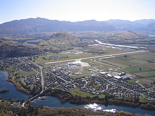
Frankton is a suburb of the town of Queenstown in the South Island of New Zealand, it was formerly a separate settlement.

<span class="mw-page-title-main">Pukawa</span> Settlement in Waikato, New Zealand

Pukawa or Pukawa Bay is a bay and a small township on the southern shores of Lake Taupo on New Zealand's North Island. It is off State Highway 41 between Turangi and Taumarunui, in the Taupo District and Waikato region.

<span class="mw-page-title-main">Ashburton District</span> Territorial authority district in Canterbury, New Zealand

Ashburton District is a territorial authority district in the Canterbury Region of the South Island of New Zealand. It encompasses the town of Ashburton, a number of small towns and settlements and the surrounding rural area, roughly coterminous with Mid Canterbury. The district had a population of 36,300 as of June 2022.

<span class="mw-page-title-main">Wakatipu Basin</span>

The Whakatipu Basin is a plain surrounded by mountains in Queenstown Lakes District, in the southern South Island of New Zealand.

<span class="mw-page-title-main">Gibbston</span> Community in Otago, New Zealand

Gibbston is a community in the Wakatipu Basin in the Otago region of the South Island, New Zealand. Through the valley runs the Kawarau River which forms the Kawarau Gorge.

<span class="mw-page-title-main">Arthurs Point</span> Suburb in Queenstown, New Zealand

Arthurs Point is a suburb of Queenstown in the South Island of New Zealand. It is situated near Queenstown Hill and Bowen Peak and is not far from central Queenstown. Another distinctive aspect for the area is that the Shotover Jet company operates jetboats on the Shotover River which passes under the Edith Cavell Bridge.

<span class="mw-page-title-main">Jack's Point</span> Residential subdivision in Central Otago, New Zealand

Jack's Point is a luxury estate in Central Otago, New Zealand, covering 1,200 hectares of land. It is located 6 km south of Queenstown, at the foot of The Remarkables and close to the edge of Lake Wakatipu. It is known for its golf course. It is rated among the top 10 lifestyle estates in the world.

<span class="mw-page-title-main">Shotover Country</span> Suburb in Queenstown, New Zealand

Shotover Country is a suburb of Queenstown in the South Island of New Zealand. It has around 810 sections and was originally 202 hectares when first rezoned from rural to residential. The suburb began in 2012 when sections first came up for sale.

<span class="mw-page-title-main">Kelvin Peninsula</span> Suburb of the town of Queenstown in the South Island of New Zealand

Kelvin Peninsula is a peninsula on the shore of Lake Wakatipu in New Zealand's Otago Region. The peninsula lies between the main body of Lake Wakatipu and the lake's Frankton Arm and its outlet, the Kawarau River. The centre of Queenstown lies on the opposite shore of the Frankton Arm. The peninsula was formerly called Kelvin Heights Peninsula. The name Kelvin Heights is still used for the Queenstown suburb which sits on the peninsula.

<span class="mw-page-title-main">Sandspit, New Zealand</span> Suburb in Auckland, New Zealand

Sandspit is a settlement in the Auckland Region of New Zealand. It is on the Mahurangi Peninsula, about 65 kilometres north of the city centre. It has experienced substantial increases in property values during the first two decades of the 21st century.

<span class="mw-page-title-main">Waiomu</span> Rural settlement in New Zealand

Waiomu is a settlement on the west coast of the Coromandel Peninsula of New Zealand, between Tapu to the north and Te Puru to the south. State Highway 25 runs through it.

References

  1. 1 2 3 4 "ArcGIS Web Application". statsnz.maps.arcgis.com. Retrieved 23 December 2021.
  2. 1 2 3 "Population estimate tables - NZ.Stat". Statistics New Zealand . Retrieved 25 October 2022.
  3. "LAKE HAYES ESTATE TOWNSHIP DEVELOPMENT". Clark Fortune McDonald & Associates. Archived from the original on 7 February 2013. Retrieved 23 December 2013.
  4. "Subnational population estimates (RC, SA2), by age and sex, at 30 June 1996-2022 (2022 boundaries)". Statistics New Zealand . Retrieved 25 October 2022. (regional councils); "Subnational population estimates (TA, SA2), by age and sex, at 30 June 1996-2022 (2022 boundaries)". Statistics New Zealand . Retrieved 25 October 2022. (territorial authorities); "Subnational population estimates (urban rural), by age and sex, at 30 June 1996-2022 (2022 boundaries)". Statistics New Zealand . Retrieved 25 October 2022. (urban areas)
  5. 1 2 "Statistical area 1 dataset for 2018 Census". Statistics New Zealand. March 2020. Lake Hayes Estate (348800). 2018 Census place summary: Lake Hayes Estate
  6. 1 2 "Statistical area 1 dataset for 2018 Census". Statistics New Zealand. March 2020. Lake Hayes (348500). 2018 Census place summary: Lake Hayes
  7. "NERIN SQUARE - A SPECIAL SENSE OF PLACE". qlcht.org.nz. © 2010 Housing Trust. Retrieved 12 August 2015.
  8. "Te Pūtahi, 748-home project in Queenstown approved for RMA fast-track". Radio New Zealand . 17 October 2022. Archived from the original on 8 February 2023. Retrieved 28 March 2023.
  9. "McBride Park". Leisure & Culture/Parks and Walkways/Wakatipu Parks and Gardens. Queenstown Lakes District Council. Archived from the original on 12 August 2010. Retrieved 7 February 2014.