Related Research Articles
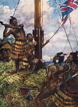
The Flagstaff War, also known as Heke's War, Hōne Heke's Rebellion and the Northern War, was fought between 11 March 1845 and 11 January 1846 in and around the Bay of Islands, New Zealand. The conflict is best remembered for the actions of Hōne Heke who challenged the authority of the British by cutting down the flagstaff on Flagstaff Hill at Kororāreka. The flagstaff had been a gift from Hōne Heke to James Busby, the first British Resident. The Northern War involved many major actions, including the Battle of Kororāreka on 11 March 1845, the Battle of Puketutu on 8 May 1845, the Battle of Ōhaeawai on 23 June 1845 and the siege of Ruapekapeka Pā from 27 December 1845 to 11 January 1846.
The First Taranaki War was an armed conflict over land ownership and sovereignty that took place between Māori and the New Zealand government in the Taranaki district of New Zealand's North Island from March 1860 to March 1861.
The Second Taranaki War is a term used by some historians for the period of hostilities between Māori and the New Zealand Government in the Taranaki district of New Zealand between 1863 and 1866. The term is avoided by some historians, who either describe the conflicts as merely a series of West Coast campaigns that took place between the Taranaki War (1860–1861) and Titokowaru's War (1868–69), or an extension of the First Taranaki War.
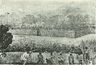
The Battle of Ōhaeawai, part of the Flagstaff War, was fought in July 1845 at Ōhaeawai in Northland, New Zealand. The battle was between British forces and their allies from the local Ngāpuhi tribe of Māori on one side, and other Ngāpuhi, led by Te Ruki Kawiti, a prominent rangatira (chief), on the other side. The battle was notable for establishing that an appropriately built fortified pā could withstand bombardment from cannon fire, with a frontal assault by soldiers suffering heavy casualties.

Tāmati Wāka Nene was a Māori rangatira (chief) of the Ngāpuhi iwi (tribe) who fought as an ally of the British in the Flagstaff War of 1845–46.
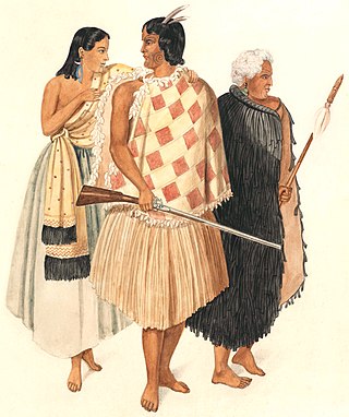
Te Ruki Kawiti was a prominent Māori rangatira (chief). He and Hōne Heke successfully fought the British in the Flagstaff War in 1845–46.

Hōne Wiremu Heke Pōkai, born Heke Pōkai and later often referred to as Hōne Heke, was a highly influential Māori rangatira (chief) of the Ngāpuhi iwi (tribe) and a war leader in northern New Zealand; he was affiliated with the Ngati Rahiri, Ngai Tawake, Ngati Tautahi, Te Matarahurahu and Te Uri-o-Hua hapū (subtribes) of Ngāpuhi. Hōne Heke fought with Hongi Hika, an earlier war leader of the Ngāpuhi, in the Musket Wars. Hōne Heke is considered the principal instigator of the Flagstaff War in 1845–46.

Arrowtown is a historic gold mining town in the Otago region of the South Island of New Zealand. Arrowtown is located on the banks of the Arrow River approximately 7.5 km from State Highway 6. Arrowtown is located 19.5 kilometres to the east of Queenstown. As well as the route via State Highway 6 at Arrow Junction, there is also road access directly to Queenstown via Arthurs Point and a third route via the picturesque Lake Hayes.

The Otago gold rush was a gold rush that occurred during the 1860s in Central Otago, New Zealand. This was the country's biggest gold strike, and led to a rapid influx of foreign miners to the area – many of them veterans of other hunts for the precious metal in California and Victoria, Australia. The number of miners reached its maximum of 18,000 in February 1864.
Heritage New Zealand Pouhere Taonga is a Crown entity with a membership of around 20,000 people that advocates for the protection of ancestral sites and heritage buildings in New Zealand. It was set up through the Historic Places Act 1954 with a mission to "...promote the identification, protection, preservation and conservation of the historical and cultural heritage of New Zealand" and is an autonomous Crown entity. Its current enabling legislation is the Heritage New Zealand Pouhere Taonga Act 2014.
Point Britomart was a headland in the Waitematā Harbour, in Auckland, New Zealand. Located between Commercial Bay and Official Bay, the point was later quarried away to produce fill for land reclamation in Mechanics Bay, and almost no physical trace remains at street level in what is today an area of the Auckland CBD and the Auckland waterfront.
The following lists events that happened during 1869 in New Zealand.

Quarry Hill is a suburb of Bendigo, Victoria, Australia 3 kilometres (1.9 mi) south of the Bendigo city centre. At the 2016 census, Quarry Hill had a population of 2,339.
John Lawn was a New Zealand goldminer and mine manager. He was born in Gwennap, Cornwall, England on 4 November 1840.
Manuherikia is a genus of extinct species of ducks from the Miocene of New Zealand. It was described from fossil material of the Saint Bathans Fauna, in the lower Bannockburn Formation of the Manuherikia Group, found by the Manuherikia River in the Central Otago region of the South Island. The genus name comes from the name of the geological formation in which the fossils were found and, ultimately, from the Manuherikia River and its valley.
Scenic reserves are a type of New Zealand protected area. They are the most common, and probably most widespread, form of protected area in the country. The reserve vary size: while most are less than 100 hectares, some are more than 1,000 hectares. Some are "islands of unspoilt nature in a sea of farmland".
A recreation reserve is a type of New Zealand protected area owned by the New Zealand Government and reserved mainly for sporting or recreational activities. Many provide public access to coastlines, lakes and rivers. Some are administered by the Department of Conservation.
The Bendigo Goldfields region of Central Otago is an historic area comprising several former mining settlements in the southern South Island of New Zealand. It was part of the Otago gold rush that occurred during the 1860s, leading to an influx of miners from rushes in California and Victoria, Australia. These miners brought with them a rich diversity of cultures from England, Scotland, Wales, Ireland, Sweden, China, Australia, Canada, and the United States. The area was named after the goldfield by the same name in Victoria.

Cambrians, or Cambrian, formerly known as Dunstan Creek and Welshman's Gully, is a small rural settlement in the Manuherikia Valley, Central Otago, New Zealand.