
The Spencer Gulf is the westernmost and larger of two large inlets on the southern coast of Australia, in the state of South Australia, facing the Great Australian Bight. It spans from the Cape Catastrophe and Eyre Peninsula in the west to Cape Spencer and Yorke Peninsula in the east.

Te Waewae Bay is the westernmost of three large bays lying on the Foveaux Strait coast of Southland, New Zealand, the others being Oreti Beach and Toetoes Bay. Twenty-seven kilometres in length, the western end of the bay is mountainous, with the southern terminus of the Southern Alps and Fiordland National Park.

New Zealand has 44 marine reserves spread around the North, the South Island, and neighbouring islands, and on outlying island groups. They are governed by the Marine Reserves Act 1971 and administered by the Department of Conservation with assistance from the Ministry for Primary Industries, New Zealand Customs Service and the New Zealand Defence Forces.

Te Whanganui-A-Hei Marine Reserve is in the southern part of Mercury Bay on the Coromandel Peninsula in New Zealand covering an area of 840 hectares. On the coast of the mainland, it stretches from Cook Bluff in the north-west to the northern end of Hahei Beach in the south-east. Its offshore extremes run from Motukorure Island through Waikaranga Island to Okorotere Island and the northern end of Mahurangi Island.
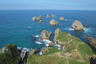
Nugget Point is one of the most iconic landforms on the Otago coast in New Zealand. Located at the northern end of the Catlins coast, along the road from Kaka Point, this steep headland has a lighthouse at its tip, surrounded by rocky islets. The point is home to many seabirds, including penguins, gannets and royal spoonbills, and a large breeding colony of fur seals. Roaring Bay, on the south coast of the tip of Nugget Point, is home to a small colony of yellow-eyed penguins.
The Five Islands Nature Reserve is a protected nature reserve located in the Tasman Sea, off the Illawarra east coast of the state of New South Wales, Australia. The 26-hectare (64-acre) reserve comprises five continental islands that are situated between 0.5 and 3.5 kilometres east of Port Kembla. The Five Islands are Flinders Islet, Bass Islet, Martin Islet, Big Island and Rocky Islet.
The Open Bay Islands are located in South Westland, off the south-west coast of the South Island of New Zealand. They consist of two main islands, Taumaka and Popotai, plus several smaller islets and rocks. They lie approximately 5 km (3.1 mi) offshore from the Okuru River mouth, near Haast, and are owned by the West Coast branch Māori iwi Ngāi Tahu known as Poutini Ngāi Tahu.
Kapiti Marine Reserve is a protected area on two sides of Kapiti Island, off the southern west coast of the North Island of New Zealand. It was created in 1992.

Solitary Islands Marine Park (SIMP) is a marine park in New South Wales State waters, Australia. It adjoins the Solitary Islands Marine Reserve and was declared under the Marine Parks Act 1997 (NSW) in January 1998. Prior to this it was declared a marine reserve in 1991. The Park was one of the first declared in NSW and stretches along the northern NSW coast, from Muttonbird Island, Coffs Harbour, to Plover Island near Sandon River, 75 kilometres to the north. It includes coastal estuaries and lakes and extends from the mean high water mark, to three nautical miles out to sea, covering an area of around 72,000 hectares. There are five main islands in the Park, North Solitary Island, North West Solitary Island, South West Solitary Island, South Solitary Island and Split Solitary Island, as well as other significant outcrops such as Muttonbird Island and submerged reefs.
Hawea Marine Reserve is a marine reserve covering an area of 411 hectares in Hāwea / Bligh Sound, in Fiordland on New Zealand's South Island. It was established in 2005 and is administered by the Department of Conservation.

Ulva Island-Te Wharawhara Marine Reserve is a marine reserve covering an area of 1,075 hectares south-west and north-east of Ulva Island, in the Paterson Inlet of New Zealand's Stewart Island. It was established in 2004 and is administered by the Department of Conservation.

Hikurangi Marine Reserve is a marine reserve off the coast of the Kaikōura District, in the Canterbury Region of New Zealand's South Island. It is the largest and deepest marine reserve in New Zealand.

Waiau Glacier Coast Marine Reserve is a marine reserve of the West Coast Region of New Zealand's South Island. It covers an area of 4,641 hectares or 46 km2, from 11 km south from Kohuamarua Bluff near Ōkārito, to Omoeroa Bluff, and about 4 km out to sea.

Moutere Ihupuku / Campbell Island Marine Reserve or Campbell Island / Moutere Ihupuku Marine Reserve is a marine reserve around Campbell island in the New Zealand Subantarctic Islands.

Kahurangi Marine Reserve is a marine reserve administered by the Department of Conservation, covering 8,419 hectares offshore of Kahurangi National Park in the Buller District of New Zealand's West Coast Region.

Punakaiki Marine Reserve is a marine reserve administered by the Department of Conservation. The reserve includes the area of sea surrounding the pancake rocks and blowholes at Dolomite Point, at Punakaiki on the West Coast Region of New Zealand's South Island. It also includes most of the coastline on the western edge of Paparoa National Park.

Tauparikākā Marine Reserve is a marine reserve located offshore about 20 kilometres (12 mi) north of Haast on the West Coast of New Zealand's South Island. It covers the area immediately offshore from Ship Creek, which is also known as Tauparikākā in Māori.
Moutere Mahue / Antipodes Island Marine Reserve is a marine reserve covering an area of 217,287 hectares around the Antipodes Islands south of New Zealand's South Island and Stewart Island / Rakiura. It was established in 2014 and is administered by the New Zealand Department of Conservation.
Moutere Hauriri / Bounty Islands Marine Reserve is a marine reserve covering an area of 104,626 hectares around New Zealand's Bounty Islands. It was established in 2014 and is administered by the Department of Conservation.
Kahukura Marine Reserve is a marine reserve covering an area of 464 hectares in Charles Sound, in Fiordland on New Zealand's South Island. It was established in 2005 and is administered by the Department of Conservation.

