
The national parks of New Zealand are protected areas administered by the Department of Conservation. Although the national parks contain some of New Zealand's most beautiful scenery, the first few established were all focused on mountain scenery. Since the 1980s the focus has been on developing a more diverse representation of New Zealand landscapes. The parks are all culturally significant and many also contain historic features. Tongariro National Park is one of the World Heritage Sites that are of both cultural and natural significance, while four of the South Island national parks form Te Wahipounamu, another World Heritage Site. There are currently 13 national parks; a 14th, Te Urewera National Park, was disestablished in 2014.

The Kaimai Range is a mountain range in the North Island of New Zealand. It is part of a series of ranges, with the Coromandel Range to the north and the Mamaku Ranges to the south. The Kaimai Range separates the Waikato in the west from the Bay of Plenty in the east.

Hemi Topine Te Mamaku was a Māori chief in the Ngāti Hāua-te-rangi iwi from the Whanganui region of New Zealand's North Island.

Kahurangi National Park in the northwest of the South Island of New Zealand is the second largest of the thirteen national parks of New Zealand. It was gazetted in 1996 and covers 4,529 square kilometres (1,749 sq mi), ranging to near Golden Bay in the north. Much of what was the North-west Nelson Forest Park formed the basis of the new park. Kahurangi Point, regarded as the boundary between the West Coast and Tasman Regions, is located in the park, as are the Heaphy Track and Mount Owen.

Mount Aspiring National Park is in the Southern Alps of the South Island of New Zealand, north of Fiordland National Park, situated in Otago and Westland regions. The park forms part of the Te Wahipounamu World Heritage site.

The Whanganui National Park is a national park located in the North Island of New Zealand. Established in 1986, it covers an area of 742 km² bordering the Whanganui River. It incorporates areas of Crown land, former state forest and a number of former reserves. The river itself is not part of the park.
The Mamaku Ranges are a range of rugged hills in the North Island of New Zealand. Located to the west of Lake Rotorua and north of Lake Taupo, they lie to the immediate south of the Kaimai Range and can be thought of as an extension of it, in much the same way that the Kaimai Range can be considered an extension of the Coromandel Range. The hills terminate in the south with the valley of the Waikato River. There were at one time numerous bush railways that ran over and through the Ranges.

The Karangahake Gorge lies between the Coromandel and Kaimai ranges, at the southern end of the Coromandel Peninsula in New Zealand's North Island. A sharply winding canyon, it was formed by the Ohinemuri River. State Highway 2 passes through this gorge between the towns of Paeroa, Waikino and Waihi. This road is the main link between the Waikato region and the Bay of Plenty.
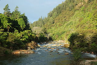
The Ohinemuri River is located in the northern half of New Zealand's North Island, at the base of the Coromandel Peninsula.

Conservation in New Zealand has a history associated with both Māori and Europeans. Both groups of people caused a loss of species and both altered their behaviour to a degree after realising their effect on indigenous flora and fauna.
Conservation park is a type of specially protected status for land held by the Crown in New Zealand for conservation purposes. The status is set up under the Conservation Act 1987 and the parks are administered by the Department of Conservation (DoC).

Tramping, known elsewhere as backpacking, rambling, hill walking or bushwalking, is a popular activity in New Zealand.
The Rotorua Branch is a railway line from Putaruru to Rotorua, in the Waikato and Bay of Plenty regions of the North Island of New Zealand. Construction of the line was commenced by the Thames Valley and Rotorua Railway Company and finished by the Public Works Department. The complete line, 50.5 kilometres (31.4 mi) in length, opened in two sections; on 24 November 1893 to Tarukenga and the final 8 mi 43 ch (13.7 km) to Rotorua on 8 December 1894.

Wairere Falls, the highest waterfall in New Zealand's North Island, plunges 153 metres (500 feet) in two steps over the Kaimai escarpment.
The Opuiaki River is a river of the Bay of Plenty Region of New Zealand's North Island. It flows north from the Mamaku Plateau into Lake McLaren, to reach the Wairoa River 15 kilometres (9 mi) southwest of Tauranga. The river contributes to the Kaimai Hydro power scheme built in the 1980s. A dam was built up hill from where the Ngatuhoa Lodge is now located. From the dam a tunnel was dug,which channels the water into the Ngatuhoa Stream, where it enters just above another dam built there. Provisions are made to maintain some flow in both streams. Digging the tunnel was a challenging operation due to the geology of the area, formed by volcanic activity from various volcanoes, with clay and other sediment in between. Artesian waters also flow between the layers of rock and contribute to the flow of the streams in the area.

The Mangapapa River is a river of the Bay of Plenty Region of New Zealand's North Island. It rises on the north slopes of the Mamaku Plateau at the southern end of the Kaimai Range and meets the Opuiaki River at the head of Lake McLaren, which discharges to the Wairoa River a short distance downstream from the lake at the confluence with the Mangakarengorengo River.
The Waipapa River is a river of the western Bay of Plenty Region of New Zealand's North Island. It flows generally north from its origins in Kaimai Mamaku Forest Park to reach Tauranga Harbour 12 kilometres (7 mi) west of Tauranga.

Indian Island is an island in Dusky Sound in Fiordland. Its name stems from first sightings of indigenous people on the island by James Cook in 1773.

The Mountain Rimu Timber Company owned and operated a bush railway near Mamaku south of the Kaimai Range near Rotorua in the Bay of Plenty Region of the North Island of New Zealand. The tramway with a track gauge of 3 1⁄2 feet (1,067 mm) was used from approximately 1898 to at least 1935.


