
The Sabine River is in the South Island of New Zealand. It is located in Nelson Lakes National Park.

The Travers River is in the South Island of New Zealand.

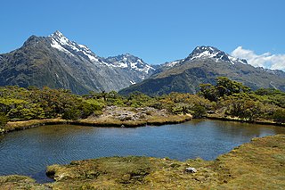
Nelson Lakes National Park is in the South Island of New Zealand, at the northern end of the Southern Alps. It was created in 1956. The park contains beech forests, multiple lakes, snow-covered mountains and valleys created by glaciers during the ice ages.

Kahurangi National Park in the northwest of the South Island of New Zealand is the second largest of the thirteen national parks of New Zealand. It was gazetted in 1996 and covers 5,193 km2 (2,005 sq mi), ranging from the Buller River near Murchison in the south, to the base of Farewell Spit in Golden Bay in the north. The park has no single dominant landform, but includes an unusually wide variety of landscapes, including mountain ranges, rivers, gorges, raised peneplains and karst features such as caves and arches. Many of the landforms within the park are considered to be nationally or internationally significant.

Arthur's Pass National Park is located in the South Island of New Zealand and covers 1,185 km2 of mostly mountainous terrain. Adjacent to it lies Craigieburn Forest Park. The park is administered by the Department of Conservation.
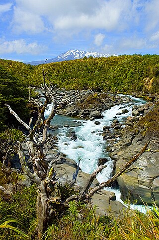
Tongariro National Park is the oldest national park in New Zealand, located in the central North Island. It has been acknowledged by UNESCO as a World Heritage Site of mixed cultural and natural values.

The Heaphy Track is a popular tramping and mountain biking track in the north west of the South Island of New Zealand. It is located within the Kahurangi National Park and classified as one of New Zealand's ten Great Walks by the Department of Conservation. Named after Charles Heaphy, the track is 78.4 kilometres (48.7 mi) long and is usually walked in four or five days. The track is open for shared use with mountain bikers in the winter season from 1 May to 30 September each year. The southern end of the track is at Kōhaihai, north of Karamea on the northern West Coast, and the northern end is in the upper valley of the Aorere River, Golden Bay.
The Routeburn Track is a world-renowned, 32 km tramping (hiking) track found in the South Island of New Zealand. The track can be done in either direction, starting on the Queenstown side of the Southern Alps, at the northern end of Lake Wakatipu or on the Te Anau side, at the Divide, several kilometres from the Homer Tunnel to Milford Sound.

The Matukituki River is a short braided river in the Southern Alps of New Zealand's South Island. Both its West Branch and East Branch originate from the Main Divide mountain ranges near Mount Aspiring / Tititea. Their largely glacier-fed waters each flow for approximately 20 kilometres (12 mi) before joining near Camerons Flat. After this confluence, the Matukituki River leaves the boundaries of Mount Aspiring National Park and continues for another 30 kilometres (19 mi) to exit into Lake Wānaka at the lake's southwestern edge.

Lake Ōhau is a lake in the Mackenzie Basin in the South Island of New Zealand. The Hopkins and Dobson rivers fed into the northern end of Lake Ōhau. These rivers have their headwaters in the Southern Alps. The lake's outflow is the Ōhau River, which travels from the southeast corner of Lake Ōhau and feeds into the Waitaki River hydroelectric project. The Barrier range dominate the western side of Lake Ōhau, while the Ben Ohau range dominates the eastern side of Lake Ōhau. At the northern end of the lake, in between the Hopkins and Dobson rivers, lies the Naumann Range of mountains.

The Tararua Range, often referred to as the Tararua Ranges or Tararua, is one of several mountain ranges in the North Island of New Zealand.
Broken River is a club skifield in South Island, New Zealand. Run by the Broken River Ski Club, it is located at about 110 km (68 mi) from Christchurch. The skifield claims to often have the longest ski season anywhere in Australasia. Also, by connecting with Craigieburn Valley, it claims to have the largest skiable area in New Zealand, at 900 hectares.

Craigieburn Valley Ski Area is a club skifield in the Southern Alps of New Zealand's South Island, about 104 km west from Christchurch. Catering only to intermediate and advanced skiers, it features a vertical range of 1308–1811 m, 400 Acres of skiable area and 3 fast rope tows, the first installed in 1949. In 1954 a project was attempted to install a T-Bar lift, with components airdropped from an RNZAF Bristol Freighter, but the tow suffered from engineering problems after only one season. The resort has several ski lodges but no gear hire. It is also the base for ski touring expeditions when conditions permit. It is immediately adjacent to the Broken River Ski Area, with which it shares a ski pass system. Skiing between the two is possible with backcountry ski touring involved.

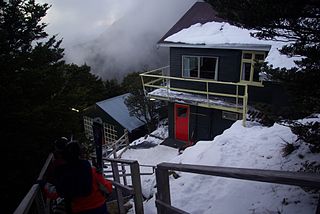
Pourangahau / Mount Robert is a 1,421m high mountain in the Nelson area of New Zealand's South Island. It is within the Nelson Lakes National Park. For many years Mt Robert formed part of landowner and politician John Kerr of Nelson's Lake Station, but was returned to the crown in the years following his death in 1898. The partially unsealed Mt Robert Road, just west of the town of Saint Arnaud leads to a car park that is the start of tramping tracks into the Nelson Lakes National Park, and also a 5-hour loop walk up the mountain: The Pinchgut Track zigzags steeply up to near the top of Mt Robert, then continues along a ridge to Bushline Hut, before descending via the more gentle Paddy's Track. The track offers view over Lake Rotoiti and St Arnaud.

Ben Lomond is a mountain close to Queenstown, New Zealand. It was named after Ben Lomond in Scotland by the early shepherd Duncan McAusland. The summit is approximately 4 km (2.5 mi) northwest of the town centre and reaches a height of 1,748 metres (5,735 ft). Connected to Ben Lomond are the large but slightly shorter Bowen Peak and Bob's Peaks, while nearby is the dominant feature of Queenstown Hill. There are scenic views available from a range of places on the mountain with the top giving a 360-degree panorama of much of the Wakatipu Basin including Lake Wakatipu, The Remarkables Mountains, Cecil Peak and Walter Peak.

Hutt Water Collection Area is a reserve located in Upper Hutt in the Wellington Region at the southern end of New Zealand's North Island. It is administered by Wellington Regional Council and is located alongside the larger Kaitoke Regional Park.

The Wangapeka Track is a tramping track in the north-west of the South Island of New Zealand. It is one of the main tramping tracks in the Kahurangi National Park, a protected area managed by the Department of Conservation. The route traverses the southern end of the park, from the historic Wangapeka goldfields area west of Tapawera, to the coastal plains of the West Coast at Little Wanganui. The route is 59 km (37 mi) long, and crosses the Wangapeka and Little Wanganui saddles, each over 1,000 m (3,300 ft) in elevation. The track passes through the valleys of the Wangapeka River, Karamea River, Taipō River and Little Wanganui River. The majority of the track is in river valleys and under forest cover, with small sections in tussock land at Stag Flat and the Little Wanganui Saddle. It typically takes walkers 4–6 days to complete the route.

Whakapapa Village is a small village in the Ruapehu District of New Zealand, which serves as the main entrance to Tongariro National Park.


