Springston

Last updated

Springston
Rural settlement
Springston.jpg
War memorial in Springston
Springston
Coordinates: 43°38′S172°25′E / 43.633°S 172.417°E / -43.633; 172.417
Country New Zealand
Region Canterbury
Territorial authority Selwyn District
WardSprings
Electorates
Government
  Territorial authority Selwyn District Council
  Regional council Environment Canterbury
   Mayor of Selwyn Sam Broughton
   Selwyn MP Nicola Grigg
   Te Tai Tonga MP Tākuta Ferris
Area
[1]
  Total0.37 km2 (0.14 sq mi)
Population
 (June 2023) [2]
  Total580
  Density1,600/km2 (4,100/sq mi)
Time zone UTC+12 (New Zealand Standard Time)
  Summer (DST) UTC+13 (New Zealand Daylight Time)

Springston is a small rural Canterbury town in the South Island of New Zealand

Contents

Springston was developed around the mid-19th century, beginning with the establishment of Spring Station by James E. FitzGerald, who farmed there from 1853 to 1857, and then again from 1860 to 1867. [3] The first building in the village was a Methodist church, which opened in 1866 (replaced by a second building in 1873). [4] Walter Lawry, who emigrated with his wife and 10 children to New Zealand in 1862, was Methodist preacher in Springston for 50 years. [5]

St Mary's Church, which opened in 1875, was one of the earliest Anglican churches in Canterbury. Clergyman Harry Stocker, newly arrived from Ireland, helped organise subscriptions and donations to fund the building of both it and St Paul's in Tai Tapu (1876). Both churches were designed by Christchurch architect Frederick Strouts, who later designed Ivey Hall at Lincoln University. [6]

The George Roy Store was formerly known as Howard and Dartnall, a store established in 1874 by Harry Lloyd Dartnall in partnership with his relative Mr. Howard. [7] Other historic buildings include the Springston Hotel, the original Methodist parsonage, and four cottages over 100 years old. [8]

The Springston rugby grounds at the Domain hold rugby cricket and tennis for locals and surrounding residents. The Springston Pony Club started the South Island's Springston Trophy in 1976. Springston has a pub, dairy, and community hall on Leeston Road.

Demographics

Springston is described by Statistics New Zealand as a rural settlement. It covers 0.37 km2 (0.14 sq mi). [1] It had an estimated population of 580 as of June 2023, [2] with a population density of 1,568 people per km2.

Historical population for the Springston settlement
YearPop.±% p.a.
2006351    
2013507+5.39%
2018534+1.04%
Source: [9]

The settlement had a population of 534 at the 2018 New Zealand census, an increase of 27 people (5.3%) since the 2013 census, and an increase of 183 people (52.1%) since the 2006 census. There were 177 households, comprising 264 males and 267 females, giving a sex ratio of 0.99 males per female, with 150 people (28.1%) aged under 15 years, 63 (11.8%) aged 15 to 29, 258 (48.3%) aged 30 to 64, and 63 (11.8%) aged 65 or older.

Ethnicities were 91.6% European/Pākehā, 9.0% Māori, 2.8% Pasifika, 3.9% Asian, and 2.8% other ethnicities. People may identify with more than one ethnicity.

Although some people chose not to answer the census's question about religious affiliation, 61.2% had no religion, 30.3% were Christian, 1.7% were Buddhist and 1.7% had other religions.

Of those at least 15 years old, 87 (22.7%) people had a bachelor's or higher degree, and 48 (12.5%) people had no formal qualifications. 93 people (24.2%) earned over $70,000 compared to 17.2% nationally. The employment status of those at least 15 was that 219 (57.0%) people were employed full-time, 57 (14.8%) were part-time, and 12 (3.1%) were unemployed. [9]

Springston statistical area

Springston statistical area surrounds and includes the settlement and covers 118.27 km2 (45.66 sq mi). [1] It had an estimated population of 2,380 as of June 2023, [10] with a population density of 20.1 people per km2.

Historical population for the statistical area
YearPop.±% p.a.
20061,653    
20132,031+2.99%
20182,157+1.21%
Source: [11]
John Edward FitzGerald photographed with his oldest son at Springs Station, Canterbury, by Dr Alfred Charles Barker, between 1858 and 1867 Barker Springs Station Springston with Mr J E Fitzgerald.jpg
John Edward FitzGerald photographed with his oldest son at Springs Station, Canterbury, by Dr Alfred Charles Barker, between 1858 and 1867
St Mary's Church, Springston St Marys Springston 6670.jpg
St Mary's Church, Springston

Before the 2023 census, Springston statistical area had a larger boundary, covering 119.12 km2 (45.99 sq mi). [1] Using that boundary, The statistical area had a population of 2,157 at the 2018 New Zealand census, an increase of 126 people (6.2%) since the 2013 census, and an increase of 504 people (30.5%) since the 2006 census. There were 729 households, comprising 1,068 males and 1,086 females, giving a sex ratio of 0.98 males per female. The median age was 40.8 years (compared with 37.4 years nationally), with 456 people (21.1%) aged under 15 years, 381 (17.7%) aged 15 to 29, 1,035 (48.0%) aged 30 to 64, and 285 (13.2%) aged 65 or older.

Ethnicities were 92.4% European/Pākehā, 6.5% Māori, 1.7% Pasifika, 3.8% Asian, and 2.4% other ethnicities. People may identify with more than one ethnicity.

The percentage of people born overseas was 14.6, compared with 27.1% nationally.

Although some people chose not to answer the census's question about religious affiliation, 55.6% had no religion, 35.0% were Christian, 0.4% were Hindu, 0.7% were Buddhist and 1.8% had other religions.

Of those at least 15 years old, 369 (21.7%) people had a bachelor's or higher degree, and 249 (14.6%) people had no formal qualifications. The median income was $38,100, compared with $31,800 nationally. 408 people (24.0%) earned over $70,000 compared to 17.2% nationally. The employment status of those at least 15 was that 933 (54.9%) people were employed full-time, 327 (19.2%) were part-time, and 39 (2.3%) were unemployed. [11]

Education

Springston School is a full primary school catering for years 1 to 8. [12] It had a roll of 215 as of February 2024. [13] The school was established in 1868. [14]

Related Research Articles

<span class="mw-page-title-main">Kingston, New Zealand</span> Rural settlement in Otago, New Zealand

Kingston is a small town at the southernmost end of Lake Wakatipu, just north of the border of Otago and Southland, in New Zealand's South Island. It is 47 kilometres south of Queenstown by a road, "The Devil's Staircase", which winds between the lake to the west and The Remarkables mountains to the east. It is 70 kilometres north of Lumsden, and close to the headwaters of the Mataura River.

<span class="mw-page-title-main">Riwaka</span> Town in Tasman, New Zealand

Riwaka is a small settlement in the Tasman District of New Zealand's South Island. It lies beside Tasman Bay / Te Tai-o-Aorere, five kilometres north of Motueka, and close to the mouth of the Riuwaka River. The land where the town is based was a swamp known as Tureauraki. Europeans first settled in Riwaka in May 1842. The Riwaka economy has been based around growing tobacco and hops.

<span class="mw-page-title-main">Cave, New Zealand</span> Town in Canterbury, New Zealand

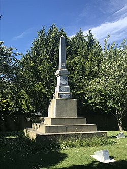
Cave is a town located in the Timaru District, South Island, New Zealand. It is approximately 23 kilometres (14 mi) north-west of Timaru on State Highway 8. St. David's Memorial Church was commissioned by Thomas Burnett and designed by Herbert W. Hall. Built in 1930, it is registered as a category I heritage building with Heritage New Zealand.

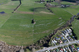
Pounawea is a small town in The Catlins, an area of the southern South Island of New Zealand. It is located four kilometres southwest of Owaka, at the mouth of the Catlins River. It is a popular holiday spot with a seasonal population, there are numerous cribs at the settlement.

Waipapa is a small town in the Bay of Islands, Northland, New Zealand. It is located on State Highway 10, approximately 10 minutes drive from Kerikeri, the nearest urban centre. Waipapa itself has no school with most pupils travelling to Kerikeri on a daily basis. It is governed by the Far North District council.

Ōkura is a northern suburb of the North Shore, part of the contiguous metropolitan area in Auckland, New Zealand. It is under the local governance of the Auckland Council. The official name is spelled with a macron.

<span class="mw-page-title-main">Spencerville, New Zealand</span> Suburb of Christchurch, New Zealand

Spencerville is a semi-rural town on the east coast of Canterbury, New Zealand north of Christchurch. The town backs on to Bottle Lake Forest and includes a large park and 80 hectare camping ground. These amenities, as well as wetlands and an animal and bird park make the town a popular camping area for Christchurch residents.

<span class="mw-page-title-main">Tata Beach</span> Settlement in Tasman District, New Zealand

Tata Beach is a beach and small coastal settlement of predominantly holiday houses in the South Island, New Zealand. Found in the Golden Bay region, it is approximately 14 kilometres (8.7 mi) north-east of Tākaka.

<span class="mw-page-title-main">Tokomaru, New Zealand</span> Settlement in Manawatū-Whanganui, New Zealand

Tokomaru is a small town in the district of Horowhenua, in the southwestern North Island of New Zealand. It is located 18 kilometres southwest of Palmerston North, and a similar distance northeast of Shannon. The Tokomaru railway station on the North Island Main Trunk was open from 1885 to 1982.

Wallacetown is a small town in Southland, in the South Island of New Zealand. Wallacetown is to the west of Invercargill, on high ground between the Makarewa and Ōreti rivers, near the Ōreti's estuary. Both rivers are popular for trout and whitebait fishing. It is considered to be a satellite town of Invercargill. It is served by State Highway 99, which skirts the town's northern edge.

<span class="mw-page-title-main">Luggate</span> Town in the South Island of New Zealand

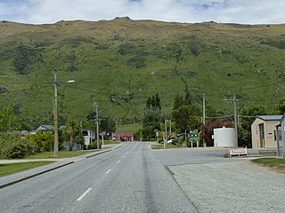
Luggate is a small town in the South Island of New Zealand. It is located on State Highway 6 between Wānaka and Cromwell, near the junction with State Highway 8A, approximately 15 km from the Wānaka township, just past Wānaka Airport.

<span class="mw-page-title-main">Prebbleton</span> Minor urban area in Canterbury, New Zealand

Prebbleton is a small town in the Selwyn District in the Canterbury Region of New Zealand. It is 11 km southwest of the centre of Christchurch and about 2 km south of the outlying industrial suburb of Hornby.

<span class="mw-page-title-main">The Pines Beach</span> Human settlement in Waimakariri District, Canterbury Region, New Zealand

The Pines Beach is a small town situated roughly 4 km east of Kaiapoi in the Canterbury region of the South Island of New Zealand. It is 1 km north of the mouth of the Waimakariri River. It takes its name from its close proximity to both a pine forest and the beach.

Stirling is a settlement in New Zealand. It is located in South Otago, approximately 5 km from Balclutha, and just north of the Matau Branch of the Clutha River.

<span class="mw-page-title-main">Ashley, New Zealand</span> Settlement in Canterbury, New Zealand

Ashley is a small town in North Canterbury, in the South Island of New Zealand. It used to have a railway station on the Main North Line that runs through the village.

<span class="mw-page-title-main">Pōhara</span> Settlement in Tasman District, New Zealand

Pōhara is a rural locality in the Tasman District of New Zealand's South Island. The locality is northeast of Tākaka and southwest of Tata Beach. To the north is Limestone Bay, part of Golden Bay / Mohua

<span class="mw-page-title-main">Waiau Pa</span> Place in Auckland Region, New Zealand

Waiau Pa is a small town of Auckland, New Zealand. It is in the Franklin Ward of Auckland Council. The name means "River of swirling currents" in the Māori language.

<span class="mw-page-title-main">Patumāhoe</span> Place in Auckland Region, New Zealand

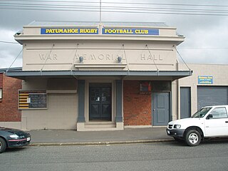
Patumāhoe is a small town of Auckland, New Zealand. It is in the Franklin Ward of Auckland Council.

<span class="mw-page-title-main">Woodbourne, New Zealand</span> Settlement in Marlborough, New Zealand

Woodbourne is a rural settlement in Marlborough, New Zealand. It is located on State Highway 6, 8 kilometres (5 mi) west of Blenheim, and 4 km (2 mi) east of Renwick. Woodbourne Airport is the major airport for Marlborough, and RNZAF Base Woodbourne shares the airport's runways.

Rangitane or Rangitāne is a settlement on the east bank of the Rangitane River and the northern shore of the Kerikeri Inlet in the Far North District of New Zealand. It is 13 km north-west of Kerikeri by road.

References

  1. 1 2 3 4 "ArcGIS Web Application". statsnz.maps.arcgis.com. Retrieved 29 March 2024.
  2. 1 2 "Subnational population estimates (RC, SA2), by age and sex, at 30 June 1996-2023 (2023 boundaries)". Statistics New Zealand . Retrieved 25 October 2023. (regional councils); "Subnational population estimates (TA, SA2), by age and sex, at 30 June 1996-2023 (2023 boundaries)". Statistics New Zealand . Retrieved 25 October 2023. (territorial authorities); "Subnational population estimates (urban rural), by age and sex, at 30 June 1996-2023 (2023 boundaries)". Statistics New Zealand . Retrieved 25 October 2023. (urban areas)
  3. McIntyre, W. David (1990). "FitzGerald, James Edward". Dictionary of New Zealand Biography. Retrieved 4 December 2019.
  4. "Springston Medthodist Church jubilee celebrations". Ellesmere Guardian. 2 August 1916. Retrieved 4 December 2019.
  5. Chambers, W. A. (1993). "Lawry, Samuel". Dictionary of New Zealand Biography. Retrieved 4 December 2019.
  6. Holmes, John (1977). Saint Stephens Church, Lincoln, Historical Notes. Lincoln: St. Stephen's Church.
  7. Dartnall, Cyril (2002). "Springston Store – Howard and Dartnall". Selwyn Kete. Retrieved 4 December 2019.
  8. "Springston". Selwyn District Council. Retrieved 4 December 2019.
  9. 1 2 "Statistical area 1 dataset for 2018 Census". Statistics New Zealand. March 2020. 7026932, 7026933 and 7026934.
  10. "Population estimate tables - NZ.Stat". Statistics New Zealand . Retrieved 25 October 2023.
  11. 1 2 "Statistical area 1 dataset for 2018 Census". Statistics New Zealand. March 2020. Springston (335000). 2018 Census place summary: Springston
  12. Education Counts: Springston School
  13. "New Zealand Schools Directory". New Zealand Ministry of Education. Retrieved 14 March 2024.
  14. "History of the School". Springston School. 18 March 2020.

Commons-logo.svg Media related to Springston at Wikimedia Commons