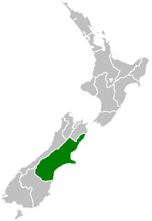
The Canterbury Plains is an area in New Zealand centred in the Mid Canterbury, to the south of the city of Christchurch in the Canterbury region. Their northern extremes are at the foot of the Hundalee Hills in the Hurunui District, and in the south they merge into the plains of North Otago beyond the Waitaki River.

The Kaiapoi River is a minor river of north Canterbury, in New Zealand's South Island. Originally called the Cam River, it is a tributary of the Waimakariri River, which it joins at the larger river's estuary. The river is 16 kilometres (10 mi) long, and its drainage area is about 430 square kilometres (170 sq mi).
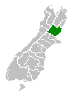
Hurunui District is a political district on the east coast of New Zealand's South Island, north of Christchurch, New Zealand. It forms part of the Canterbury region and stretches from the east coast to the main divide. Its land area is 8,660.43 square kilometres (3,343.81 sq mi).

Avondale is a suburb of Christchurch in the South Island of New Zealand. It is located 6 kilometres (3.7 mi) northeast of the city center, and is close to the Avon River, four kilometers to the northwest of its estuary. The suburb is centered on Avondale Road and so named due to its proximity to the Avon River. It has a good sized park on Mervyn Drive called Avondale Park. This park has a kids playground, a tennis court, basketball court, and a football field in winter. There is ample vacant red zone land in Avondale for activities such as leisure and dog walking.
The Cust River is a river in the Canterbury Region of New Zealand. It flows east across the upper Canterbury Plains from its source north of the town of Oxford, New Zealand, flowing into the Cam River / Ruataniwha close to the town of Rangiora. The small town of Cust lies on the banks of the river. The lower part of the river, to the south-west of Rangiora, is diverted into a channel and called the "Main Drain". The channel was built in 1862 to drain the swampy land between Rangiora and the Waimakariri River, and when it was enlarged in 1868 it accidentally captured the Cust.
The Garry River is a river in the Canterbury Region of New Zealand. It arises in the Mount Thomas Forest near Mount Thomas and flows south-east into Ashley River/Rakahuri. Blowhard Stream is a tributary.

The Glentui River is a river in the Canterbury region of New Zealand. It arises on the slopes of Mount Richardson and flows south-east through the locality of Glentui and into Ashley River/Rakahuri, which exits in the Pacific Ocean. The river was earlier called Tui Creek, and the locality named from the station Glentui established by H.C.H. Knowles in 1854.
The Hawkins River is a river of New Zealand. A major tributary of Canterbury's Selwyn River, it flows generally southeast from its source to the southwest of Springfield, reaching the Selwyn 10 kilometres (6 mi) west of Burnham.
The Hororata River is a river of Canterbury, in the South Island of New Zealand. A tributary of the Selwyn River, the Hororata has its sources in rough hill country north of Windwhistle, and flows east through the township of Hororata before reaching the Selwyn 12 kilometres (7 mi) northwest of Dunsandel.
The Irwell River, New Zealand is a river of the Canterbury Plains, in New Zealand's South Island. A short river, it rises to the southeast of Dunsandel, flowing southeast to enter the broad, shallow Lake Ellesmere.
The Karetu River is a river of New Zealand's eastern South Island. It flows south from the slopes of Mount Karetu before its outflow into the Okuku River at the edge of the Canterbury Plains 40 kilometres (25 mi) northwest of Christchurch.
The Lilburne River is a river of northern Canterbury, New Zealand. Formerly known as the Lillburn River, its spelling was corrected in 2003. It rises in the Puketeraki Range, flowing south then east to join Ashley River/Rakahuri.
The Makerikeri River is a river of the north Canterbury Region of New Zealand's South Island. It flows south from its headwaters 15 kilometres (9 mi) west of Amberley, reaching the Ashley River close to Rangiora.
The Okuku River is a river of the north Canterbury Region of New Zealand's South Island. It flows predominantly south from several sources in and close to the eastern edge of the Puketeraki Range west of Waikari, flowing through a steep gorge in the Okuku Range before flowing into the Ashley River 20 kilometres (12 mi) east of Oxford.
The Okuti River is a river of Banks Peninsula, in the Canterbury Region of New Zealand's South Island. It flows west to meet the Okana River. The combined waters form the Takiritawai River, a short stream which flows into the eastern end of Lake Forsyth 2 kilometres (1.2 mi) south of the settlement of Little River.
The Old Bed Eyre River is a river of the Canterbury Region of New Zealand's South Island. It lies to the south of the Eyre River, into which it flows near Kaiapoi.
The Takiritawai River is a river of the Canterbury Region of New Zealand's South Island. A short river of approximately 1.5 kilometres (0.93 mi), it flows from the confluence of the Okana and Okuti Rivers to feed the top of Lake Forsyth, at the southwest of Banks Peninsula.
The Townshend River is a river of the Canterbury Region of New Zealand's South Island. It rises in the Puketeraki Range 20 kilometres (12 mi) north of Springfield and flows generally east to reach the Ashley River 10 kilometres (6 mi) north of Oxford, upstream from the Ashley Gorge.
The Whistler River is a river of the Canterbury Region of New Zealand's South Island. It flows generally southeast from the Puketeraki Range to reach the Ashley River 15 kilometres (9 mi) north of Oxford.
The Eyre River is a river in the Canterbury region of New Zealand. It arises in the Puketeraki Range and flows south-east into the Waimakariri River near Christchurch International Airport. The connection with the Waimakariri is via a diversion channel running south-west, replacing the Eyre's original easterly flow. The river is named after Edward John Eyre, the Lieutenant-Governor of New Munster from 1848–53.