Selwyn River / Waikirikiri

Last updated

Selwyn River / Waikirikiri
Selwyn River NZ.jpg
Selwyn River near Dunsandel, November 2017
New Zealand relief map.jpg
Disc Plain red.svg
Location of the mouth within New Zealand
EtymologyTranslates as "gravelly water", and named after Bishop Selwyn.
Native nameWaikirikiri (Māori)
Location
CountryNew Zealand
Physical characteristics
Source 
  location Southern Alps
Mouth  
  location
Lake Ellesmere / Te Waihora
Length80 km (50 mi)

The Selwyn River / Waikirikiri flows through the Selwyn District of Canterbury in the South Island of New Zealand. [1]

Contents

Description

Result of flooding on the Selwyn River - Glentunnel, NZ. June 2021 Selwyn River Flood May 2021 (1).jpg
Result of flooding on the Selwyn River - Glentunnel, NZ. June 2021

The river has its source in the Southern Alps and flows east for 80 kilometres (50 mi) before emptying into Lake Ellesmere / Te Waihora, south of Banks Peninsula. Terrace cliffs above the river's upper reaches gave the town of Whitecliffs its name.

For much of its course the river flows through wide shingle channels. In drought years, the river can disappear beneath this bed and seem to dry up completely. This frequently occurs where State Highway 1 crosses the river at the settlement of Selwyn, about 20 kilometres (12 mi) upstream from its outflow into Lake Ellesmere.

In the foothills, the Selwyn flows year-round. On the plains, the riverbed is highly permeable, and the river overlays a deep and porous aquifer. As soon as the river reaches the plains, water begins leaking down through the bed and into the aquifer. In most months, all river-water disappears within 5 kilometres (3 mi) of leaving the foothills. The next 35 kilometres (22 mi) of the river remains dry for most of the year, apart from a small section around the confluence with the permanently flowing Hororata River. About 15 kilometres (9 mi) upstream from Lake Ellesmere shallow groundwater rises back to the surface, and the Selwyn becomes permanent again.

Bridges

There are six bridges that cross the Selwyn River. These are at: Whitecliffs (Whitecliffs Road), Glentunnel (SH 77), Coalgate (Hororata Road), Hororata (Bealey Road), Selwyn (SH 1) and Irwell (Leeston Road). It is also possible to cross at Coes Ford when the river is not in flood. Chamberlains Ford is no longer a ford. The nearby Irwell bridge provides access to the other side of the river. [2]

Ecology

Disappearing river flows have significant ecological effects: when the river’s surface water disappears, so does the habitat for many aquatic plants and animals. In response to loss of surface water, aquatic invertebrates and fish must disperse, seek refuge in remnant aquatic habitats, or die. Aquatic plants, algae, and bacteria must form resting stages or die. The dry central reaches of the Selwyn River also constitute a significant barrier for dispersal of invertebrates and for fish migrating between Lake Ellesmere and the headwaters. [3]

Fishing

The Selwyn river was viewed historically as one of New Zealand’s best trout fisheries. In the 1960s a trout trap at Coes Ford was reported to count up to 14,000 returning spawning trout. In 2017, the numbers have declined to the stage that only dozens of trout could be counted when returning to spawn. [4] The fish in the river have been described as low in number and the majority of the fish are quite small. [5]

Pollution

The Canterbury Regional Council (ECan) has permitted intensive dairy farming around Selwyn and it has been suggested that this has led to a deterioration in the water quality of the Selwyn river. [6] In May 2021, it was reported that Nitrate levels in the Selwyn River has increased by 50%.

It is no longer recommended that people go swimming in the Selwyn River. Coes Ford was once a well known swimming spot in Canterbury. [7] [8] The water at Coes Ford was reported to be in the worst 25% in New Zealand for total nitrate levels in 2020. [9] The pollution at Coes Ford is thought to come from Silverstream creek, which used surrounded by many of the dairy farms in the area. [10]

Chamberlain's Ford which crosses the Selwyn RIver had an algal bloom health warning issued in December 2020. There were benthic cyanobacteria found in the river. [11] Algal Blooms of benthic cyanobacteria have also been reported at in the Selwyn river at Whitecliffs Domain and Whitecliffs Road in March 2021. [12]

Greenpeace placed billboards in the Selwyn River to protest the degree of pollution in it in February 2020. [13]

Naming

The Selwyn River and its gorge were named in 1849 by the chief surveyor of the Canterbury Association, Joseph Thomas, for Bishop Selwyn. The name was later adopted for the township, the district, and an electorate. [14]

The New Zealand Ministry for Culture and Heritage gives a translation of "gravelly stream" for Waikirikiri. [15]

Related Research Articles

<span class="mw-page-title-main">Lake Ellesmere / Te Waihora</span> Lagoon in New Zealand

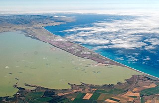
Lake Ellesmere / Te Waihora is a broad, shallow coastal lake or waituna, in the Canterbury region of the South Island of New Zealand. It is directly to the west of Banks Peninsula, separated from the Pacific Ocean by the long, narrow, sandy Kaitorete Spit, or more correctly Kaitorete Barrier. It lies partially in extreme southeastern Selwyn District and partially in the southwestern extension of the former Banks Peninsula District, which now is a ward in the city of Christchurch. The lake holds high historical and cultural significance to the indigenous Māori population and the traditional Māori name Te Waihora, means spreading waters. It has officially had a dual English/Māori name since at least 1938.

<span class="mw-page-title-main">Lake Tekapo</span> Lake in the South Island of New Zealand

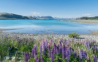
Lake Tekapo is the second-largest of three roughly parallel lakes running north–south along the northern edge of the Mackenzie Basin in the South Island of New Zealand. It covers an area of 83 square kilometres (32 sq mi), and is at an altitude of 710 metres (2,330 ft) above sea level.

<span class="mw-page-title-main">Leeston</span> Town in South Island, New Zealand

Leeston is a town on the Canterbury Plains in the South Island of New Zealand. It is located 30 kilometres southwest of Christchurch, between the shore of Lake Ellesmere / Te Waihora and the mouth of the Rakaia River. The town is home to a growing number of services which have increased and diversified along with the population. Leeston has a supermarket, schools, churches, hospital, gym, cafes, restaurants, medical centre, pharmacy and post office. The Selwyn District Council currently has a service office in Leeston, after the headquarters was shifted to Rolleston.

<span class="mw-page-title-main">Rangitata River</span> River in New Zealand

The Rangitata River is one of the braided rivers that helped form the Canterbury Plains in southern New Zealand. It flows southeast for 120 kilometres (75 mi) from the Southern Alps, entering the Pacific Ocean 30 kilometres (19 mi) northeast of Timaru. The river has a catchment area of 1,773 square kilometres (685 sq mi), and a mean annual flow of 95 cubic metres per second (3,400 cu ft/s) at Klondyke.

<span class="mw-page-title-main">Lake Alexandrina (New Zealand)</span> Lake in the South Island of New Zealand

Lake Alexandrina is a lake located in the Mackenzie Basin of New Zealand's South Island. It lies immediately to the west of the much larger Lake Tekapo and further to the east of Lake Pukaki, located to the north of Lake Tekapo township. It is a shallow lake with distinct indications of glacial origin and is spring fed with an outlet on its eastern shore midway down the lake. The outlet feeds into a smaller lake, Lake MacGregor before feeding into Lake Tekapo described as “Opaque and milky blue” in colour. In the desert terrain of the Mackenzie Plains, Lake Alexandrina is considered as an “oasis of life”. Lake Alexandrina is a Wildlife Refuge and a delight to a fisherman, well documented for its brown and rainbow trout and salmon.

<span class="mw-page-title-main">Lake Coleridge</span> Lake in the South Island of New Zealand

Lake Coleridge is located in inland Canterbury, in New Zealand's South Island. Located 35 kilometres (22 mi) to the northwest of Methven, it has a surface area of 47 square kilometres (18 sq mi). The lake is situated in an over-deepened valley formed by a glacier over 20,000 years ago in the Pleistocene era. It currently has no natural outflows. There is a small settlement at the lake.

<span class="mw-page-title-main">Selwyn District</span> Territorial authority district in Canterbury, New Zealand

Selwyn District is a predominantly rural district in central Canterbury, on the east coast of New Zealand's South Island. It is named after the Selwyn River / Waikirikiri, which is in turn named after Bishop George Selwyn, the first Anglican bishop of New Zealand who, in 1843 and 1844, travelled the length of the country by horse, foot, boat and canoe, leaving in his wake a sprinkling of locations that now bear his name.

<span class="mw-page-title-main">Springfield, New Zealand</span> Village in Canterbury, New Zealand

Springfield is a small town in the Selwyn District of Canterbury, in the South Island, of New Zealand. The Maori name for Springfield is Tawera.

A losing stream, disappearing stream, influent stream or sinking river is a stream or river that loses water as it flows downstream. The water infiltrates into the ground recharging the local groundwater, because the water table is below the bottom of the stream channel. This is the opposite of a more common gaining stream which increases in water volume farther downstream as it gains water from the local aquifer.

Whitecliffs is a village located in the Selwyn District of the Canterbury region of New Zealand's South Island. It has also been known as South Malvern, and the name of Whitecliffs comes from terrace cliffs above the Selwyn River / Waikirikiri.

<span class="mw-page-title-main">Glentunnel</span> Village in Canterbury, New Zealand

Glentunnel is a village located in the Selwyn District of the Canterbury region of New Zealand's South Island.

<span class="mw-page-title-main">Dunsandel</span> Town in Canterbury, New Zealand

Dunsandel is a small rural town in the Canterbury region of the South Island, New Zealand. The town is located on the Canterbury Plains just south of the Selwyn River / Waikirikiri and about 40 km south of Christchurch. Dunsandel is a junction town on SH1, halfway between Christchurch and Ashburton, with roads leading to Leeston, Southbridge and Hororata. The town provides an important refreshment stop for main road travellers with eateries and coffee shops, as well as acting as a support town for the rural hinterland.

The Hawkins River is a river of New Zealand. A major tributary of Canterbury's Selwyn River / Waikirikiri, it flows generally southeast from its source to the southwest of Springfield, reaching the Selwyn 10 kilometres (6 mi) west of Burnham.

The Hororata River is a river of Canterbury, in the South Island of New Zealand. A tributary of the Selwyn River, the Hororata has its sources in rough hill country north of Windwhistle, and flows east through the township of Hororata before reaching the Selwyn 12 kilometres (7 mi) northwest of Dunsandel.

<span class="mw-page-title-main">L II River</span> River in New Zealand

The L II River is a small spring-fed river in Canterbury, New Zealand. It rises near Lincoln and flows through very flat farmland, mostly fed by land drainage ditches before emptying into Lake Ellesmere / Te Waihora just east of the mouth of the Selwyn River / Waikirikiri.

<span class="mw-page-title-main">Hororata</span> Village in Canterbury, New Zealand

Hororata is a village at the northwestern edge of the Canterbury Plains in the South Island of New Zealand. It is located 15 kilometres southwest of Darfield, five kilometres south of Glentunnel, and 50 kilometres west of Christchurch, on the banks of the Hororata River. Hororata, when translated from Maori means "drooping rata". There are a large number of rata growing in the district.

<span class="mw-page-title-main">Kelvin Coe (mayor)</span>

Kelvin John Coe was the Mayor of Selwyn District in New Zealand from 2007 to 2016.

<span class="mw-page-title-main">Hororata Highland Games</span> Scottish game event festival hosted in New Zealand

The Hororata Highland Games is an annual event held in Hororata, New Zealand. The Games began in 2011, following the 2010 Canterbury earthquake. The Hororata community had a desire to make a positive change following the damage of the Canterbury earthquakes. The annual event has increased in popularity with 10,000 people coming to the 2016 edition. It has since become New Zealand's biggest Scottish festival.

<span class="mw-page-title-main">Susie Wood</span> New Zealand microbiologist and marine scientist

Susanna Wood is a New Zealand scientist whose research focuses on understanding, protecting and restoring New Zealand's freshwater environments. One of her particular areas of expertise is the ecology, toxin production, and impacts of toxic freshwater cyanobacteria in lakes and rivers. Wood is active in advocating for the incorporation of DNA-based tools such as metabarcoding, genomics and metagenomics for characterising and understanding aquatic ecosystems and investigating the climate and anthropogenic drivers of water quality change in New Zealand lakes. She has consulted for government departments and regional authorities and co-leads a nationwide programme Lakes380 that aims to obtain an overview of the health of New Zealand's lakes using paleoenvironmental reconstructions. Wood is a senior scientist at the Cawthron Institute. She has represented New Zealand in cycling.

<span class="mw-page-title-main">Waituna</span> Type of freshwater coastal lagoon in New Zealand

A waituna is a freshwater coastal lagoon on a mixed sand and gravel (MSG) beach, formed where a braided river meets a coastline affected by longshore drift. This type of waterbody is neither a true lake, lagoon nor estuary.

References

  1. "Place name detail: Selwyn River/Waikirikiri". New Zealand Gazetteer. New Zealand Geographic Board . Retrieved 5 April 2008.
  2. "Selwyn District Council". Selwyn District Council. Retrieved 16 May 2021.
  3. Mike Scarsbrook; Scott Larned; Graham Fenwick; Dave Kelly. "Biodiversity in a disappearing river". NIWA. Archived from the original on 23 February 2013. Retrieved 22 March 2013.
  4. "Welcome To The Future – Popular Family Swimming Spot Dries Up | Fish & Game NZ". Fish & Game. Retrieved 16 May 2021.
  5. "Selwyn River". nzfishing.com. Retrieved 16 May 2021.
  6. "Nitrates in Selwyn River up 50% in 22 months, Federation of Freshwater Anglers says". NZ Herald. Retrieved 16 May 2021.
  7. "Where we used to swim: The turning point for Canterbury's Selwyn River". Stuff. 5 January 2020. Retrieved 16 May 2021.
  8. "Selwyn". Swimmable Rivers. Retrieved 16 May 2021.
  9. "Water quality data reveals a 'very mixed bag' for Canterbury rivers". Stuff. 28 September 2020. Retrieved 16 May 2021.
  10. "Where we used to swim: The turning point for Canterbury's Selwyn River". Stuff. 5 January 2020. Retrieved 12 November 2021.
  11. "Health Warning Removed For Algal Bloom In The Waikirikiri/ Selwyn River At Chamberlains Ford". www.scoop.co.nz. 2 February 2021. Retrieved 16 May 2021.
  12. "Health Warning Removed For Algal Bloom In The Selwyn/Waikirikiri River At Whitecliffs Domain And Whitecliffs Road". www.scoop.co.nz. 5 March 2021. Retrieved 16 May 2021.
  13. "Three billboards protest pollution in Canterbury's Selwyn River". Stuff. 13 February 2020. Retrieved 16 May 2021.
  14. Reed, A. W. (2010). Peter Dowling (ed.). Place Names of New Zealand. Rosedale, North Shore: Raupo. p. 362. ISBN   9780143204107.
  15. "1000 Māori place names". New Zealand Ministry for Culture and Heritage. 6 August 2019.

Coordinates: 43°45′S172°26′E / 43.750°S 172.433°E / -43.750; 172.433