


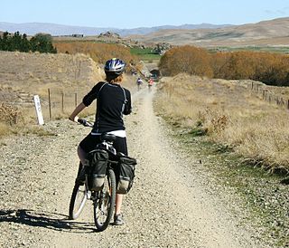
The Little River Rail Trail is a cycling and walking track on Banks Peninsula in the Canterbury region of New Zealand's South Island.
The Little River Rail Trail is a cycling and walking track on Banks Peninsula in the Canterbury region of New Zealand's South Island.
The rail trail utilises the formation of the Little River Branch railway, which ran from a junction with the Southbridge Branch from Hornby via Lincoln to Little River. The railway closed on 30 June 1962 and the formation had remained largely undisturbed until the early 2000s, when a trust was formed to revitalise it for public use.
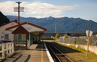
On 28 May 2006 the first section of the rail trail was opened, between Motukarara and Catons Bay Reserve. It has since been extended, first to the Little River hotel, and then to Wairewa Pa Road, [1] some 500 m short of the restored Little River station, which has preserved ex-New Zealand Railways freight wagons and a craft centre.
The second section between Prebbleton and Lincoln (7 km) opened on 30 November 2006. This section is an offroad track adjacent to the old railway line that runs alongside Birchs Road.
The third section between Hornby and Prebbleton (3.6 km) opened on 20 September 2009. [2] This section is an offroad track adjacent to Shands Road and Marshs Road. Between Marshs Road and Springs Road, the track is located within the old railway corridor. This extension thus incorporates part of the also closed Southbridge Branch's formation, as that was the line that linked the Little River Branch to the Main South Line in Hornby.
The Little River Rail Trail was awarded a Cycle Friendly Award in 2006 for the best cycle facility project in New Zealand by Cycling Advocates' Network.

The Ferrymead Railway is a New Zealand heritage railway built upon the track formation of New Zealand's first public railway, from Ferrymead to Christchurch, which opened on 1 December 1863. On the opening of the line to Lyttelton on 9 December 1867, the Ferrymead Railway became the Ferrymead Branch and was closed shortly thereafter. In 1964, rail enthusiasts began relaying track on the historic formation and the new 3 ft 6 in narrow gauge. Ferrymead Railway officially reopened in 1977. It now operates steam, diesel and electric trains regularly and is recognised as one of the most significant rail preservation sites in New Zealand.
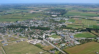
Lincoln is a town in the Selwyn District, in the Canterbury Region of New Zealand's South Island. The town is located on the Canterbury Plains to the west of Banks Peninsula, 22 kilometres southwest of Christchurch. The town has a population of 10,250, making it the second largest town in the Selwyn District behind nearby Rolleston.
The Otago Central Rail Trail is a 150-kilometre walking, cycling and horse riding track in the South Island of New Zealand. A pioneering project for New Zealand, the successful rail trail joined the New Zealand Cycle Trail umbrella organisation in 2012, having been one of the inspirations for it.
{{Infobox settlement
| name = Birdlings Flat
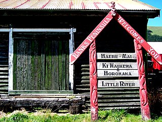
Little River is a town on Banks Peninsula in the Canterbury region of New Zealand.
The Ngapara and Tokarahi Branches were two connected railway branch lines in northern Otago, New Zealand, part of the national rail network. The Ngapara Branch opened in 1877 and almost all of it closed in 1959; the remaining few kilometres, called the Waiareka Industrial Line, were removed in 1997. The Tokarahi Branch branched off the Ngapara Branch. It operated from 1887 until 1930 and was originally known as the Livingstone Branch, though it never progressed beyond Tokarahi to Livingstone. In early 2008 there is a proposal to reinstate the first 4.5 km of the Ngapara Branch.
The Mount Somers Branch, sometimes known as the Springburn Branch, was a branch line railway in the region of Canterbury, New Zealand. The line was built in stages from 1878, reaching Mount Somers in 1885. A further section to Springburn was added in 1889; this closed in 1957, followed by the rest of the line in 1968. A portion has been preserved as the Plains Vintage Railway.

The Okaihau Branch, sometimes known as the Kaikohe Branch and rarely the Rangiahua Branch, was a branch line railway that joined the North Auckland Line of the national rail network of New Zealand at Otiria. It was the most northerly line in New Zealand and was intended to run all the way to Kaitaia. It opened to Ōkaihau in 1923 and closed in 1987.
The Southbridge Branch was a branch line railway that formed part of New Zealand's national rail network. It was located in the Canterbury region of the South Island and operated from 1875 until 1967. Five kilometres of the line remains open as the Hornby Branch, formerly the Hornby Industrial Line.

The Little River Branch was a branch line railway that formed part of New Zealand's national rail network. It diverged from the Southbridge Branch in Lincoln and ran down Banks Peninsula in the Canterbury region of the South Island. It was opened to Little River in 1886 and operated until 1962.
The Ross Branch, officially known as the Hokitika Line since 2011, and previously as the Hokitika Industrial Line, is a branch line railway that forms part of New Zealand's national rail network. It is located in the Westland District of the South Island's West Coast region and opened to Hokitika in 1893. A further extension to Ross operated from 1909 until 1980.

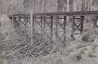
The East Gippsland Rail Trail is a rail trail located in East Gippsland in Victoria, Australia. The trail is a popular cycling route, beginning in Bairnsdale and extending to Orbost, following the route of the former Gippsland railway line. The Gippsland railway line was opened in 1916 to serve the agricultural and timber industry, and required numerous substantial bridges because of the nature of the terrain. Due to the decline in traffic and heavy operating costs, the line was finally closed in August 1987 and the track infrastructure removed in 1994. The shared trail is also available for walkers and recreational horseriding, however motorised vehicles are prohibited.
Rail transport in Christchurch, the largest city on New Zealand's South Island, consists of two main trunk railway lines intersecting in the suburb of Addington, carrying mainly long-haul freight traffic but also two long distance tourist-oriented passenger trains. The two lines are the Main North Line and Main South Line, collectively but unofficially known as the South Island Main Trunk Railway. There is a heritage line at the Ferrymead Historic Park that is operated with steam, electric, and diesel motive power hauling tourist-oriented services.

The Bellarine Rail Trail is a 32 km walking and cycling track on the Bellarine Peninsula, in Victoria, Australia, that follows the route of the former South Geelong to Queenscliff branch line. It runs from South Geelong to Queenscliff, passing through the towns of Leopold, Curlewis and Drysdale. The rails have been removed from the western section between South Geelong and Drysdale.
The Mansfield railway line is a closed 121-kilometre (75 mi) branch railway line situated in the Hume region of Victoria, Australia. Constructed by the Victorian Railways, it branched from the Seymour line at Tallarook station, and ran east to Mansfield. The line was primarily built to provide a general goods and passenger service to settlements in the area.
The Mirboo North railway line was a country branch line in Victoria, Australia. It branched from the main Gippsland line at Morwell station, and opened in three stages from 1885 to 1886. The stations along the line were Hazelwood, Yinnar, Boolarra, Darlimurla and Mirboo North.

The Thames Branch railway line connected Thames, New Zealand, with Hamilton and was originally part of the East Coast Main Trunk railway. Part of the line between Morrinsville and Waitoa remains open and is in use as the Waitoa Branch line, connecting to the Fonterra Dairy Factory at Waitoa.
The Forrest railway line is a former branch railway in Victoria, Australia. It branched off the Warrnambool railway line at Birregurra, and ran through the foothills of the Otway Ranges to the town of Forrest.