
Leeston is a town on the Canterbury Plains in the South Island of New Zealand. It is located 30 kilometres southwest of Christchurch, between the shore of Lake Ellesmere / Te Waihora and the mouth of the Rakaia River. The town is home to a growing number of services which have increased and diversified along with the population. Leeston has a supermarket, schools, churches, hospital, gym, cafes, restaurants, medical centre, pharmacy and post office. The Selwyn District Council currently has a service office in Leeston, after the headquarters was shifted to Rolleston.

Selwyn District is a predominantly rural district in central Canterbury, on the east coast of New Zealand's South Island. It is named after the Selwyn River / Waikirikiri, which is in turn named after Bishop George Selwyn, the first Anglican bishop of New Zealand who, in 1843 and 1844, travelled the length of the country by horse, foot, boat and canoe, leaving in his wake a sprinkling of locations that now bear his name.

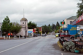
Springfield, called Kowai Pass until 1880, is a small town in the Selwyn District of Canterbury, in the South Island, of New Zealand. Springfield is situated in the foothills of the Southern Alps as the most westerly town of the Canterbury Plains. Springfield is 65 kilometres (40 mi) west of Christchurch on State Highway 73, 9.7 kilometres (6.0 mi) northwest of Sheffield and 22.7 kilometres (14.1 mi) from Darfield. It is located close to Porters Ski Area, Mount Cheeseman, Broken River, Temple Basin and Craigieburn ski fields. Springfield has a long association with the Midland railway line.

Southbridge is a small town on the Canterbury Plains in the South Island of New Zealand. It is located 45 kilometres (28 mi) southwest of Christchurch, between Leeston, Dunsandel and the Rakaia River.

West Melton is a town in the Selwyn District, in the Canterbury region of New Zealand's South Island. It is located 24 kilometres (15 mi) west of Christchurch and is part of the Christchurch metropolitan area. The town has a population of 2,450, making it the 123rd-largest urban area in New Zealand, the 16th-largest in Canterbury and fifth-largest in the Selwyn District.
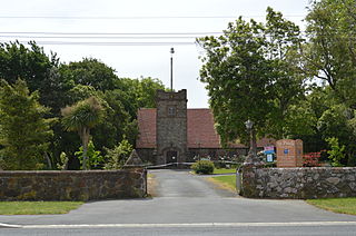
Doyleston is a minor Canterbury town in the South Island of New Zealand. It was named after Joseph Hastings Doyle, a publican from Christchurch who moved to the locality. Doyleston promised to be one of the main townships in the Ellesmere area, but before long Leeston overtook it and some businesses moved there. Doyleston had a school for many years, but it consolidated with Leeston School in the late 1930s.

Springston is a small rural Canterbury town in the South Island of New Zealand

Sheffield is a small village located in the Selwyn District of the Canterbury region of New Zealand's South Island, near the Waimakariri Gorge.

Glentunnel is a village located in the Selwyn District of the Canterbury region of New Zealand's South Island.

Waddington is a small village located in the Selwyn District of the Canterbury region of New Zealand's South Island, near the Waimakariri Gorge.
Waipapa is a small town in the Bay of Islands, Northland, New Zealand. It is located on State Highway 10, approximately 10 minutes drive from Kerikeri, the nearest urban centre. Waipapa itself has no school with most pupils travelling to Kerikeri on a daily basis. It is governed by the Far North District council.

Dunsandel is a small rural town in the Canterbury region of the South Island, New Zealand. The town is located on the Canterbury Plains just south of the Selwyn River / Waikirikiri and about 40 km south of Christchurch. Dunsandel is a junction town on SH1, halfway between Christchurch and Ashburton, with roads leading to Leeston, Southbridge and Hororata. The town provides an important refreshment stop for main road travellers with eateries and coffee shops, as well as acting as a support town for the rural hinterland.
Pukepoto is a town in Northland, New Zealand. It lies south west of Kaitaia and north east of Ahipara. The Herekino Forest lies to the south east.

Hororata is a village at the northwestern edge of the Canterbury Plains in the South Island of New Zealand. It is located 15 kilometres southwest of Darfield, five kilometres south of Glentunnel, and 50 kilometres west of Christchurch, on the banks of the Hororata River. Hororata, when translated from Maori means "drooping rata". There are a large number of rata growing in the district.
Tai Tapu, previously known as Taitapu, is a small town adjacent to the Halswell River and nestled in the Port Hills, located 6 km east of the town of Lincoln and 18 km south west of Christchurch in the Canterbury region of New Zealand's South Island. State Highway 75 passes through the centre of the village, connecting Christchurch with Akaroa and the Banks Peninsula.
Wakefield is a settlement in the Tasman District of New Zealand's South Island, located about 25km south west of Nelson.

Selwyn Heights is a suburb of Rotorua in the Bay of Plenty Region of New Zealand's North Island.
Waikaka is a town in Southland, New Zealand. It was a gold-mining town in the 19th century, starting in 1867 when gold was found. Over NZ£1,000,000 equivalent of gold was eventually extracted from this location. The town was served by the Waikaka branch railway.
Selwyn Huts, also called Upper Selwyn Huts, is a rural settlement close to the northern shore of Lake Ellesmere / Te Waihora in the Selwyn District of New Zealand. Lower Selwyn Huts is a smaller settlement 2.8 km further south.

Motukarara is a locality to the northeast of Lake Ellesmere / Te Waihora in the Selwyn District of New Zealand. State Highway 75 passes through the centre of the village, connecting Christchurch with Akaroa and the Banks Peninsula. The Little River Branch, which operated between 1886 and 1962, ran through Motukarara, and is now a shared walkway and cycleway.
