
Lake in the Hills is a village in McHenry County, Illinois, United States. As of the 2020 census, the population was 28,982.

Te Anau is a town in the Southland region of the South Island of New Zealand. In Māori, Te-Anau means the Place of the Swirling Waters. It is on the eastern shore of Lake Te Anau in Fiordland. Te Anau is 155 kilometres north of Invercargill and 171 kilometres to the southwest of Queenstown. Manapouri lies 21 kilometres to the south. Te Anau lies at the southern end of the Milford Road, 117 kilometres to the south of Milford Sound.
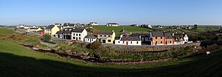
Doolin is a coastal village in County Clare, Ireland, on the Atlantic coast. It is southwest of the spa town of Lisdoonvarna and 4 miles from the Cliffs of Moher. It is a noted centre of traditional Irish music, which is played nightly in its pubs, making it a popular tourist destination. There are numerous nearby archaeological sites, many dating to the Iron Age and earlier. Doonagore Castle and Ballinalacken Castle are also in the area. The area was officially classified as part of the West Clare Gaeltacht prior to the 1950s, and maintains a connection with Irish-speaking areas - including via its maritime connection with the Aran Islands.
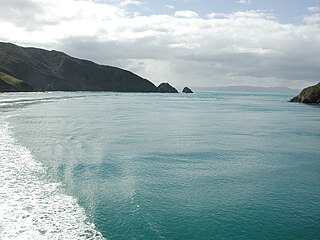
Tory Channel is one of the drowned valleys that form the Marlborough Sounds in New Zealand. Inter-island ferries normally use it as the principal channel between Cook Strait and the Marlborough Sounds.
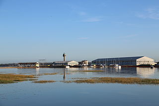
Calshot is a coastal village in Hampshire, England, at the west corner of Southampton Water where it joins the Solent.

Hutton Roof Crags is a hill in southeastern Cumbria in northwest England, located near to the village of Hutton Roof. It has extensive areas of limestone pavement as well as grassland and woodland. The hill forms the Hutton Roof Crags Site of Special Scientific Interest and is part of the Morecambe Bay Pavements Special Area of Conservation. A significant proportion of the UK's 20 km2 (7.7 sq mi) of limestone pavement is to be found on Hutton Roof Crags and the neighbouring Farleton Knott.
The Craigieburn Range forms part of the Southern Alps in New Zealand's South Island. The range is located on the south banks of the Waimakariri River, south of Arthur's Pass and west of State Highway 73. The Craigieburn locality is adjacent to the Craigieburn Forest Park.

Drewsteignton is a village, civil parish and former manor within the administrative area of West Devon, England, also lying within the Dartmoor National Park. It is located in the valley of the River Teign, 13 miles (21 km) west of Exeter and 9 miles (14 km) south east of Okehampton. Visitor attractions in the area include the village centre itself, nearby Castle Drogo, and Fingle Bridge. The population of the ward at the 2011 census was 1,616.

A station or run, in the context of New Zealand agriculture, is a large farm dedicated to the grazing of sheep and cattle. The use of the word for the farm or farm buildings date back to the mid-nineteenth century. The owner of a station is called a runholder.
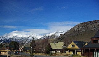
Castle Hill Village is an alpine village in Canterbury, New Zealand that started in 1982.

Maoricrambus is a genus of moths of the family Crambidae. It contains only one species, Maoricrambus oncobolus, which is endemic to New Zealand. This species is classified as Nationally Endangered by the Department of Conservation.
The Porter River is a river of the Canterbury Region of New Zealand's South Island. It rises close to the southern end of the Craigieburn Range east of Lake Coleridge, flowing generally northeast to reach the Broken River close to Castle Hill. The Porters Ski Area is above the river valley's western flank, and State Highway 73 follows the river's course for some distance to the west of Porters Pass.

State Highway 73 is a major east-west South Island state highway in New Zealand connecting Christchurch on the east coast with Cass/Hokitika via the Southern Alps. It is mostly two lane, with some single-lane bridges north of Springfield but is mostly dual carriageway in Christchurch. The fourth and fifth-highest points of New Zealand's state highway network are on this road at Porters Pass and Arthur's Pass respectively.
Flock Hill station is located in New Zealand's South Island high country, in the Waimakariri River basin, 75 minutes drive from Christchurch on State Highway 73 which is now commonly known as The Great Alpine Highway between Castle Hill Station and Cass near Lake Pearson.
Bouldergaine is a sport that combines bouldering and rogaining.

The Georgian S11 route, also known as Akhaltsikhe - Ninotsminda , is a "road of international importance" within the Georgian system and runs from Akhaltsikhe via Akhalkalaki to the border with Armenia near Ninotsminda covering 112 kilometres (70 mi). After crossing the Georgia–Armenia border the highway continues as M1 to Gyumri, Armenia's second largest city. The entire two-lane S11 is part of the European E691 and Asian AH82 routes and connects with two other Georgian S-highways. The road is located entirely in the Samtskhe–Javakheti region which is geographically an extension of the Armenian Highlands, and reaches a maximum altitude of 2,150 metres (7,050 ft) above sea level without passing any mountain passes. The high altitude plains between Akhalkalaki and the Armenian border have a harsh winter climate, leading to frequent road closures due to high snow.

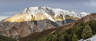
Mount Peel is a mountain located in South Canterbury, New Zealand. It consists of three peaks, Mount Peel, Middle Mt Peel and Little Mt Peel/Huatekerekere. Mt Peel is 1,743 metres (5,719 ft) tall and is owned by the Department of Conservation and Mt Peel Station. It lies just south of the Rangitata river and is 22 kilometres (14 mi) north-west of Geraldine.
Kakahu is a locality in the Canterbury region in the South Island of New Zealand. It is located about 22 kilometers (13.6 mi) west of Geraldine. It is well known for its rich historical and geological history.

Korowai / Torlesse Tussocklands Park is a protected area in Canterbury, New Zealand. Covering around 21,000 hectares, it is located on both sides of State Highway 73, from east of Porters Pass to south of Castle Hill Village.

Harboro' Rocks is a dolomitic limestone hill near the village of Brassington in the Derbyshire Peak District. The summit is 379 metres (1,243 ft) above sea level with views across to Carsington Water.


