
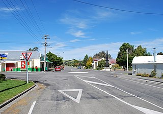
Amberley is a town located in the Hurunui District in north Canterbury, on the east coast of the South Island of New Zealand. It is located on State Highway 1 approximately 50 km north of Christchurch. It is the seat of the Hurunui District Council. The nearest town to the north of Amberly via state highway one is Waipara (11 km) and the nearest town to the south is Leithfield (5.7 km).

Heathcote Valley is a suburb of Christchurch, New Zealand. It is named after Sir William Heathcote, who was secretary of the Canterbury Association.

Kirwee is a town located west of Christchurch in the Canterbury region of New Zealand's South Island. It was named after Karwi in India by retired British Army colonel De Renzie Brett. Kirwee is also home to the South Island Agricultural Field Days, held biennially.
Hawarden is a small town in the Canterbury region of New Zealand's South Island. It is located near Waikari, just off State Highway 7.

Loburn is a rural community in North Canterbury, New Zealand. It is located ten kilometres northwest of Rangiora and nearly 50 kilometres north of Christchurch.
Waikuku is a small town in the Canterbury region of New Zealand, which sits 28 km north of central Christchurch. Waikuku lies 11.8 km (7.3 mi) south of Leithfield on state highway 1 and 3 km (1.9 mi) north of Woodend. In 1901 there were 86 people resident in Waikuku according to that year's census. Waikuku settlement had a population of 156 people at the time of the 2018 Census. It is popular with both those that commute into work in Christchurch each day and with owners of holiday houses. Waikuku was home to rope and twine works. This business started off using flax from local swamps. It closed in 1987. The nearby sandy beach and pine forests are popular with surfers, swimmers, campers and horse-riders, and the large estuary of the Ashley River hosts many species of birds.

Cust is a rural village in the South Island of New Zealand. It is located in North Canterbury and comes under seat of the Waimakariri District Council. It is located approximately 16 km east of Oxford and 17 km west of Rangiora. The town is named after Sir Edward Cust, who was a member of the Canterbury Association which organised European settlement of the area around 1850. Earlier names for the town were Moeraki Downs and Middleton-on-the-Cust.

Timaru District is a local government district on New Zealand's South Island, administered by the Timaru District Council. It is part of the larger Canterbury Region. Timaru district was formed in 1989 from the amalgamation of Timaru City, Geraldine borough, Temuka borough and Strathallan County.

Ashburton District is a territorial authority district in the Canterbury Region of the South Island of New Zealand. It encompasses the town of Ashburton, a number of small towns and settlements and the surrounding rural area, roughly coterminous with Mid Canterbury. The district had a population of 38,400 as of June 2024.

Hororata is a village at the northwestern edge of the Canterbury Plains in the South Island of New Zealand. It is located 15 kilometres southwest of Darfield, five kilometres south of Glentunnel, and 50 kilometres west of Christchurch, on the banks of the Hororata River. Hororata, when translated from Maori means "drooping rata". There are a large number of rata growing in the district.

Governors Bay is a small town in Canterbury, New Zealand.

Wainoni is one of the eastern suburbs of Christchurch. It is a lower socio-economic area.
Okuku is a small farming community located in North Canterbury, New Zealand, lying 20 kilometres northwest of Rangiora. Okuku consists of a mix of flat and undulating farmland, and river beds that drain a catchment area in the foothills to the north. Okuku is bounded to the south by the Ashley River / Rakahuri, to the east by the Okuku River, and to the west by the Garry River. Mount Thomas is the highest point at a height of 1023m.

Gisborne Central is the central business district and central suburb of Gisborne, in the Gisborne District of New Zealand's North Island. It is located east of Elgin, south of Whataupoko and west of Kaiti.

Fordell is a rural community in the Whanganui District and Manawatū-Whanganui region of New Zealand's North Island. It is on the Marton-New Plymouth railway line east of Kaitoke and north of Whangaehu.

Tasman is a settlement in the Tasman District of New Zealand's upper South Island. It is located between Māpua and Motueka, 45 kilometres (28 mi) from Abel Tasman National Park and 40 kilometres (25 mi) from Nelson.

Waimataitai is a suburb of Timaru, in the South Canterbury district and Canterbury region of New Zealand's South Island.

Parkside is a suburb of Timaru, in the Timaru District and Canterbury Region of New Zealand's South Island.
Fairview is a rural community in the Timaru District, New Zealand. It is located southwest of Timaru.
Makikihi is a small town in the Waimate District of south Canterbury region of New Zealand's South Island. It is located on State Highway 1 12.2 kilometres south of Saint Andrews, Canterbury, and 15.5 kilometres northeast of Waimate. It is close to the mouth of Makikihi River.
