Mount Hutt rises to the west of the Canterbury Plains in the South Island of New Zealand, above the braided upper reaches of the Rakaia River, and 80 kilometres west of Christchurch. Its summit is 2190 metres above sea level.

Nelson Lakes National Park is in the South Island of New Zealand, at the northern end of the Southern Alps. It was created in 1956. The park contains beech forests, multiple lakes, snow-covered mountains and valleys created by glaciers during the ice ages.
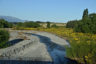
The Rubicon River is a minor river in the South Island of New Zealand. It starts on the southeast flanks of the Torlesse Range and feeds into the Kowai River.

Craigieburn is the name of a settlement and several geographic features in northwest Canterbury, in New Zealand's South Island.

Mount Hikurangi is a 1,752 m (5,748 ft) peak in the eastern corner of New Zealand's North Island, about 80 kilometres (50 mi) north of Gisborne, and 50 kilometres (31 mi) southwest of the East Cape Lighthouse. On a spur of the Raukumara Range in the Waiapu Valley, it is the North Island's highest non-volcanic peak.
Conservation park is a type of specially protected status for land held by the Crown in New Zealand for conservation purposes. The status is set up under the Conservation Act 1987 and the parks are administered by the Department of Conservation (DoC).

Lake Lyndon is a small lake in the Canterbury region of New Zealand's South Island. It is located near Porters Pass on State Highway 73 after Springfield heading into the Southern Alps. The lake regularly freezes in winter due to its elevation and location on the outer border of the Southern Alps.
Porters Pass is a mountain pass in the Canterbury region of New Zealand's South Island.

Porters, is a commercial ski resort just over an hour's drive (98 km) west from Christchurch, in the South Island of New Zealand. Originally functioning as a club skifield, it has one beginner magic carpet, one platter tow, one chairlift and three t-bars. The difficulty of the slopes is distributed as 15% beginner, 35% intermediate and 50% advanced. Modern grooming equipment is used, and snowmaking facilities operate along the main pistes along the chairlift.

Craigieburn Forest Park is a protected area in the South Island of New Zealand, adjacent to Arthur's Pass National Park to the north.
The Little Kowai River is a river of the Canterbury region of New Zealand's South Island. It flows generally south from the Torlesse Range to join with the Kowai River two kilometres north of Springfield.
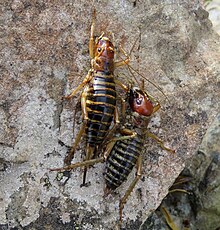
Sigaus villosus is New Zealand's largest grasshopper. It is only found in the central mountains of the South Island. The genus Sigaus is endemic to the New Zealand. Like all of New Zealand sub-alpine and alpine grasshoppers S. villosus has a 2 or 3 years life cycle. The eggs must ‘overwinter’ before they will hatch. Hoppers are found throughout the year and adult grasshoppers can be found throughout the New Zealand summer between December and April. Adult S. villosus do not overwinter.

Sigaus australis is the most common alpine grasshopper found in New Zealand. It can be found in the southern half of the South Island above the tree line. Sigaus australis was described in 1897 by Frederick Hutton. Like all of New Zealand sub-alpine and alpine grasshoppers S. australis has a 2 or 3 years life cycle. Individuals can survive the cold by freezing solid at any life stage, at any time of the year. Sigaus australis adults are relatively large grasshoppers. The genus Sigaus is endemic to New Zealand.

The Ashburton River / Hakatere is a river in the Canterbury region of New Zealand, flowing across Mid Canterbury from the Southern Alps to the Pacific Ocean. The official name of the river was amended to become a dual name by the Ngāi Tahu Claims Settlement Act 1998. It has been identified as an Important Bird Area by BirdLife International because it supports breeding colonies of the endangered black-billed gull.
The Kowai River is a river in the Canterbury region of New Zealand. It rises on the southern flanks of the Torlesse Range and travels south, emerging from the foothills of the Southern Alps near Springfield. The river turns east across the upper Canterbury Plains before joining the Waimakariri River. State Highway 73 follows the river as it climbs towards Porters Pass.

Mount Peel is a mountain located in South Canterbury, New Zealand. It consists of three peaks, Mount Peel, Middle Mt Peel and Little Mt Peel/Huatekerekere. Mt Peel is 1,743 metres (5,719 ft) tall and is owned by the Department of Conservation and Mt Peel Station. It lies just south of the Rangitata river and is 22 kilometres (14 mi) north-west of Geraldine.

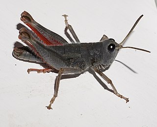
Maoricicada cassiope, also known as the screaming cicada, is a species of insect that is endemic to New Zealand. This species was first described by George Hudson in 1891. Maoricicada cassiope can be found in mountainous regions of the North and upper South Island.

Te Korowai-o-Te-Tonga Peninsula, also known as South Head and by its former name of the South Kaipara Peninsula, is a long peninsula in the North Island of New Zealand, extending north along the western edge of the Kaipara Harbour for some 35 kilometres (22 mi) from near Helensville to the harbour's mouth. The peninsula was officially renamed in 2013 as part of a Treaty of Waitangi settlement. The name, which is Māori for "The cloak of the south", reflects the peninsula's geographical role in guarding the southern half of the Kaipara Harbour from the Tasman Sea and prevailing westerly winds. The mouth of the Kaipara Harbour separates the peninsula from the larger Pouto Peninsula to the north.

Hakatere Conservation Park is a protected area between the Rakaia River and the Rangitata River in the Ashburton District of New Zealand. The park was established in 2007. It covers 60,000 hectares of rugged mountains and mountain basins, tussocklands and beech forest. It includes the Ashburton Lakes, such as Lake Heron and Lake Clearwater, popular tramping area Mount Somers / Te Kiekie, and Mount Hutt skifield. The closest town is Mount Somers.

Muriwai Regional Park is a regional park located in Muriwai on the west coast of the Auckland Region of New Zealand's North Island. It is situated in Rodney north-west of Auckland and is owned and operated by Auckland Council.