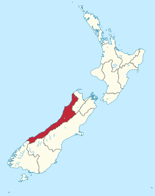
The West Coast is a region of New Zealand on the west coast of the South Island. It is administered by the West Coast Regional Council, and is known co-officially as Te Tai Poutini. It comprises the territorial authorities of Buller District, Grey District and Westland District. The principal towns are Westport, Greymouth and Hokitika. The region, one of the more remote areas of the country, is also the most sparsely populated. With a population of just 32,900 people, the West Coast is the least populous region in New Zealand. The population in the region grew by 0.4% over the year to July 2023.

Paparoa National Park is on the west coast of the South Island of New Zealand. The park was established in 1987 and encompasses 430 km2 (170 sq mi). The park ranges from or near the coastline to the peaks of the Paparoa Range. A separate section of the park lies to the north and is centred at Ananui Creek. The park protects a limestone karst area. The park contains several caves, of which Metro Cave / Te Ananui Cave is a commercial tourist attraction. The majority of the park is forested with a wide variety of vegetation. The park was the site of the 1995 Cave Creek disaster where fourteen people died as a result of the collapse of a scenic viewing platform.
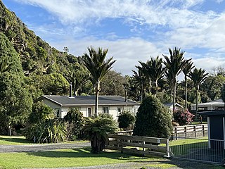
Punakaiki is a small village on the West Coast of the South Island of New Zealand. It is located between Westport and Greymouth on State Highway 6, the only through-road on the West Coast. Punakaiki is immediately adjacent to Paparoa National Park, and is also the access point for a popular visitor attraction, the Pancake Rocks and Blowholes.

New Zealand has 44 marine reserves spread around the North, the South Island, and neighbouring islands, and on outlying island groups. They are governed by the Marine Reserves Act 1971 and administered by the Department of Conservation with assistance from the Ministry for Primary Industries, New Zealand Customs Service and the New Zealand Defence Forces.
Hawea Marine Reserve is a marine reserve covering an area of 411 hectares in Hāwea / Bligh Sound, in Fiordland on New Zealand's South Island. It was established in 2005 and is administered by the Department of Conservation.

Hikurangi Marine Reserve is a marine reserve off the coast of the Kaikōura District, in the Canterbury Region of New Zealand's South Island. It is the largest and deepest marine reserve in New Zealand.

Waiau Glacier Coast Marine Reserve is a marine reserve of the West Coast Region of New Zealand's South Island. It covers an area of 4,641 hectares or 46 km2, from 11 km south from Kohuamarua Bluff near Ōkārito, to Omoeroa Bluff, and about 4 km out to sea.

Moutere Ihupuku / Campbell Island Marine Reserve or Campbell Island / Moutere Ihupuku Marine Reserve is a marine reserve around Campbell island in the New Zealand Subantarctic Islands.

Kahurangi Marine Reserve is a marine reserve administered by the Department of Conservation, covering 8,419 hectares offshore of Kahurangi National Park in the Buller District of New Zealand's West Coast Region.

Cave Creek / Kotihotiho is a small river within Paparoa National Park, on the West Coast of New Zealand's South Island.

Tauparikākā Marine Reserve is a marine reserve located offshore about 20 kilometres (12 mi) north of Haast on the West Coast of New Zealand's South Island. It covers the area immediately offshore from Ship Creek, which is also known as Tauparikākā in Māori.
Kahukura Marine Reserve is a marine reserve covering an area of 464 hectares in Charles Sound, in Fiordland on New Zealand's South Island. It was established in 2005 and is administered by the Department of Conservation.

Taumoana Marine Reserve is a marine reserve covering an area of 464 hectares in Fiordland on New Zealand's South Island. It was established in 2005 and is administered by the Department of Conservation. It is located next to the Five Fingers Peninsula, at the entrance to Tamatea / Dusky Sound.

Te Tapuwae o Hua Marine Reserve is a marine reserve covering an area of 3,672 hectares in Te Awaroa / Long Sound in Fiordland on New Zealand's South Island. It was established in 2005 and is administered by the Department of Conservation.
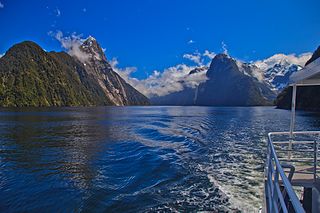
Piopiotahi Marine Reserve is a marine reserve covering an area of 690 hectares in the Milford Sound / Piopiotahi, in Fiordland on New Zealand's South Island. It was established in 1993 and is administered by the Department of Conservation.
Sutherland Sound Marine Reserve is a marine reserve covering an area of 449 hectares of Sutherland Sound / Sutherland Sound, in Fiordland on New Zealand's South Island. It was established in 2005 and is administered by the Department of Conservation.

Te Awaatu Channel Marine Reserve is a marine reserve covering an area of 93 hectares in Fiordland on New Zealand's South Island. It was established in 1993 and is administered by the Department of Conservation.
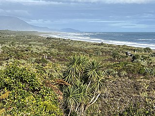
The Barrytown Flats are a 17 km (11 mi) coastal plain north of Greymouth on the West Coast of New Zealand's South Island. A series of postglacial shorelines and dunes backed by a former sea cliff, they was originally covered with wetland and lowland forest, including numerous nīkau palms. The sands were extensively sluiced and dredged for gold from the 1860s, centred on the small settlement of Barrytown. The drier areas of the flats have been converted into pasture, but significant areas of forest remain, including Nikau Scenic Reserve. The flats are bordered by Paparoa National Park and the only breeding site of the Westland petrel. There are significant deposits of ilmenite in the Barrytown sands, and there have been several mining proposals, but the possible environmental consequences have been contentious.

The Truman Track is a short, easy walking track located north of Punakaiki, in the coastal Paparoa National Park in the South Island of New Zealand. Although only 600 m (2,000 ft) long, it has been described as "one of the most delightful and interesting short walks on the West Coast". The track passes through lowland coastal forest of podocarps, rātā trees and nīkau palms, with dense understorey vegetation. It finishes at the coastline, where there is a viewing platform providing views along the coast, with surrounding cliffs, rock overhangs, and a waterfall that cascades directly onto the beach.

The Pancake Rocks and Blowholes are a coastal rock formation at Punakaiki on the West Coast of the South Island of New Zealand. They are a popular visitor attraction.