Related Research Articles

Canterbury is a region of New Zealand, located in the central-eastern South Island. The region covers an area of 44,503.88 square kilometres (17,183.04 sq mi), making it the largest region in the country by area. It is home to a population of 666,300.
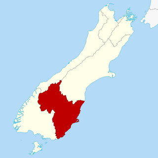
Otago is a region of New Zealand located in the southern half of the South Island administered by the Otago Regional Council. It has an area of approximately 32,000 square kilometres (12,000 sq mi), making it the country's second largest local government region. Its population was 254,600 in June 2023.

Hawke's Bay is a region on the east coast of New Zealand's North Island. The region is named for Hawke Bay, which was named in honour of Edward Hawke. The region's main centres are the cities of Napier and Hastings, while the more rural parts of the region are served by the towns of Waipukurau, Waipawa, and Wairoa.
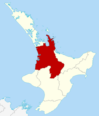
Waikato is a region of the upper North Island of New Zealand. It covers the Waikato District, Waipa District, Matamata-Piako District, South Waikato District and Hamilton City, as well as Hauraki, Coromandel Peninsula, the northern King Country, much of the Taupō District, and parts of the Rotorua Lakes District. It is governed by the Waikato Regional Council.

The Waikato River is the longest river in New Zealand, running for 425 kilometres (264 mi) through the North Island. It rises on the eastern slopes of Mount Ruapehu, joining the Tongariro River system and flowing through Lake Taupō, New Zealand's largest lake. It then drains Taupō at the lake's northeastern edge, creates the Huka Falls, and flows northwest through the Waikato Plains. It empties into the Tasman Sea south of Auckland, at Port Waikato. It gives its name to the Waikato region that surrounds the Waikato Plains. The present course of the river was largely formed about 17,000 years ago. Contributing factors were climate warming, forest being reestablished in the river headwaters and the deepening, rather than widening, of the existing river channel. The channel was gradually eroded as far up river as Piarere, leaving the old Hinuera channel through the Hinuera Gap high and dry. The remains of the old course are seen clearly at Hinuera, where the cliffs mark the ancient river edges. The Waikato's main tributary is the Waipā River, which converges with it at Ngāruawāhia.

Whanganui, also spelt Wanganui, is a city in the Manawatū-Whanganui region of New Zealand. The city is located on the west coast of the North Island at the mouth of the Whanganui River, New Zealand's longest navigable waterway. Whanganui is the 19th most-populous urban area in New Zealand and the second-most-populous in Manawatū-Whanganui, with a population of 42,800 as of June 2023.

The Clutha River is the second longest river in New Zealand and the longest in the South Island. It flows south-southeast 338 kilometres (210 mi) through Central and South Otago from Lake Wānaka in the Southern Alps to the Pacific Ocean, 75 kilometres (47 mi) south west of Dunedin. It is the highest volume river in New Zealand, and the swiftest, with a catchment of 21,000 square kilometres (8,100 sq mi), discharging a mean flow of 614 cubic metres per second (21,700 cu ft/s). The river is known for its scenery, gold-rush history, and swift turquoise waters. A river conservation group, the Clutha Mata-Au River Parkway Group, is working to establish a regional river parkway, with a trail, along the entire river corridor.
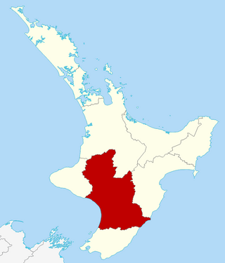
Manawatū-Whanganui is a region in the lower half of the North Island of New Zealand, whose main population centres are the cities of Palmerston North and Whanganui. It is administered by the Manawatū-Whanganui Regional Council, which operates under the name Horizons Regional Council.

The Waitaki River is a large braided river in the South Island of New Zealand. It drains the Mackenzie Basin and runs 209 kilometres (130 mi) south-east to enter the Pacific Ocean between Timaru and Oamaru on the east coast. It starts at the confluence of the Ōhau and Tekapo rivers, now at the head of the artificial Lake Benmore, these rivers being fed by three large glacial lakes, Pukaki, Tekapo, and Ōhau at the base of the Southern Alps. The Waitaki flows through Lake Benmore, Lake Aviemore and Lake Waitaki, these lakes being contained by hydroelectric dams, Benmore Dam, Aviemore Dam and Waitaki Dam. The Waitaki has several tributaries, notably the Ahuriri River and the Hakataramea River. It passes Kurow and Glenavy before entering the Pacific Ocean. The River lends its name the Waitaki District on the south side of the river bank.

Kahurangi National Park in the northwest of the South Island of New Zealand is the second largest of the thirteen national parks of New Zealand. It was gazetted in 1996 and covers 5,193 km2 (2,005 sq mi), ranging from the Buller River near Murchison in the south, to the base of Farewell Spit in Golden Bay in the north. The park has no single dominant landform, but includes an unusually wide variety of landscapes, including mountain ranges, rivers, gorges, raised peneplains and karst features such as caves and arches. Many of the landforms within the park are considered to be nationally or internationally significant.
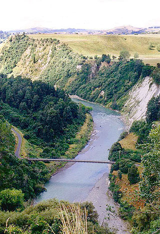
The Rangitīkei River is one of New Zealand's longest rivers, 253 kilometres (157 mi) long.

The Taieri River is the fourth-longest river in New Zealand and is in Otago in the South Island. Rising in the Lammerlaw Range, it initially flows north, then east around the Rock and Pillar range before turning southeast, reaching the sea 30 kilometres (19 mi) south of Dunedin.

The Clarence River is a major river which flows through the Kaikōura Ranges in the northeast of New Zealand's South Island. At roughly 209 kilometres (130 mi) long, it is the longest river in Canterbury and the eighth longest in New Zealand.

The Manawatū River is a major river of the lower North Island of New Zealand. The river flows from the Ruahine Ranges, through both the Manawatū Gorge and the city of Palmerston North, and across the Manawatū Plains to the Tasman Sea at Foxton.

The Whanganui River is a major river in the North Island of New Zealand. It is the country's third-longest river, and has special status owing to its importance to the region's Māori people. In March 2017 it became the world's second natural resource to be given its own legal identity, with the rights, duties and liabilities of a legal person. The Whanganui Treaty settlement brought the longest-running litigation in New Zealand history to an end.

The Zealand River is a 6.3-mile-long (10.1 km) river in the White Mountains of New Hampshire in the United States. It is a tributary of the Ammonoosuc River and part of the Connecticut River watershed.

Lower Hutt is a city in the Wellington Region of New Zealand. Administered by the Hutt City Council, it is one of the four cities that constitute the Wellington metropolitan area.
The Pike River Mine disaster was a coal mining accident that began on 19 November 2010 in the Pike River Mine, 46 km (29 mi) northeast of Greymouth, in the West Coast region of New Zealand's South Island following a methane explosion at approximately 3:44 pm. The accident resulted in the deaths of 29 miners.
References
- Land Information New Zealand - Search for Place Names