The Beardmore Glacier in Antarctica is one of the largest valley glaciers in the world, being 200 km (125 mi) long and having a width of 40 km (25 mi). It descends about 2,200 m (7,200 ft) from the Antarctic Plateau to the Ross Ice Shelf and is bordered by the Commonwealth Range of the Queen Maud Mountains on the eastern side and the Queen Alexandra Range of the Central Transantarctic Mountains on the western. Its mouth is east of the Lennox-King Glacier. It is northwest of the Ramsey Glacier.

Karamea is a town on the West Coast of the South Island of New Zealand. It is the northernmost settlement of any real size on the West Coast, and is located 96 kilometres (60 mi) northeast by road from Westport. Apart from a narrow coastal strip, the town of Karamea and its local area are completely surrounded to the south, east and north by Kahurangi National Park.

The Nimrod Glacier is a major glacier about 85 nautical miles long, flowing from the polar plateau in a northerly direction through the Transantarctic Mountains into the Ross Ice Shelf, Antarctica.
Kahurangi Point is a headland on the West Coast of New Zealand's South Island, overlooking the Tasman Sea. It is located in Kahurangi National Park between Karamea and Farewell Spit.
The Commonwealth Range is a north-south trending range of rugged mountains, 60 nautical miles long, located within the Queen Maud Mountains on the Dufek Coast of the continent of Antarctica. The range borders the eastern side of Beardmore Glacier from Keltie Glacier to the Ross Ice Shelf. The range is southeast of the Queen Alexandra Range, which is to the west of the Beardmore Glacier. It is west of the Hughes Range and north of the Supporters Range and the Barton Mountains.
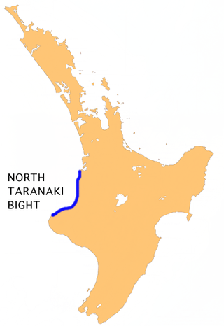
The North Taranaki Bight is a large bay that extends north and east from the north coast of Taranaki in New Zealand's North Island. The name is echoed by the South Taranaki Bight to the south of Cape Egmont.
The Manawatu Plains is an area of low-lying land in New Zealand, located on the floodplains of the Manawatū and Rangitīkei Rivers. It is some of the most fertile lands in the southwestern North Island.

Arapito is a town in the Karamea area of New Zealand. Arapito is a farming community on the south side of the Karamea River, upriver from the main Karamea township.
The Waimangaroa River is located on the West Coast of New Zealand.
Alasheyev Bight is a bight in the western part of the coast of Enderby Land. Kirkby Head is a sheer coastal outcrop on Tange Promontory, at the east side of the entrance to Alasheyev Bight. Alasheyev Bight was photographed from the air by Australian National Antarctic Research Expeditions in 1956. Plotted in 1957 by the Soviet Antarctic Expedition and named for D.A. Alasheyev, Russian hydrographer.
The Hae Hae Te Moana River is a river in the Canterbury region of New Zealand. It originates in the Four Peaks Range of the Southern Alps, with a North Branch and South Branch merging to the north of Pleasant Valley. The river runs south-east to join the Waihi River near Winchester. The combined river is called the Temuka River, which flows past Temuka to join the Ōpihi River shortly before it runs into the Canterbury Bight.

The Little Wanganui River is a river of the West Coast Region of New Zealand's South Island. It flows generally west from the slopes of Mount Allen, reaching the Karamea Bight close to the small settlement of Little Wanganui. It is home to a large number of trout.

The Orowaiti River is a river of the West Coast Region of New Zealand's South Island. The smaller of the two rivers which run through the town of Westport, it reaches the Karamea Bight three kilometres to the east of its larger neighbour, the Buller River.

Nurina Land District is a land district of Western Australia, located within the Eucla Land Division on the Nullarbor Plain. It spans roughly 31°00'S - 32°20'S in latitude and 125°30'E - 127°30'E in longitude.

The Westport News is an independently-owned evening newspaper published in Westport, New Zealand. It is published on weekdays, and is one of New Zealand's smallest independent newspapers. The Westport News is distributed from Karamea in the north to Punakaiki in the south and as far inland as Reefton.

Karamea Centennial Museum is a museum in Karamea on the West Coast of the South Island of New Zealand.

Coast FM is a local radio station in Westport, New Zealand, to most of the West Coast Region. The station began in 1995 as Radio Fifeshire Westport in partnership with Fifeshire FM in Nelson, and started broadcasting in Hokitika and Greymouth in 1996. The station was rebranded as Coast FM in 1999, but is not related to Coast network that broadcasts in other parts of the country. It used to broadcast from the Westport News offices in the former BNZ building on Palmerston Street.

Ōtūmahana Estuary, also known as the Karamea Estuary, is a tidal estuary in the Buller District of the West Coast Region of New Zealand. It is located at the mouth of the Karamea River and also receives the outflow of Ōtūmahana creek.

The Big Rimu Walk is a nature trail near Karamea, located in Kahurangi National Park on the West Coast of the South Island of New Zealand. A short walk of 1.1 kilometres (0.68 mi) through regenerating bush leads to a large rimu tree that is 36 metres (118 ft) tall with a trunk over two metres in diameter and estimated to be over 1,000 years old. Other smaller rimu in the area were logged during the 1940s but this large tree was left.

Umere is a town in the Karamea area of New Zealand. Umere is a farming community on the north side of the Karamea River, upriver from the main Karamea township.
