It was the site of a punt that connected Westport to the south bank before the "black bridge" was constructed at Westport itself. State Highway6 runs on the southern bank of the river, and the Stillwater - Westport Linerailway runs on the northern bank. This railway was opened to Te Kuha from Westport in 1912, but a connection through the Buller Gorge to connect with the railway in Inangahua Junction was not completed until 1942. Passenger services no longer pass through Te Kuha and the railway mainly transports coal to the east coast port of Lyttelton.[citation needed]
There is not much evidence that the village at Te Kuha even existed now in 2023. The road ends as the railway enters the Buller Gorge, and the surrounding flats are used for farming. There are no building remains, and further access on the railway side of the Buller river is discouraged by the railway activity. Although this point was the punt crossing in the early days for the road on the south bank at Windy Point, the building of the black bridge across the Buller spelt the death knell of Te Kuha. However, the railway was opened as far as Cascade Creek where coal bins stored the coal flumed down from the Cascade Mine for loading into trains for shipment at Westport. During World War II the Government completed the Buller Gorge Railway in 1942 and finally connected the isolated "Westport section" to the rest of the South Island Railway system.[citation needed]
Te Kuha was classified as a "limited employment locality" in 2004, with the government cancelling benefits for unemployed individuals who moved to the area.[citation needed]
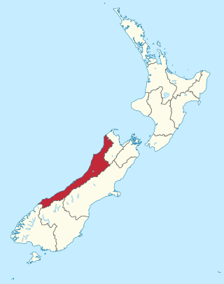
The West Coast is a region of New Zealand on the west coast of the South Island. It is administered by the West Coast Regional Council, and is known co-officially as Te Tai Poutini. It comprises the territorial authorities of Buller District, Grey District and Westland District. The principal towns are Westport, Greymouth and Hokitika. The region, one of the more remote areas of the country, is also the most sparsely populated. With a population of just 32,900 people, the West Coast is the least populous region in New Zealand. The population in the region grew by 0.4% over the year to July 2023.
The River Cherwell is a tributary of the River Thames in central England. It rises near Hellidon, Northamptonshire and flows southwards for 40 miles (64 km) to meet the Thames at Oxford in Oxfordshire.
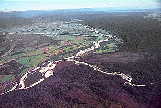
The Buller River is a river in the South Island of New Zealand. The Buller has the highest flow of any river in the country during floods, though it is only the 13th longest river; it runs for 177 km (110 mi) from Lake Rotoiti through the Buller Gorge and into the Tasman Sea near the town of Westport. A saddle at 710 m (2,330 ft) separates the Buller from the Motupiko River and that is divided from the Wairau River by a 695 m (2,280 ft) saddle, both aligned along the Alpine Fault, as is the top of the Buller valley.
Westport is a town in the West Coast region of the South Island of New Zealand. Established in 1861, it is the oldest European settlement on the West Coast. Originally named Buller, it is on the right bank and at the mouth of the Buller River, close by the prominent headland of Cape Foulwind. It is connected via State Highway 6 with Greymouth, 100 kilometres (62 mi) to the south, and with Nelson 222 kilometres (138 mi) in the northeast, via the Buller Gorge. The population of the Westport urban area was 4,250 as of June 2023. The Buller District had a population of 9,670.
The Taieri River is the fourth-longest river in New Zealand and is in Otago in the South Island. Rising in the Lammerlaw Range, it initially flows north, then east around the Rock and Pillar range before turning southeast, reaching the sea 30 kilometres (19 mi) south of Dunedin.
Inangahua is a small settlement in the northwest of New Zealand's South Island. It consists of three settled areas: Inangahua Junction at the confluence of the Inangahua and Buller Rivers, 34 kilometres (21 mi) north of Reefton and 46 kilometres (29 mi) southeast of Westport; Inangahua Landing, 10 km further up the Inangahua River; and Inangahua township, 2 km east of the Junction. Murchison is 52 kilometres (32 mi) further east. After the 1968 Inangahua Earthquake, most of the inhabitants left the area or shifted to the township, which is now the population centre and known simply as Inangahua.
The Buller Gorge is a gorge located in the northwest of the South Island of New Zealand. The Buller River flows through the deep canyon between Murchison and Westport. Land Information New Zealand lists two sections for the gorge, Upper Buller Gorge and Lower Buller Gorge. State Highway 6 runs alongside, but considerably above, the river through the gorge. The Stillwater - Westport Line railway also runs through the gorge.
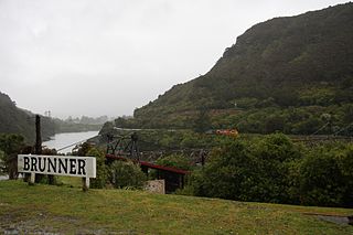
Brunner, originally called Brunnerton, is a town in the northwest of New Zealand's South Island. It is 12 kilometres (7 mi) east of Greymouth, on the south bank of the Grey River. It is on the Midland Line railway near its junction with the Stillwater–Westport Line (SWL) in neighbouring Stillwater. Passenger trains ceased running along the SWL to Reefton and Westport in 1967, but the TranzAlpine runs the length of the Midland Line from Christchurch to Greymouth and it continues to stop in Brunner.
U.S. Route 30 (US 30) in the U.S. state of Oregon is a major east–west United States Numbered Highway that runs from its western terminus in Astoria to the Idaho border east of Ontario. West of Portland, US 30 generally follows the southern shore of the Columbia River; east of Portland, the highway has largely been replaced with Interstate 84 (I-84), though it is signed all the way across the state, and diverges from the I-84 mainline in several towns as a de facto business route. Out of all the states US 30 traverses, it spends the most time in Oregon. At 477.02 miles (767.69 km), it is also the longest road in the state.
The Midland line is a 212 km section of railway between Rolleston and Greymouth in the South Island of New Zealand. The line features five major bridges, five viaducts and 17 tunnels, the longest of which is the Otira tunnel. It is the route of the popular TranzAlpine passenger train.
The Stillwater Ngākawau Line (SNL), formerly the Stillwater–Westport Line (SWL) and the Ngakawau Branch, is a secondary main line, part of New Zealand's national rail network. It runs between Stillwater and Ngakawau via Westport on the West Coast of the South Island. It was one of the longest construction projects in New Zealand's history, with its first section, at the south end, opened in 1889, and the beginnings of the Ngākawau Branch, at its Westport end, in 1875. The full line was completed in 1942. The only slower railway projects were Palmerston North to Gisborne, 1872 to 1942, and the Main North Line to Picton, 1872 to 1945.
Cronadun is a small village located in the West Coast region of New Zealand's South Island. It is situated on the east bank of the Inangahua River, near its junction with Boatmans Creek. SH 69 and the Stillwater–Westport Line railway pass through the village.
The Papahaua Range is a mountain range on the West Coast of New Zealand's South Island east of the town of Westport. It is a geological continuation of the Paparoa Range that is south of the Buller River and it runs north from the Buller Gorge to the Mōkihinui River. At its north end, it meets the Glasgow Range.
The Seddonville Branch, later truncated as the Ngākawau Branch, is a branch line railway in the West Coast region of New Zealand's South Island. Construction began in 1874 and it reached its terminus at the Mokihinui Mine just beyond Seddonville in 1895. In 1981 it was closed past Ngākawau and effectively became an extension of the Stillwater–Westport Line, since formalised as the Stillwater–Ngākawau Line.
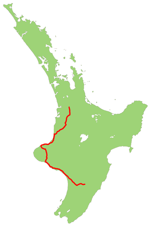
State Highway 6 is a major New Zealand state highway. It extends from the Marlborough region in the northeastern corner of the South Island across the top of the island, then down the length of the island, initially along the West Coast and then across the Southern Alps through inland Otago and finally across the Southland Plains to the island's south coast. Distances are measured from north to south.
State Highway 3 (SH 3) is one of New Zealand's eight national state highways. It serves the west coast of the country's North Island and forms a link between State Highway 1 and State Highway 2. Distances are measured from north to south.
The 1968 Inangahua earthquake struck 25 kilometres (16 mi) west of Murchison, New Zealand, near the small town of Inangahua Junction at 5:24 am NZDT on 24 May 1968. The earthquake had a moment magnitude of 7.1, a local magnitude of 6.7, a surface wave magnitude of 7.4 and a maximum Mercalli intensity of X (Exreme). It occurred at a depth of 12 kilometres (7.5 mi), being extremely shallow for an earthquake of its size. It resulted in the deaths of three people, with a further 14 people injured, making it the fifth deadliest earthquake in New Zealand's recorded history. Numerous aftershocks followed the quake, including 15 that were magnitude 5 or greater and occurred within a month.
The Koranui Incline was an inclined tramway on the West Coast of the South Island of New Zealand that, for four years from late 1882 to the end of 1886, brought coal from a mine high on Mt Frederick down to a railway line near sea level.
The Charming Creek Tramway was a 9 kilometres (5.6 mi) long private bush tramway at Ngakawau in Buller District on the West Coast in New Zealand. It was used from 1903 or 1905 to 1958.
Mount Rochfort is a mountain peak 1,040 metres (3,410 ft) in elevation, located approximately 10 km east of Westport in the Buller District on the West Coast of the South Island of New Zealand. It rises above the south-west portion of the Denniston Plateau and overlooks the town of Westport and the plains of the Buller River.
This page is based on this Wikipedia article Text is available under the CC BY-SA 4.0 license; additional terms may apply. Images, videos and audio are available under their respective licenses.