
The North Island, also officially named Te Ika-a-Māui, is one of the two main islands of New Zealand, separated from the larger but less populous South Island by Cook Strait. With an area of 113,729 km2 (43,911 sq mi), it is the world's 14th-largest island, constituting 43% of New Zealand's land area. It has a population of 3,997,300, which is 77% of New Zealand's residents, making it the most populous island in Polynesia and the 28th-most-populous island in the world.
Cook Strait is a strait that separates the North and South Islands of New Zealand. The strait connects the Tasman Sea on the northwest with the South Pacific Ocean on the southeast. It is 22 kilometres (14 mi) wide at its narrowest point, and is considered one of the most dangerous and unpredictable waters in the world. Regular ferry services run across the strait between Picton in the Marlborough Sounds and Wellington.

Taranaki is a region in the west of New Zealand's North Island. It is named after its main geographical feature, the stratovolcano Mount Taranaki, also known as Mount Egmont.
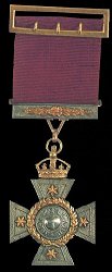
The New Zealand Cross was introduced in 1869 during the New Zealand Wars in New Zealand. The wars were fought between natives of New Zealand, the Māori, and forces raised by European settlers known as Pākehā assisted by British troops.

Shepherd's beaked whale, also commonly called Tasman's beaked whale or simply the Tasman whale, is a cetacean of the family Ziphiidae and the only species in the genus Tasmacetus. The whale has not been studied extensively. Only four confirmed at sea sightings have been made and 42 strandings recorded. It was first known to science in 1937, being named by W. R. B. Oliver after George Shepherd, curator of the Wanganui Museum, who collected the type specimen near Ohawe on the south Taranaki coast of New Zealand's North Island, in 1933.

Kahurangi National Park in the northwest of the South Island of New Zealand is the second largest of the thirteen national parks of New Zealand. It was gazetted in 1996 and covers 5,193 km2 (2,005 sq mi), ranging from the Buller River near Murchison in the south, to the base of Farewell Spit in Golden Bay in the north. The park has no single dominant landform, but includes an unusually wide variety of landscapes, including mountain ranges, rivers, gorges, raised peneplains and karst features such as caves and arches. Many of the landforms within the park are considered to be nationally or internationally significant.

Farewell Spit is a narrow sand spit at the northern end of the Golden Bay, in the South Island of New Zealand. The spit includes around 25 km (16 mi) of stable land and another 5 km (3.1 mi) of mobile sand spit running eastwards from Cape Farewell, the northern-most point of the South Island. Farewell Spit is the longest sand spit in New Zealand, and is a legally protected Nature Reserve. The area is designated as a Ramsar wetland site and an East Asian–Australasian Flyway Shorebird Network site. Farewell Spit is administered by the Department of Conservation as a seabird and wildlife reserve. Apart from a small area at the base of the spit, it is closed to the public except through organised tours. Conservation initiatives are in progress towards eliminating mammalian predators from Farewell Spit, including a proposal for a predator-proof fence.

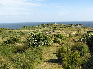
Cape Foulwind is a headland on the West Coast of the South Island of New Zealand, overlooking the Tasman Sea. It is located 11 kilometres (6.8 mi) west of the town of Westport. There is a lighthouse located on a prominent site on the headland. A walkway beginning at the lighthouse carpark traverses the rocky headland to Tauranga Bay and passes close by a colony of New Zealand fur seals. There is limestone quarry in the area, and a cement works operated nearby from 1958 to 2016.

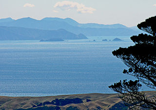
The South Taranaki Bight is a large bay on the west coast of New Zealand, south of Taranaki, west of the Manawatu, north and west of the western entrance of Cook Strait and north of the South Island. The name is sometimes used for a much smaller bay in South Taranaki, between the mouth of the Kaupokonui Stream directly south of Mount Taranaki and the mouth of the Pātea River.
Puysegur Point is a headland located in the far southwest of the South Island of New Zealand. It lies within Fiordland National Park on the southern head of Preservation Inlet and is 145 kilometres (90 mi) west-northwest of Invercargill. The name 'Puysegur' was bestowed by Lieutenant Jules Dumont d'Urville or Midshipman Jules de Blosseville during a South Pacific expedition of La Coquille; probably in honour of the French naval officer Antoine-Hyacinthe-Anne de Chastenet de Puységur (1752–1809).

The Tasman Island, part of the Tasman Island Group, is an oval island with an area of 1.2 square kilometres (0.46 sq mi), lying close to the south-eastern coast of Tasmania, Australia. The island is located in the Tasman Sea, situated off the Tasman Peninsula and is contained within the Tasman National Park.

The Sugar Loaf Islands are a collection of five small uninhabited islands and several sea stacks near Port Taranaki, New Zealand.

The Tangahoe River is a river of the Taranaki Region of New Zealand's North Island. It flows generally southwest from its origins in hill country to the east of Lake Rotorangi, reaching the Tasman Sea in the South Taranaki Bight 5 km (3.1 mi) southeast of Hawera.
Golden Bay is a large shallow bay in New Zealand's Tasman District, near the northern tip of the South Island. An arm of the Tasman Sea, the bay lies northwest of Tasman Bay and Cook Strait. It is protected in the north by Farewell Spit, a 26 km long arm of fine golden sand that is the country's longest sandspit. The Aorere and Tākaka rivers are the major waterways to flow into the bay from the south and the west.

Whale watching in New Zealand is predominantly centred around the areas of Kaikōura and the Hauraki Gulf. Known as the 'whale capital', Kaikōura is a world-famous whale watching site, in particular for sperm whales which is currently the most abundant of large whales in New Zealand waters. The Hauraki Gulf Marine Park is also a significant whale watching area with a resident population of Bryde's Whales commonly viewed alongside other cetaceans Common Dolphins, Bottlenose Dolphins and Orca. Whale watching is also offered in other locations, often as eco-tours and in conjunction with dolphin watching. Land-based whale watching from New Zealand's last whaling station, which closed in 1964, is undertaken for scientific purposes, mostly by ex-whalers.

Wainui Bay is within Golden Bay / Mohua, and at the south-eastern end of Golden Bay, in the Tasman Region of the South Island, New Zealand.

The Stephens Island / Takapourewa lighthouse is one of New Zealand most powerful lights with a range of 18 nautical miles. Perched 183 metres (600 ft) up, on top of Stephens Island, it guards Cook Strait and Tasman Bay / Te Tai-o-Aorere, at the top of the South Island / Te Wai Pounamu.The light flashes white once every six seconds from a white cast iron tower.

Whangaehu is a settlement in the Rangitikei District and Manawatū-Whanganui region of New Zealand's North Island.

Parininihi Marine Reserve is a marine reserve administered by the Department of Conservation, covering 1,800 hectares in the North Taranaki Bight. It is located offshore of the west coast of New Zealand's North Island, north-east of New Plymouth.
Trans-Tasman Resources (TTR) is an Australian mining company, wholly owned since 2023 by another Australian mining company Manuka Resources. TTR has been involved in court proceedings in New Zealand related to proposed seabed mining off the Taranaki coast.
