Abel Lake was a small lake in the Westland region of the South Island of New Zealand. It was located in the Southern Alps, 35 kilometres (22 mi) east of Franz Josef and was fed by the Abel Glacier. A short stream linked the lake with the Perth River. The lake was was likely displaced with alluvial / glacial rock or the outlet was lowered by natural erosion or manually by gold prospectors.

Ōhinetamatea River / Saltwater Creek is a river in the Westland District of New Zealand.
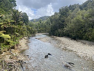
The Maraehara River is a river of the Gisborne Region in New Zealand. Rising on the eastern slopes of Mount Whakatiki in the Ruatoria Forest, the river flows eastwards. It flows into the Pacific Ocean, sharing a coastal lagoon with the larger Waiapu River.
The Paturau River is a river of the Tasman Region of New Zealand's South Island. One of the northernmost rivers in the South Island, it flows predominantly north from its sources in the Wakamarama Range to reach the Tasman Sea 20 kilometres west of Collingwood.
The Little Grey River, also known as the Māwheraiti is a river of the West Coast Region of New Zealand. It is a major tributary of the Grey River / Māwheranui which it joins at Ikamatua.
Mount Franklin is a peak in the Nelson Lakes National Park in the Tasman Region of New Zealand. It is the northernmost – and highest – of New Zealand's four Mounts Franklin, located 15 kilometres (9.3 mi) south of Lake Rotoroa. It is the highest peak in the Tasman Region, just two metres higher than the nearby Mount Travers.

The Clarke River in Westland District is the southernmost of three rivers thus-named in the South Island of New Zealand. It is a major tributary of the Haast River, flowing southwest from its source on the slopes of Mount Hooker before joining with the Landsborough River three kilometres before the waters of both flow into the Haast at the point where the latter river turns west towards its outflow into the Tasman Sea.
The Stanley River is a river of the Tasman Region of New Zealand's South Island. It flows southeast from its sources in the Douglas and Anatoki Ranges, reaching the Waingaro River 12 kilometres west of Upper Takaka.
The Rainy River is a river of the southern Tasman Region of New Zealand's South Island. It flows north from its sources 2 kilometres (1.2 mi) north of Saint Arnaud, reaching the Motupiko River 6 kilometres (3.7 mi) east of the Hope Saddle. The Motupiko River is a tributary of the Motueka River.
The Spey River is a river in the Southland Region of New Zealand. Its entire length lies within the Fiordland National Park. The Spey rises at the Mckenzie Pass and Murrell's Pass either side of Mt Horatio (1,380 metres, and the river flows in a northeasterly direction, emptying into the West Arm of Lake Manapouri adjacent to the intake of the Manapouri Power Station. The Dusky Track follows the Spey valley for much of the river's length.
The Spey River is a river in the Tasman Mountains in the northwest of the South Island of New Zealand. The river drains Lake Aorere near the Aorere Saddle, and is fed by numerous small streams draining the Gouland Range on the west and part of the Domett Range on the east. It flows north then east before joining the upper reaches of the Aorere River.
The Castle River is a river in the Marlborough Region of New Zealand. Rising just north of Shingle Peak, the river flows east then south until it meets the Awatere River.
The Cass River is an alpine river in the Canterbury region of the South Island of New Zealand. It rises in the Hall Range immediately below Rankin Pass, and also receives water from the nearby Huxley Glacier. After dropping 600 metres (2,000 ft) very rapidly the river flows south with braided channels along a flat-bottomed valley for 25 kilometres (16 mi). The Leibig Range and Gamack Range are to the west, and the Haszard Range to the east. The river flows into the west side of Lake Tekapo where it has built up a gravel delta.
The Fork River is a short river in the far south of the West Coast Region in New Zealand. As the name suggests, the river has two branches, with the longer South branch draining a plateau. The larger Spoon River lies a couple of kilometres to the north.
The Robinson River is a river in the West Coast Region of the South Island of New Zealand. It is a tributary of the Upper Grey River and much of the river lies within the Lake Sumner Conservation Park. Rising on the slopes of Mount Boscawen on the main divide about 12 kilometres (7.5 mi) south of the Lewis Pass, the river runs west-southwest along a straight, narrow valley before turning northwest to reach the Upper Grey.

The Ashburton River / Hakatere is a river in the Canterbury region of New Zealand, flowing across Mid Canterbury from the Southern Alps to the Pacific Ocean. The official name of the river was amended to become a dual name by the Ngāi Tahu Claims Settlement Act 1998. It has been identified as an Important Bird Area by BirdLife International because it supports breeding colonies of the endangered black-billed gull.
The Tiraumea River is a river of the Tasman Region of New Zealand's South Island. The river has its source on the slopes of Mount Hutton at the southern end of the Braeburn Range, and runs northwest from the Tiraumea Saddle. It reaches the Tutaki River 10 kilometres southeast of Murchison. The area is known for hunting.
The Tōtara River is a river of the northern West Coast Region of New Zealand's South Island. It rises near Mount Kelvin in the Paparoa Range and flows northwest to reach the Tasman Sea 10 kilometres south of Cape Foulwind. The Little Totara River joins the Tōtara just before it reaches the sea.
The Tōtara River is a river of the southern West Coast of New Zealand's South Island. Rising on the slopes of Bald Hill the river flows north then west to reach the Tasman Sea two kilometres north of Ross.
The Waikare River is a river in the Bay of Plenty Region of New Zealand' North Island. It flows north from its origins between the peaks of Matawhio and Papakai north of Lake Waikaremoana to reach the Whakatane River 25 kilometres (16 mi) east of Murupara.


