
Caving, also known as spelunking and potholing, is the recreational pastime of exploring wild cave systems. In contrast, speleology is the scientific study of caves and the cave environment.
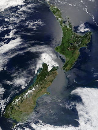
New Zealand is an island country located in the southwestern Pacific Ocean, near the centre of the water hemisphere. It consists of a large number of islands, estimated around 700, mainly remnants of a larger landmass now beneath the sea. The land masses by size are the South Island and the North Island, separated by the Cook Strait. The third-largest is Stewart Island / Rakiura, located 30 kilometres off the tip of the South Island across Foveaux Strait. Other islands are significantly smaller in area. The three largest islands stretch 1,600 kilometres across latitudes 35° to 47° south. New Zealand is the sixth-largest island country in the world, with a land size of 268,710 km2 (103,750 sq mi).

The Waikato River is the longest river in New Zealand, running for 425 kilometres (264 mi) through the North Island. It rises on the eastern slopes of Mount Ruapehu, joining the Tongariro River system and flowing through Lake Taupō, New Zealand's largest lake. It then drains Taupō at the lake's northeastern edge, creates the Huka Falls, and flows northwest through the Waikato Plains. It empties into the Tasman Sea south of Auckland, at Port Waikato. It gives its name to the Waikato region that surrounds the Waikato Plains. The present course of the river was largely formed about 17,000 years ago. Contributing factors were climate warming, forest being reestablished in the river headwaters and the deepening, rather than widening, of the existing river channel. The channel was gradually eroded as far up river as Piarere, leaving the old Hinuera channel through the Hinuera Gap high and dry. The remains of the old course are seen clearly at Hinuera, where the cliffs mark the ancient river edges. The Waikato's main tributary is the Waipā River, which converges with it at Ngāruawāhia.

The Department of Conservation is the public service department of New Zealand charged with the conservation of New Zealand's natural and historical heritage.

Tasman District is a local government district in the northwest of the South Island of New Zealand. It borders the Canterbury Region, West Coast Region, Marlborough Region and Nelson City. It is administered by the Tasman District Council, a unitary authority, which sits at Richmond, with community boards serving outlying communities in Motueka and Golden Bay / Mohua. The city of Nelson has its own unitary authority separate from Tasman District, and together they comprise a single region in some contexts, but not for local government functions or resource management (planning) functions.

Kahurangi National Park in the northwest of the South Island of New Zealand is the second largest of the thirteen national parks of New Zealand. It was gazetted in 1996 and covers 5,193 km2 (2,005 sq mi), ranging from the Buller River near Murchison in the south, to the base of Farewell Spit in Golden Bay in the north. The park has no single dominant landform, but includes an unusually wide variety of landscapes, including mountain ranges, rivers, gorges, raised peneplains and karst features such as caves and arches. Many of the landforms within the park are considered to be nationally or internationally significant.

Harwoods Hole is a cave system located in the northwest of the South Island of New Zealand, in the Abel Tasman National Park. At 183 metres (600 ft), it is New Zealand's deepest vertical shaft. It was first explored in 1958, long after it was discovered.

Paparoa National Park is on the west coast of the South Island of New Zealand.
Waitomo is a rural community in the King Country region of New Zealand's North Island. There are several solutional cave systems in the area around the village, which are popular tourist attractions. Restaurants and accommodation are centred in the village to serve visiting tourists.

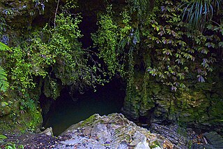
Nettlebed Cave is a limestone cave located in the Mount Arthur region of the northwest South Island of New Zealand. The presence of ongaonga, an endemic tree nettle, near the bottom entrance gives the cave its name.

Kelly Tarlton's Sea Life Aquarium is a public aquarium opened in 1985 in Auckland, New Zealand. Located at 23 Tamaki Drive, it was the brainchild of New Zealand marine archaeologist and diver Kelly Tarlton (1937–1985).
Marc Christopher Gwynne Ellis is a New Zealand businessman, television presenter, and former rugby union and rugby league footballer who played in the 1990s and 2000s. A graduate of the University of Otago, his primary business interest was in Charlie's, a juice company. During the 1995 Rugby World Cup he scored six tries in the game against Japan, which is the record for the most tries by an individual in a Rugby World Cup match.

The Oparara Basin Arches are a number of natural limestone tunnels formed by the Oparara River, in the Oparara Basin, New Zealand. The two most famous ones are the 'Oparara Arch', large enough for a multi-storey house, and the 'Moria Gate Arch', which is smaller in height.

The Paparoa Range is a mountain range in the West Coast region of New Zealand's South Island. It was the first New Zealand land seen by a European – Abel Tasman in 1642. Part of the range has the country's highest protection as a national park; the Paparoa National Park was established in 1987. Within that park, the Cave Creek disaster occurred in 1995.
Jarrod Michael Jablonski is a pioneering technical diver and record setting cave diver as well as an accomplished business owner and operator. These business operations include Halcyon Manufacturing, Extreme Exposure Adventure Center and Global Underwater Explorers. In July 2021 Jablonski launched and now operates the world's deepest pool at Deep Dive Dubai. Jablonski is one of the main architects behind the 'Doing It Right' system of diving.

Mount Arthur is in the Wharepapa / Arthur Range in the north western area of the South Island of New Zealand. Mount Arthur, named after Captain Arthur Wakefield, lies within Kahurangi National Park and has a peak elevation of 1,795 metres (5,889 ft).

Otorohanga railway station serves the town of Ōtorohanga, on the North Island Main Trunk in New Zealand. The current station dates from 1924.

Sistema Huautla is a cave system in the Sierra Mazateca mountains of the southern Mexican state of Oaxaca. As of April 2021 it was the deepest cave system in the Western Hemisphere, 1,560 metres (5,120 ft) from top to bottom, with over 55 miles of mapped passageways.
The Wharepapa / Arthur Range is a mountain range partially marking the boundary between the Tasman District and West Coast Region of New Zealand's South Island. The range is at the eastern extent of the Tasman Mountains which make up much of the island's northwest, making it easily visible from across the low-lying Waimea Plains further to the east. The range's location and its many uses make it a significant site for local Māori, including the iwi of Te Ātiawa and Ngāti Rārua. This includes the prominent peaks of Mount Arthur and Pukeone / Mount Campbell, which both hold mana in their own right and have become part of the identity of the aforementioned iwi.
