
Nelson Lakes National Park is in the South Island of New Zealand, at the northern end of the Southern Alps. It was created in 1956. The park contains beech forests, multiple lakes, snow-covered mountains and valleys created by glaciers during the ice ages.

The Kaikōura Ranges are two parallel ranges of mountains located in the Canterbury Region in the northeast of the South Island of New Zealand. The two ranges are visible from a great distance, including from the southern coast of the North Island.
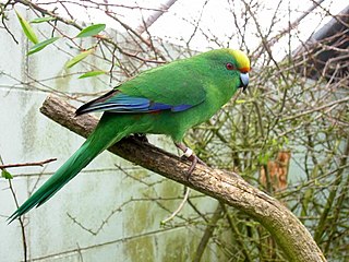
Malherbe's parakeet is a small parrot endemic to New Zealand, where it is known as the orange-fronted parakeet or orange-fronted kākāriki. In the rest of the world it is called Malherbe's parakeet, as when it was recognised as a species, the name "orange-fronted parakeet" was already used for Eupsittula canicularis, a Central American species. Restricted to a few valleys in the South Island and four offshore islands, its population declined to around 200 in the 1990s, and it is considered critically endangered by the IUCN.

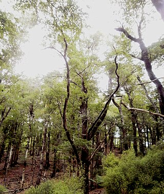
Nothofagus menziesii, commonly known as silver beech, is a tree of the southern beech family endemic to New Zealand. Its common name probably comes from the fact that its bark is whitish in colour, particularly in younger specimens. It is found from Thames southwards in the North Island, and throughout the South Island. Silver beech is a forest tree up to 30 m tall. The trunk, which is often buttressed, may be up to 2 m in diameter. The leaves are small, thick and almost round in shape, 6 to 15 mm long and 5 to 15 mm wide with rounded teeth which usually occur in pairs, 1 or 2 hair fringed domatia are found on the underside of each leaf. Its Māori name is tawhai. It grows from low altitudes to the mountains. Nothofagus menziesii was proposed to be renamed Lophozonia menziesii in 2013.
Nothofagus truncata, or hard beech, is a species of tree endemic to New Zealand. Its common name derives from the fact that the timber has a high silica content, making it tough and difficult to saw. Hard beech is a tree up to 30m tall occurring in lowland and lower montane forest from latitude 35°S to 42°30'S, that is, from the north of the North Island southwards to Marlborough and south Westland in the South Island. In Taranaki it forms almost pure stands on the rugged sandstone country there and is partially deciduous, dropping many of its leaves at the end of the winter. N. truncata became known as Fuscospora truncata after 2013 in New Zealand.

The environment of New Zealand is characterised by an endemic flora and fauna which has evolved in near isolation from the rest of the world. The main islands of New Zealand span two biomes, temperate and subtropical, complicated by large mountainous areas above the tree line. There are also numerous smaller islands which extend into the subantarctic. The prevailing weather systems bring significantly more rain to the west of the country. New Zealand's territorial waters cover a much larger area than its landmass and extend over the continental shelf and abyssal plateau in the South Pacific Ocean, Tasman Sea and Southern ocean.
Hamilton Ecological District is part of the Waikato Ecological Region in New Zealand's North Island. It occupies the Hamilton basin and surrounding foothills, and has been heavily modified with less than two percent of its indigenous vegetation remaining. This location has been studied significantly including the process of restoration ecology.

Phyllocladus alpinus, the mountain toatoa or mountain celery pine, is a species of conifer in the family Podocarpaceae. It is found only in New Zealand. The form of this plant ranges from a shrub to a small tree of up to seven metres in height. This species is found in both the North and South Islands. An example occurrence of P. alpinus is within the understory of beech/podocarp forests in the north part of South Island, New Zealand.

The Spenser Mountains is a topographic landform in the northern South Island of New Zealand. Located at the southern end of the Nelson Lakes National Park and north of the Lewis Pass they form a natural border between the Canterbury and Tasman regions. Several peaks are named after characters in Edmund Spenser’s allegorical poem, The Faerie Queene. Many of the early explorers were evidently literate men. For example, Frederick Weld named Lake Tennyson; William Travers named the Spensers and Faerie Queene; Julius Haast named Mt Una.

Raukaua simplex, or haumakāroa, is a species of evergreen plant in the Araliaceae family. This species is native to New Zealand. The species occurs in certain lowland, montane and subalpine forests from the Waihou River southward to Stewart Island and the Auckland Islands. An example occurrence in Westland forests includes associates such as Cyathea smithii and Dicksonia squarrosa.
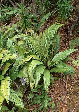
Austroblechnum durum, synonym Blechnum durum, is a species of fern in the family Blechnaceae. The fern is endemic to New Zealand.

Austroblechnum lanceolatum, synonym Blechnum chambersii, is a species of fern within the family Blechnaceae, found in Australia, New Zealand, Samoa and Fiji. It is indigenous to Australia and New Zealand.

Raukaua edgerleyi is a species of plant which is native to New Zealand. An example occurrence in Westland District podocarp/broadleaf forests includes flora associates such as Cyathea smithii, Dicksonia squarrosa and Blechnum discolor.

The Doubtful River is a river in the Canterbury region of New Zealand. It rises near Mount Barron and flows south then south-east through Lake Sumner Forest Park, reaching the Boyle River 40 kilometres (25 mi) west of Hanmer Springs. The Doubtful Range lies to the south. The Doubtless River and Devilskin Stream are tributaries entering from the north.
The Grantham River is a river in the Canterbury region of New Zealand. It arises in the Hanmer Range near Mount Miromiro, in the Hanmer Forest Park, and flows south-east into the Waiau Uwha River, which has its mouth on the Pacific Ocean.
The Montgomerie River is a river in the Buller District of New Zealand's South Island. It flows southwest from the Victoria Range to reach the Waitahu River 12 kilometres (7.5 mi) east of Reefton. The river's entire length is within Victoria Forest Park.

The Newton River is a river in Fiordland, New Zealand. It drains Lake Fraser south-westward into the Tasman Sea just south of West Cape.
The Upper Grey River is a river of the West Coast Region of New Zealand's South Island. As the name suggests, it is a stretch of the Grey River, and the name is used for the section between the confluence of the Blue Grey River, Brown Grey River, and Crooked Mary Creek in the Southern Alps and the Upper Grey's confluence with the Little Grey River 25 kilometres southwest of Reefton.

Nothofagus cliffortioides, commonly called mountain beech, is a species of Southern beech tree and is endemic to New Zealand. Mountain beech grows in mountainous regions at high elevations. In New Zealand the taxon is called Fuscospora cliffortioides. Nothofagus cliffortioides occupies a wider range of habitat than any other New Zealand tree species and it shows a corresponding range of life form, seeding habits, regenerative patterns, growth habits, growth rates, stand replacement and mortality patterns.
Peter Wardle was a New Zealand botanist.
