The Travers-Sabine Circuit is a popular tramping route in Nelson Lakes National Park, New Zealand. The full circuit takes about five to six days, although many side-trips are possible for longer tramps.
The circuit involves both bush-walking and alpine passes. In bush areas, the tracks are well marked. Routes in alpine areas are marked with poles.
In Summer and Autumn (December to April) the circuit is accessible to anyone reasonably fit. During Winter and Spring (May to November), snowfall, especially in Alpine areas, make the route more technical, and appropriate skills, equipment and experience are needed. Some parts of the track are subject to flooding during heavy rain.
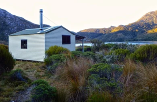
No permits are required to walk the route, but trampers should register at the National Park headquarters. Basic huts are available for overnight accommodation at regular intervals on the route, on a first-come, first-served basis. Fees are required for the huts, but there's no fee for the walk itself.
Typical itinerary
Day 1: From St. Arnaud, walk alongside Lake Rotoiti to Lake Head hut (2–3 hours). Continue up the Travers valley to John Tait Hut (about 5 hours from Lake Head).
Day 2: Continue up Travers Valley to Upper Travers Hut (3 hours)
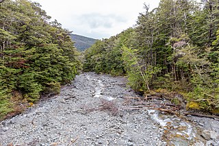
Day 4: Continue down the Sabine Valley to the head of Lake Rotoroa and Sabine Hut (5 hours).
Day 5: From Sabine Hut climb Mt. Cedric to Lake Angelus (5–6 hours).
Day 6: From Lake Angelus, proceed along the Robert Ridge to the Mt. Robert car park (6–7 hours). Hitch a ride or walk back to St. Arnaud (1–2 hours).
In this itinerary, days 2 and 4 are half-day walks, and days 3 and 5 are less than full day. Experienced trampers can easily complete the circuit in five days.
Also, an alternative to Days 5-6 is to return via Howard and Speargrass Valleys (quicker and easier in bad weather, but less interesting).
Shorter circuits
2 Days: Lake Rotoiti, Travers Valley, Hukere Stream to Lake Angelus (Day 1). Exit via the Robert Ridge (day 2).
3 Days: Lake Rotoiti, Travers Valley, Hopeless Creek Hut (Day 1). Ascend through Sunset Saddle to Lake Angelus (Day 2). Exit via Robert Ridge (Day 3).
Gallery
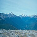
Lake Rotoiti from the start of the Travers-Sabine Circuit at Kerr Bay
In New Zealand, long distance walking or hiking for at least one overnight stay is known as tramping. There are a number of walkways in New Zealand, however most of these are relatively short and can be walked in a day or less. Many are also an easy walk, with well formed footpaths. However, some tracks require an overnight stay either because of the rugged country or the length of the track.
The Sabine River is in the South Island of New Zealand. It is located in Nelson Lakes National Park.
The Travers River is in the South Island of New Zealand.
Nelson Lakes National Park is in the South Island of New Zealand, at the northern end of the Southern Alps. It was created in 1956. The park contains beech forests, multiple lakes, snow-covered mountains and valleys created by glaciers during the ice ages.
Arthur's Pass National Park is located in the South Island of New Zealand and covers 1,185 km2 of mostly mountainous terrain. Adjacent to it lies Craigieburn Forest Park. The park is administered by the Department of Conservation.
The Routeburn Track is a world-renowned, 32 km tramping (hiking) track found in the South Island of New Zealand. The track can be done in either direction, starting on the Queenstown side of the Southern Alps, at the northern end of Lake Wakatipu or on the Te Anau side, at the Divide, several kilometres from the Homer Tunnel to Milford Sound.
The Milford Track is a hiking route in New Zealand, located amidst mountains and temperate rain forest in Fiordland National Park in the southwest of the South Island. The 53.5 km (33.2 mi) hike starts at Glade Wharf at the head of Lake Te Anau and finishes in Milford Sound at Sandfly Point, traversing rainforests, wetlands, and an alpine pass.
Saint Arnaud is a small alpine village in the Tasman district of New Zealand's South Island, west of the mountains of the Saint Arnaud Range and 90 kilometres southwest of Nelson near the historic Tophouse Settlement. It is situated at the northern end of Lake Rotoiti.
The Tongariro Alpine Crossing in Tongariro National Park is a tramping track in New Zealand, and is among the most popular day hikes in the country. The Tongariro National Park is a World Heritage site which has the distinction of dual status, as it has been acknowledged for both its natural and cultural significance.
The Kepler Track is a 60 km (37 mi) circular hiking track which travels through the landscape of the South Island of New Zealand and is situated near the town of Te Anau. The track passes through many landscapes of the Fiordland National Park such as rocky mountain ridges, tall mossy forests, lake shores, deep gorges, rare wetlands and rivers. Like the mountains it traverses, the track is named after Johannes Kepler. The track is one of the New Zealand Great Walks and is administered by the Department of Conservation (DOC).
The New Zealand Great Walks are a set of popular tramping tracks developed and maintained by the Department of Conservation. They are New Zealand's premier tracks, through areas of some of the best scenery in the country, ranging from coastlines with beaches to dense rain forests and alpine terrain. The tracks are maintained to a high standard, making it easier for visitors to explore some of the most scenic parts of New Zealand's backcountry.
Pourangahau / Mount Robert is a 1,421m high mountain in the Nelson area of New Zealand's South Island. It is within the Nelson Lakes National Park. For many years Mt Robert formed part of landowner and politician John Kerr of Nelson's Lake Station, but was returned to the crown in the years following his death in 1898. The partially unsealed Mt Robert Road, just west of the town of Saint Arnaud leads to a car park that is the start of tramping tracks into the Nelson Lakes National Park, and also a 5-hour loop walk up the mountain: The Pinchgut Track zigzags steeply up to near the top of Mt Robert, then continues along a ridge to Bushline Hut, before descending via the more gentle Paddy's Track. The track offers view over Lake Rotoiti and St Arnaud.
Lake Rotoiti, previously also known as Lake Arthur, is a lake in the Tasman Region of New Zealand. It is a substantial mountain lake within the borders of Nelson Lakes National Park. The lake is fed by the Travers River, water from the lake flows into the Buller River. The lake is surrounded by beech forest and is 82 metres (269 ft) deep. Saint Arnaud is a small community at the northern end of the lake.
Rotomairewhenua / Blue Lake is a small lake in Nelson Lakes National Park, in the northern reaches of New Zealand's Southern Alps. Sacred to local Māori, it has the clearest natural fresh water in the world.
Craigieburn Forest Park is a protected area in the South Island of New Zealand, adjacent to Arthur's Pass National Park to the north.
The Doubtful River is a river in the Canterbury region of New Zealand. It rises near Mount Barron and flows south then south-east through Lake Sumner Forest Park, reaching the Boyle River 40 kilometres (25 mi) west of Hanmer Springs. The Doubtful Range lies to the south. The Doubtless River and Devilskin Stream are tributaries entering from the north.
The Hinemoatū / Howard River is a river of the northern South Island of New Zealand. A tributary of the Buller River, the Hinemoatū/Howard starts at the confluence of the Hodgson and Tier Streams in the Travers Range of Nelson Lakes National Park, flowing north between Lakes Rotoroa and Rotoiti, before reaching the Buller between Kawatiri and Saint Arnaud. Close to its confluence with the Buller, the river is bridged by State Highway 63 and further up by Howard Valley Road.
Boulder Lake is a lake in the Tasman District of New Zealand located within Kahurangi National Park. In the late 1890s and early 1900s, water from the lake was used for gold mining purposes for which the lake level was raised by a low dam. British investors lost much money with the venture and large scale mining stopped in 1905 when a flood took out part of the flume. The dam was blown up in the 1930s by a farmer disgruntled with depression-era gold miners stealing his sheep. Boulder Lake is today a tramping destination, with the Department of Conservation maintaining both a hut at the lake and a track to the lake.
Maniniaro / Angelus Peak is a mountain in Nelson Lakes National Park, near the northwestern extent of New Zealand's main divide. Although it is not the tallest peak in the Angelus Ridge or the wider Travers Range, Maniniaro remains a popular tramping destination and is significant to the Ngāti Apa ki te Rā Tō iwi, who claim mana whenua within the area. According to Ngāti Apa ki te Rā Tō beliefs, the mountain is intrinsically linked with nearby Rotomaninitua / Lake Angelus, with the two both said to represent the footprints of the iwi's ancestors as they embarked on their journey back to Hawaiki. It is also near both major lakes of the national park, being roughly 6 kilometres (3.7 mi) from the southern ends of both Lakes Rotoiti and Rotoroa.
The historic Haast to Paringa Cattle Track is a trail through South Westland, New Zealand, constructed in 1875 to allow farmers in the Landsborough and Cascade Valley area to drive their cattle on an annual two-week journey to the sale yards in Whataroa. It was constructed as an inland loop to bypass the precipitous cliffs at Knights Point. For 90 years it was the only land access to the settlements of Haast and Jackson Bay, but the last mob of cattle was driven in 1961, and the construction of a highway connecting Paringa to Haast Pass in 1965 made it redundant. After falling into disuse, the cattle track was converted into a 33-kilometre (21 mi), three-day tramping track, opening in 1981. The track and its three huts are maintained by the New Zealand Department of Conservation.
This page is based on this Wikipedia article Text is available under the CC BY-SA 4.0 license; additional terms may apply. Images, videos and audio are available under their respective licenses.