Related Research Articles

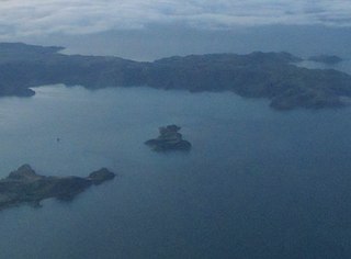
Lake Rotoroa lies within the borders of Nelson Lakes National Park in the South Island, New Zealand. The lake is fed by the D'Urville and Sabine rivers.

Nelson Lakes National Park is in the South Island of New Zealand, at the northern end of the Southern Alps. It was created in 1956. The park contains beech forests, multiple lakes, snow-covered mountains and valleys created by glaciers during the ice ages.
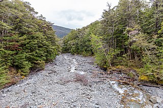
Te Kauparenui / Gowan River is in the South Island of New Zealand. Its source is at Lake Rotoroa and travels 11 kilometres before feeding into the Buller River. Mixed farming and forestry occurs on both banks of the river. The river has introduced trout which attracts recreational fishing.

Bulmer Cavern is New Zealand's longest cave system, running for 74.3 km (46.2 mi) through Mount Owen in the Tasman region of the northwest South Island. John Patterson discovered the cave on New Year's Day 1984, by dropping a rock down and counting the seconds until it reached the bottom.

The Buller Gorge is a gorge located in the northwest of the South Island of New Zealand. The Buller River flows through the deep canyon between Murchison and Westport. Land Information New Zealand lists two sections for the gorge, Upper Buller Gorge and Lower Buller Gorge. State Highway 6 runs alongside, but considerably above, the river through the gorge. The Stillwater - Westport Line railway also runs through the gorge.

Rotoroa Island is an island to the east of Waiheke Island in the Hauraki Gulf of New Zealand. It covers 82 hectares. The Salvation Army purchased it for £400 in 1908 from the Ruthe family to expand their alcohol and drug rehabilitation facility at nearby Pakatoa Island. Men were treated at Home Bay at Rotoroa, while women were treated at Pakatoa. This treatment facility was closed in 2005.
Pakatoa Island, previously known as Bell's Island is one of many islands in the Hauraki Gulf of New Zealand, covering 24 hectares. Purchased in the early 1900s by the Salvation Army it was used as an alcohol treatment centre for men for two years, and later women when a larger facility was constructed on Rotoroa Island.

The Saint Arnaud Range is a mountain range in the central north of New Zealand's South Island. It lies between Lake Rotoiti and the upper reaches of the Wairau River, and marks the eastern boundary of Nelson Lakes National Park.
The Glasgow Range is a mountain range on the northern West Coast of New Zealand's South Island. It is north of the Papahaua Range and its most significant river is the Mōkihinui River.
Lake Rotoroa may refer to the following New Zealand lakes:

The Travers-Sabine Circuit is a popular tramping route in Nelson Lakes National Park, New Zealand. The full circuit takes about five to six days, although many side-trips are possible for longer tramps.
The Hinemoatū / Howard River is a river of the northern South Island of New Zealand. A tributary of the Buller River, the Hinemoatū/Howard starts at the confluence of the Hodgson and Tier Streams in the Travers Range of Nelson Lakes National Park, flowing north between Lakes Rotoroa and Rotoiti, before reaching the Buller between Kawatiri and Saint Arnaud. Close to its confluence with the Buller, the river is bridged by State Highway 63 and further up by Howard Valley Road.
The Tutaki River is a river of the Tasman Region of New Zealand's South Island. It flows north from its sources southwest of Lake Rotoroa to reach the Mangles River 10 kilometres east of Murchison.
Lake Rotokawau is a dune lake on the Aupōuri Peninsula the Far North, New Zealand. The name is also used for lakes in the Kaipara District, Chatham Islands, in Bay of Plenty and near Lake Waikare in Waikato.
Lake Rotoroa is a dune lake in the Northland Region of New Zealand. It is located to the west of Awanui.
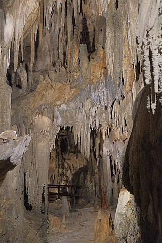
The Ngārua Caves are a series of limestone caves in the Takaka Hill range south of Abel Tasman National Park.
Woodstock is a small settlement in the Tasman District of the northern South Island of New Zealand. It is located on the Motueka Valley Highway, close to the eastern bank of the Motueka River, some 20 kilometres southwest of Motueka, at the junction of the Motueka River and its small tributary, the Dove River.
Lake Heather (Wai Te Huahua) is a dune lake in the Far North District of New Zealand. It is located west of the town of Awanui, and between the larger Lake Ngatu and Lake Rotoroa.
Dovedale is a settlement in the Tasman District of New Zealand's upper South Island.

The Big Rimu Walk is a nature trail near Karamea, located in Kahurangi National Park on the West Coast of the South Island of New Zealand. A short walk of 1.1 kilometres (0.68 mi) through regenerating bush leads to a large rimu tree that is 36 metres (118 ft) tall with a trunk over two metres in diameter and estimated to be over 1,000 years old. Other smaller rimu in the area were logged during the 1940s but this large tree was left.
References
- ↑ "Place name detail: Rotoroa". New Zealand Gazetteer. New Zealand Geographic Board . Retrieved 17 March 2018.
41°47′44″S172°35′35″E / 41.7955°S 172.593°E
| | This Tasman District geography article is a stub. You can help Wikipedia by expanding it. |