
The Clearwater River is on the West Coast of the South Island of New Zealand. The river originates on the northern slopes of Mount Mitchell on the western end of the Victoria Range, only one valley north of the Fox Glacier and Fox River. Clearwater River and its tributary creeks drain land to the north of the Cook River / Weheka. The river flows under a bridge of SH 6 just north of the Fox Glacier township and passes close to Lake Matheson shortly after before flowing into Cook River / Weheka, which drains into the Tasman Sea.

Moturoa / Rabbit Island is a small island that lies across the southernmost part of Tasman Bay / Te Tai-o-Aorere, on the northern coast of New Zealand's South Island. The long narrow island runs east–west for 8 kilometres (5 mi), and covers 15 km2 (5.8 sq mi).

The Paparoa Range is a mountain range in the West Coast region of New Zealand's South Island. It was the first New Zealand land seen by a European – Abel Tasman in 1642. Part of the range has the country's highest protection as a national park; the Paparoa National Park was established in 1987. Within that park, the Cave Creek disaster occurred in 1995.
The Awaroa River is a short river in the Far North District of New Zealand. It is 25 kilometres (16 mi) south of Kaitaia, and flows southwest for 12 kilometres (7.5 mi), reaching the Tasman Sea to the north of the Hokianga Harbour. Its estuary forms one of the two arms of Whangape Harbour.
The Kumengamatea River is a river of the Northland Region of New Zealand's North Island. It flows southwest into the Awaroa River close to the latter's outflow into the Wairoa River.
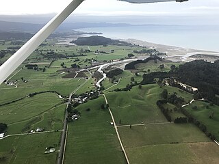
The Motupipi River is a short river of the Tasman Region of the South Island of New Zealand. Located in the Tākaka valley in Golden Bay, it used to be the most polluted river in the Tasman Region. Significant stream regeneration work has been underway since the early 2000s.
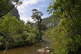
The Pororari River, with an older spelling of Porarari, is a river of the West Coast Region of New Zealand's South Island. It flows northwest from its sources in the Paparoa Range, reaching the Tasman Sea at Punakaiki via Pororari Lagoon. Cave Creek / Kotihotiho is a tributary to the river. There are opportunities to tramp along this river, with two different options accommodating multi-hour loop walks. Further upstream, the Pororari River is followed by the new Paparoa Track, which provides an opportunity for multi-day tramping or mountain biking.
The Rolling River is a short river of the Tasman Region of New Zealand's South Island. It is formed by the confluence of several streams - Nuggety Creek, Blue Creek, and Granity Creek - and flows north to reach the Wangapeka River 12 kilometres north of Mount Owen.
The Rotokakahi River is a river of the Northland Region of New Zealand's North Island. Its winding course is predominantly southwestward from its origins in the Maungataniwha Range. It reaches the Tasman Sea 25 kilometres (16 mi) south of Kaitaia, and its estuary forms one of the two arms of Whangape Harbour.

The Waiho River is a river of the West Coast region of New Zealand's South Island. It is fed by the meltwater of the Franz Josef Glacier and skirts the main township of Franz Josef to its south, where its river bed is crossed by SH 6 on a long single-lane bridge. Due to changes in rainfall and snow melt, the river's water flow varies greatly. In a severe rain storm on 26 March 2019, the bridge was destroyed after 400 millimetres (16 in) of rain had fallen. The bridge and one abutment was rebuilt, and the road link reopened after 18 days. The works cost NZ$6m.

The Waikūkūpa River is a river of the West Coast region of New Zealand's South Island. It flows northwest through Westland Tai Poutini National Park to reach the Tasman Sea 14 kilometres north of Fox Glacier township.

The Waitangitāhuna River are two rivers in the West Coast region of New Zealand's South Island. It was a single river until an avulsion in March 1967, when it became two rivers. Since then, the southern portion of the river has flowed into Lake Wahapo, while the northern section discharges into the Tasman Sea north of Ōkārito Lagoon.
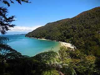
Tinline Bay is a cove and beach located within The Abel Tasman National Park in the South Island of New Zealand.

The Lewis River is a tributary of the Heaphy River in New Zealand's Kahurangi National Park.

The Butler Range, also known as North Butler Range, is a range located in the Westland District of the West Coast Region on the South Island of New Zealand. The range has also been known as Peaks of the Mist Range.

The Waitakere / Nile River is a river on the West Coast of New Zealand's South Island. It rises in the Paparoa Range and flows through a limestome karst landscape in a roughly northwest direction for its entire length, reaching the Tasman Sea just north of Charleston. The river and its surrounds are a popular tourist destination, particularly for a bush train along the river's canyon and caving through the nearby Metro / Te Ananui Caves. The lower reaches of the river are also a popular fishing spot, particularly for brown trout.

Ship Creek is a small river that flows into an area of coastal swamp forest on the West Coast of New Zealand's South Island. Ship Creek is approximately 11 km (6.8 mi) long and flows northwest from catchment areas on the slopes of Bald Hill, reaching the Tasman Sea around 20 km (12 mi) north-east of Haast. Near the mouth of Ship Creek, there are short walks around dune lakes and ancient kahikatea swamp forest.

The Awapoto River, also known as Little River as a literal translation from Māori, is a river in the Tasman District of New Zealand. It rises east of Evans Ridge. There are no named peaks near the source, but the Abel Tasman Inland Track follows Evans Ridge near the river's source. The Awapoto River initially flows north-east and then east through the Abel Tasman National Park. It flows through Hadfield Clearing and then passes under Awaroa Road before entering the Awaroa Inlet.

Awaroa Inlet is a remote, alluring body of water within the Abel Tasman National Park, at the northern end of Tasman Bay, in the Tasman Region of the South Island, New Zealand.
Awaroa River is an unofficial name for a stream in Kaipara, New Zealand.


