
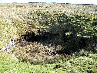
Harwoods Hole is a cave system located in the northwest of the South Island of New Zealand, in the Abel Tasman National Park. At 183 metres (600 ft), it is New Zealand's deepest vertical shaft. It was first explored in 1958, long after it was discovered.
Krubera Cave is the second-deepest-known cave on Earth, after the Veryovkina Cave. It is located in the Arabika Massif of the Gagra Range of the Western Caucasus, in the Gagra District of Abkhazia, a partly recognised state, previously part of Soviet Georgia.

Gouffre Jean-Bernard or Réseau Jean Bernard, sometimes known simply as Jean Bernard, is the seventh deepest cave in the world, and the third deepest one in Europe. It is in the Alps in Samoëns, France. The first entrance to the cave was found by the French caving group Groupe Vulcain in 1963. More entrances have been found over the years since, and currently at least thirteen are known. The highest entrance, known as C37, is at 2,333 m (7,654 ft) above sea level. The cave is named after Jean Dupont and Bernard Raffy, two Groupe Vulcain members who died in 1963 in an unrelated expedition in Goule de Foussoubie Cave.

The Marble Arch Caves are a series of natural limestone caves located near the village of Florencecourt in County Fermanagh, Northern Ireland. The caves are named after the nearby Marble Arch, a natural limestone arch at the upstream end of Cladagh Glen under which the Cladagh River flows. The caves are formed from three rivers draining off the northern slopes of Cuilcagh mountain, which combine underground to form the Cladagh. On the surface, the river emerges from the largest karst resurgence in Ireland, and one of the largest in the United Kingdom. At 11.5 kilometres (7.1 mi) the Marble Arch Caves form the longest known cave system in Northern Ireland, and the karst is considered to be among the finest in the British Isles.
Langcliffe Pot is a cave system on the slopes of Great Whernside in Upper Wharfedale, about 3 kilometres (1.9 mi) SSE of Kettlewell in North Yorkshire. It is part of the Black Keld Site of Special Scientific Interest where the "underground drainage system which feeds the stream resurgence at Black Keld is one of the largest and deepest in Britain, although only a small proportion of its cave passages are accessible at present." Mossdale Caverns is also part of the Black Keld SSSI. Although a considerable length of passage has been explored in Langcliffe Pot, the current end is over 170 metres (560 ft) above the resurgence, and over 4 kilometres (2.5 mi) in distance. A trip to the far end has been described as "one of the most serious undertakings in British caving".
Noon's Hole lies about 5 km northwest of the centre of Boho, in the townland of Old Barr in the parish of Devenish, County Fermanagh, close to the border with Boho parish. The cave is under part of the escarpment on the east side of the Glenade Sandstone uplands. At 81 m (266 ft), this pothole was thought to have the deepest shaft in Ireland, but this honour was passed to the nearby Reyfad Pot, which contains an entrance shaft of 88 m (289 ft). The continuation of the cave system contains 3.7 km (2.3 mi) of passage, and it connects to the resurgence at Arch Cave through three cave dives, making this system the 8th deepest in Ireland, at 108 m (354 ft).
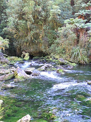
The Pearse River is a river of the Tasman Region of New Zealand's South Island. It flows east from sources in the Wharepapa / Arthur Range, reaching the Motueka River 20 kilometres southwest of Motueka.
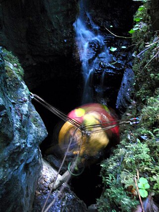
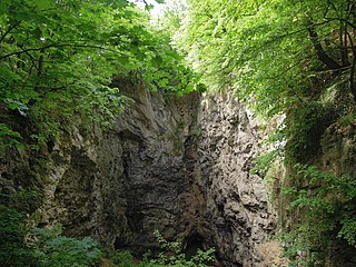
The Ellis Basin cave system is a group of interconnecting limestone caves located in the Mount Arthur region of the northwest South Island of New Zealand.
Sistema Cheve is a deep cave located in the Sierra Juárez mountain range in the southern Mexico state of Oaxaca. As of June 2023, its deepest point has been measured at 1,529 metres (5,016 ft) deep, This makes it the second deepest known cavern in Mexico and the Americas, as well as the world's 11th deepest cave. More than 55 miles (89 km) of passageways have been mapped within the cave.
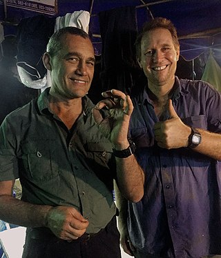
Craig Challen, SC is an Australian technical diver and cave explorer who played a substantial role in the Tham Luang cave rescue. He was the recipient of the Oztek 2009 Diver of the Year award for his services to caving, and was joint winner of the 2019 Australian of the Year.
Hranice Abyss is the deepest flooded pit cave in the world. It is a karst sinkhole near the town of Hranice, Czech Republic. The greatest confirmed depth is 519.5 m (1,704 ft), of which 450 m (1,476 ft) is underwater. In 2020, a scientific expedition to the cave revealed that part of the system apparently reaches 1 kilometre deep, albeit with the lowest reaches sediment-filled. Analysis of the water found carbon and helium isotopes which implied that the cave has been formed by acidic waters, heated by the mantle, welling up from below.
Pollatoomary is the deepest explored underwater cave in Ireland. It has been explored to an underwater depth of 113 metres (371 ft). The explored limit of Pollatoomary is also 23 metres (75 ft) deeper underwater than that of the terminal sump in Wookey Hole Caves in Somerset, England, which previously held the record for the deepest underwater cave in Great Britain and Ireland.

Short Drop Cave and Gavel Pot are different entrances into the same cave system on Leck Fell, in Lancashire, England. The main top entrance, Short Drop Cave, is a small hole in a fenced off shakehole near the main stream sink. Gavel Pot, a window into the system, is a large fenced shakehole some 40-metre (130 ft) deep requiring tackle to descend. There are two other smaller entrances into Short Drop Cave. At its base the system links via a sump with Lost Johns' Cave, and is part of the Three Counties System, an 87 kilometres (54 mi) cave system which spans the borders of Cumbria, Lancashire, and North Yorkshire.

Sistema Huautla is a cave system in the Sierra Mazateca mountains of the southern Mexican state of Oaxaca. As of April 2021 it is the deepest cave system in the Western Hemisphere, 1,560 metres (5,120 ft) from top to bottom, with over 55 miles of mapped passageways. It is the tenth deepest cave in the world. It is also the 26th longest cave system with over 100 km length.

Veryovkina Cave is a cave in Abkhazia, internationally recognized as part of Georgia. At 2,209 meters (7,247 ft) deep, it is the deepest-known cave on Earth. Veryovkina is in the Arabika Massif, in the Gagra mountain range of the Western Caucasus, on the pass between the Krepost and Zont mountains, close to the slopes of Mount Krepost. Its entrance is 2,285 meters (7,497 ft) above sea level. The entrance of the cave has a cross section of 3 m × 4 m, and the depth of the entrance shaft is 32 m (105 ft). The confirmed depth of the cave is 2,209 m (7,247 ft).

The Long Kin East Cave - Rift Pot system is a limestone cave system on the southern flanks of Ingleborough, North Yorkshire in England lying within the designated Ingleborough Site of Special Scientific Interest. Long Kin East Cave starts as a long meandering stream passage but then plummets down a 58-metre (190 ft) deep shaft when it meets a shattered fault into which Rift Pot also descends. At the bottom, the stream flows through some low canals and sumps, to eventually emerge at Austwick Beck Head in Crummackdale.
Bisaro Anima is a cave located on the Mount Bisaro plateau in British Columbia, Canada. It is the deepest cave in Canada.

Cave diving is underwater diving in water-filled caves. The equipment used varies depending on the circumstances, and ranges from breath hold to surface supplied, but almost all cave diving is done using scuba equipment, often in specialised configurations with redundancies such as sidemount or backmounted twinset. Recreational cave diving is generally considered to be a type of technical diving due to the lack of a free surface during large parts of the dive, and often involves planned decompression stops. A distinction is made by recreational diver training agencies between cave diving and cavern diving, where cavern diving is deemed to be diving in those parts of a cave where the exit to open water can be seen by natural light. An arbitrary distance limit to the open water surface may also be specified. Despite the risks, water-filled caves attract scuba divers, cavers, and speleologists due to their often unexplored nature, and present divers with a technical diving challenge.
The Wharepapa / Arthur Range is a mountain range partially marking the boundary between the Tasman District and West Coast Region of New Zealand's South Island. The range is at the eastern extent of the Tasman Mountains which make up much of the island's northwest, making it easily visible from across the low-lying Waimea Plains further to the east. The range's location and its many uses make it a significant site for local Māori, including the iwi of Te Ātiawa and Ngāti Rārua. This includes the prominent peaks of Mount Arthur and Pukeone / Mount Campbell, which both hold mana in their own right and have become part of the identity of the aforementioned iwi.

The Réseau du Clot d'Aspres is a cave system located mainly under the valley of Clot d'Aspres, which lies within the commune of Villard-de-Lans in the north of the Vercors Massif, in Isère, France. This extensive karst system contains 42 kilometres (26 mi) of passages over a height range of 1,066 meters. The highest point is upstream of the Oréade cave +74 metres (243 ft), and the lowest point is the siphon of the Nuits-Blanches scialet which has been dived to a depth of 34 metres (112 ft).


