
Karamea is a town on the West Coast of the South Island of New Zealand. It is the northernmost settlement of any real size on the West Coast, and is located 96 kilometres (60 mi) northeast by road from Westport. Apart from a narrow coastal strip, the town of Karamea and its local area are completely surrounded to the south, east and north by Kahurangi National Park.
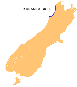
The Karamea Bight is the name given to a large bay in the Tasman Sea formed by a curved stretch of the West Coast of New Zealand's South Island. It stretches for 100 kilometres north from Cape Foulwind to just north of the mouth of the Heaphy River.

Arapito is a town in the Karamea area of New Zealand. Arapito is a farming community on the south side of the Karamea River, upriver from the main Karamea township.
State Highway 67 (SH 67) is a New Zealand state highway located in the northern parts of the South Island of New Zealand. It is 51.2 km long usually on the coast and connects SH 6 with the settlement of Mokihinui. It used to be 96 kilometres long and ran the entire length of the road from Westport to Karamea The highway and its spur serves the large West Coast town of Westport and lies entirely within the Buller District.
The Baton River is a river in the Tasman District of the South Island of New Zealand. It rises near the Baton Saddle in the Arthur Range and flows ESE then northeast before feeding into the Motueka River 2 kilometres (1.2 mi) south of Woodstock. A tramping track follows the upper part of the river valley, leading to the Karamea-Leslie track and Kahurangi National Park.

The Heaphy River is a river of the northwestern South Island of New Zealand. It flows through Kahurangi National Park, rising on the northern slopes of Amohia Peak and initially flowing northwest before turning southwest to reach the Tasman Sea 30 kilometres north of Karamea. Stages of the Heaphy Track follow the lower course of this river, with the track reaching the coast at the river's mouth. The Heaphy River is located in the Buller District.
The Kākāpō River is a river of New Zealand. It is located in the West Coast Region of the South Island. The river flows northwest from its source three kilometres west of Mount Kendall, reaching its outflow into the Karamea River 15 kilometres from the latter's mouth.

The Karamea River is located in the West Coast Region of the South Island of New Zealand. The river rises within Kahurangi National Park in the Matiri Range of the Southern Alps. The river rises to the east of Mount Allen, meandering west briefly before turning north. After some 25 km (16 mi) it again turns west, to enter a series of small lakes where its waters are joined by those of the Roaring Lion River. From here the river continues west through steep-sided valleys before leaving the national park and reaching its floodplain 10 km (6.2 mi) from the coast of the Tasman Sea. The river passes the small settlements of Umere and Arapito before reaching the Ōtūmahana Estuary and the Tasman Sea close to the township of Karamea.
The Leslie River is a river of the northwest of New Zealand's South Island located in the Buller District. A tributary of the Karamea River, the Leslie flows west from the Wharepapa / Arthur Range, meeting the Karamea 28 kilometres (17 mi) east of the town of Karamea. The river's entire length is within Kahurangi National Park.

The Little Wanganui River is a river of the West Coast Region of New Zealand's South Island. It flows generally west from the slopes of Mount Allen, reaching the Karamea Bight close to the small settlement of Little Wanganui. It is home to a large number of trout.
The Postal River is a river of the West Coast Region of New Zealand's South Island. It flows west from the Fenian Range, reaching the Ōpārara River five kilometres northeast of Karamea. The Postal River's entire length is within Kahurangi National Park.
The Roaring Lion River is a river in the Buller District of New Zealand's South Island located in Kahurangi National Park. It flows southeast from its source in the Tasman Mountains to the east of Mount Domett, gradually turning southwest before reaching the Karamea River 25 kilometres (16 mi) east of Karamea.
The Ugly River is a river of the West Coast Region of New Zealand's South Island. It flows south to reach the Karamea River 17 kilometres northeast of Karamea. The river's entire length is within Kahurangi National Park.

The Wangapeka River is a river of the Tasman Region of New Zealand's South Island. It rises in two branches, the North Branch and the South Branch, in the Matiri Range within Kahurangi National Park, meeting some 25 kilometres southeast of Karamea. It flows generally northeast to reach the Motueka River 30 kilometres south of Motueka.
The Crow River is a river located in Kahurangi National Park in the West Coast Region of New Zealand. It arises in the Wharepapa / Arthur Range and flows south-west and then north-west into the Karamea River. The river may be named after the South Island kōkako, sometimes called the orange-wattled crow.
The Taipō River is a river of the northern West Coast Region of New Zealand's South Island. It flows east from its sources at Mount Zetland, fed by many streams draining the north side of the Allen Range to reach the Karamea River 25 kilometres southeast of Karamea.
Little Wanganui is a dairy-farming village on the West Coast of the South Island of New Zealand, on the Little Wanganui River. It is 77 kilometres (48 mi) north of Westport and 21 kilometres (13 mi) south of Karamea, at the opposite end of the Karamea Beach. The settlement has a pub, community hall, and volunteer fire brigade, and in 2013 the population was 207. There is a surfing beach, and the Little Wanganui River is popular for whitebaiting and fishing for brown trout.

The Karamea Aerodrome serves the town of Karamea, in the South Island of New Zealand. It is a non certificated aerodrome located around 1.4 kilometres (0.87 mi) northwest of the town.

Ōtūmahana Estuary, also known as the Karamea Estuary, is a tidal estuary in the Buller District of the West Coast Region of New Zealand. It is located at the mouth of the Karamea River and also receives the outflow of Ōtūmahana creek.

The Wangapeka Track is a tramping track in the north-west of the South Island of New Zealand. It is one of the main tramping tracks in the Kahurangi National Park, a protected area managed by the Department of Conservation. The route traverses the southern end of the park, from the historic Wangapeka goldfields area west of Tapawera, to the coastal plains of the West Coast at Little Wanganui. The route is 59 km (37 mi) long, and crosses the Wangapeka and Little Wanganui saddles, each over 1,000 m (3,300 ft) in elevation. The track passes through the valleys of the Wangapeka River, Karamea River, Taipō River and Little Wanganui River. The majority of the track is in river valleys and under forest cover, with small sections in tussock land at Stag Flat and the Little Wanganui Saddle. It typically takes walkers 4–6 days to complete the route.


