
The Ahaura River is in the South Island of New Zealand. This river drains the western flanks of the Southern Alps and flows into the Grey River.
The Mākākahi River runs through the Manawatū-Whanganui region of the North Island of New Zealand.
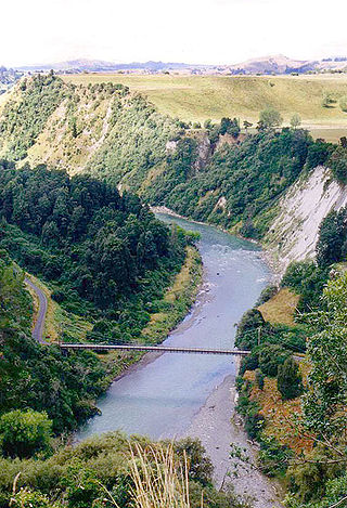
The Rangitīkei River is one of New Zealand's longest rivers, 253 kilometres (157 mi) long.
The Waihemo / Shag River is located in Otago in the South Island of New Zealand. It rises in the Kakanui Range, flowing southeast for 75 km (47 mi), or 50 kilometres (31 mi) before reaching the Pacific Ocean on the south side of Shag Point / Matakaea, 7.5 km (4.7 mi) east of Palmerston. The Dunback Branch railway that operated from the 1880s to 1989 largely followed the route of the river from its junction with the Main South Line near Shag Point township to its terminus in Dunback.

The Eglinton River is located in the region of Southland in the southwest of New Zealand. It flows through Fiordland National Park for 50 kilometres (31 mi). Its headwaters are at Lake Gunn, 25 kilometres (16 mi) east of Milford Sound, and it flows generally south before entering Lake Te Anau along the lake's eastern shore opposite the entrance to North Fiord.
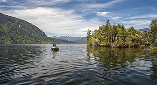
Lake Brunner is the largest lake in the West Coast Region of New Zealand, located 31 km (19 mi) southeast of Greymouth. The main settlement, Moana, is on its northern shore. It is an important settlement and waystation for local Māori. The first Europeans in the area were loggers, and sawmills were an important early industry. Being several kilometres inland from the coast road, it is less frequently visited by tourists than many of the West Coast's scenic highlights, but it is becoming increasingly popular, in part due to its reputation for fishing.
The Waihou River is located in the northern North Island of New Zealand. Its former name, Thames River, was bestowed by Captain James Cook in November 1769, when he explored 14 mi (23 km) of the river from the mouth. An older Māori name was "Wai Kahou Rounga". A 1947 Geographic Board enquiry ruled that the official name would be Waihou.

The Whanganui River is a major river in the North Island of New Zealand. It is the country's third-longest river, and has special status owing to its importance to the region's Māori people. In March 2017 it became the world's second natural resource to be given its own legal identity, with the rights, duties and liabilities of a legal person. The Whanganui Treaty settlement brought the longest-running litigation in New Zealand history to an end.

The Whakapapa River in New Zealand forms from streams which trickle off the Whakapapa skifield of Mount Ruapehu and down the western slopes of the mountain. The river passes near Ōwhango, before finally merging with the Whanganui River just east of Kakahi, about 40 km (25 mi) from where it starts, which is in a 100 m (330 ft) deep gorge, at the confluence of the Whakapapaiti and Whakapapanui Streams.

Lake Ianthe is a lake located on the West Coast of New Zealand's South Island. A number of small streams flow into the lake and it empties into the Wanganui River. It is close to the coast and near the rural settlements of Pukekura and Hari Hari, and State Highway 6 runs along the eastern shore of the lake on its route between Ross and the Franz Josef Glacier.
Poerua River is a river in Westland District in the West Coast region of New Zealand's South Island. It flows from its headwaters in the Southern Alps to the Tasman Sea near Harihari. The river is a trout and salmon fishing location and its mouth is where it is met by the Hinatua River and is located roughly a kilometre south of the Wanganui River's mouth. On the morning of 6 October 1999, a landslide from Mount Adams blocked the Poerua River, creating a landslide dam about 11 km upstream from the State Highway 6 bridge over the river. Despite fears of flooding and other damage, there were relatively minimal impacts when the dam was breached six days later, though significant quantities of coarse gravel were deposited downstream and the river's course was changed in places.

The Hautapu River is a river in the Manawatū-Whanganui region of New Zealand. It originates east of the Ngamatea Swamp in the New Zealand Army's Waiouru Training area. From here it flows south, through private farmland, and in some places following State Highway 1, for several kilometres before entering the Rangitīkei River south of Taihape.

The Pohangina River is a river of the southwestern North Island of New Zealand. A tributary of the Manawatu River, it flows generally southward from its source in the Ruahine Range, through Pohangina, joining the Manawatu River about 15 kilometres (9 mi) northeast of Palmerston North at Ashhurst.
The Hapuka River is a river of Westland District, New Zealand. It flows from near The Woolsack north-west to join the Okuru and Turnbull Rivers just before they enter the Tasman Sea. The river is slow-moving and drains swampy land. There are brown trout in the lagoon area.
The Wakapuaka River is a river of the Nelson Region of New Zealand's South Island. It flows generally north from its origins in the north of the Bryant Range 14 kilometres (8.7 mi) east of Nelson city centre to reach Delaware Bay, an indentation in the northeast coast of Tasman Bay / Te Tai-o-Aorere.
The Dove River is a river in the Tasman Region of New Zealand. It arises in hills between the Wai-iti River and Motueka River and flows north-west into the Motueka near the locality of Woodstock. The river is named for the native New Zealand pigeons once found in the forests around the river.

Little Wanganui is a dairy-farming village on the West Coast of the South Island of New Zealand, on the Little Wanganui River. It is 77 kilometres (48 mi) north of Westport and 21 kilometres (13 mi) south of Karamea, at the opposite end of the Karamea Beach. The settlement has a pub, community hall, and volunteer fire brigade, and in 2013 the population was 207. There is a surfing beach, and the Little Wanganui River is popular for whitebaiting and fishing for brown trout.

A fishing license (US), fishing licence (UK), or fishing permit is an administrative or legal mechanism employed by state and local governments to regulate fishing activities within their administrative areas. Licensing is one type of fisheries management commonly used in Western countries, and may be required for either commercial or recreational fishing.

The Waitakere / Nile River is a river on the West Coast of New Zealand's South Island. It rises in the Paparoa Range and flows through a limestone karst landscape in a roughly northwest direction for its entire length, reaching the Tasman Sea just north of Charleston. The river and its surrounds are a popular tourist destination, particularly for a bush train along the river's canyon and caving through the nearby Metro / Te Ananui Caves. The lower reaches of the river are also a popular fishing spot, particularly for brown trout.

The Wangapeka Track is a tramping track in the north-west of the South Island of New Zealand. It is one of the main tramping tracks in the Kahurangi National Park, a protected area managed by the Department of Conservation. The route traverses the southern end of the park, from the historic Wangapeka goldfields area west of Tapawera, to the coastal plains of the West Coast at Little Wanganui. The route is 59 km (37 mi) long, and crosses the Wangapeka and Little Wanganui saddles, each over 1,000 m (3,300 ft) in elevation. The track passes through the valleys of the Wangapeka River, Karamea River, Taipō River and Little Wanganui River. The majority of the track is in river valleys and under forest cover, with small sections in tussock land at Stag Flat and the Little Wanganui Saddle. It typically takes walkers 4–6 days to complete the route.


