
The Hutt River flows through the southern North Island of New Zealand. It flows south-west from the southern Tararua Range for 56 kilometres (35 mi), forming a number of fertile floodplains, including Kaitoke, central Upper Hutt and Lower Hutt.

Charles Heaphy VC was an English-born New Zealand explorer and recipient of the Victoria Cross (VC), the highest military award for gallantry "in the face of the enemy" that could be awarded to British and Empire forces at the time. He was the first soldier of the New Zealand armed forces to be awarded the VC. He was also a noted artist of the colonial period who created watercolours and sketches of early settler life in New Zealand.

Karamea is a town on the West Coast of the South Island of New Zealand. It is the northernmost settlement of any real size on the West Coast, and is located 96 kilometres (60 mi) northeast by road from Westport. Apart from a narrow coastal strip, the town of Karamea and its local area are completely surrounded to the south, east and north by Kahurangi National Park.

The Buller River is a river in the South Island of New Zealand. The Buller has the highest flow of any river in the country during floods, though it is only the 13th longest river; it runs for 177 km (110 mi) from Lake Rotoiti through the Buller Gorge and into the Tasman Sea near the town of Westport. A saddle at 710 m (2,330 ft) separates the Buller from the Motupiko River and that is divided from the Wairau River by a 695 m (2,280 ft) saddle, both aligned along the Alpine Fault, as is the top of the Buller valley.

Kahurangi National Park in the northwest of the South Island of New Zealand is the second largest of the thirteen national parks of New Zealand. It was gazetted in 1996 and covers 5,193 km2 (2,005 sq mi), ranging from the Buller River near Murchison in the south, to the base of Farewell Spit in Golden Bay in the north. The park has no single dominant landform, but includes an unusually wide variety of landscapes, including mountain ranges, rivers, gorges, raised peneplains and karst features such as caves and arches. Many of the landforms within the park are considered to be nationally or internationally significant.
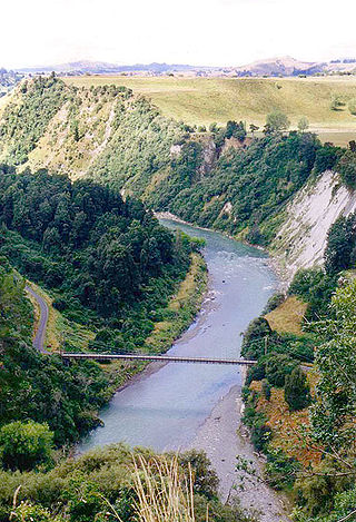
The Rangitīkei River is one of New Zealand's longest rivers, 253 kilometres (157 mi) long.

The Aorere River is in the Tasman District of the South Island of New Zealand that flows from headwaters in the alpine regions of the Kahurangi National Park. It has a catchment area of 573 km2 (221 sq mi), representing around 11% of the total area of Kahurangi National Park. The river flows generally northwards for 40 km (25 mi) before draining into Golden Bay at the town of Collingwood. The Heaphy Track's northeastern end is in the upper valley of the Aorere.

The Heaphy Track is a popular tramping and mountain biking track in the north west of the South Island of New Zealand. It is located within the Kahurangi National Park and classified as one of New Zealand's ten Great Walks by the Department of Conservation. Named after Charles Heaphy, the track is 78.4 kilometres (48.7 mi) long and is usually walked in four or five days. The track is open for shared use with mountain bikers in the winter season from 1 May to 30 September each year. The southern end of the track is at Kōhaihai, north of Karamea on the northern West Coast, and the northern end is in the upper valley of the Aorere River, Golden Bay.

The Waimakariri River is one of the largest rivers in Canterbury, on the eastern coast of New Zealand's South Island. It flows for 151 kilometres (94 mi) in a generally southeastward direction from the Southern Alps across the Canterbury Plains to the Pacific Ocean.
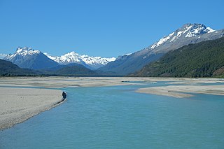
The Dart River flows through rugged forested country in the southwestern South Island of New Zealand. Partly in Mount Aspiring National Park, it flows south-west and then south for 60 kilometres (37 mi) from its headwaters in the Southern Alps and the Dart Glacier, eventually flowing into the northern end of Lake Wakatipu near Glenorchy.

The Manawatū River is a major river of the lower North Island of New Zealand. The river flows from the Ruahine Ranges, through both the Manawatū Gorge and the city of Palmerston North, and across the Manawatū Plains to the Tasman Sea at Foxton.

Lake Rotoiti, previously also known as Lake Arthur, is a lake in the Tasman Region of New Zealand. It is a substantial mountain lake within the borders of Nelson Lakes National Park. The lake is fed by the Travers River, water from the lake flows into the Buller River. The lake is surrounded by beech forest and is 82 metres (269 ft) deep. Saint Arnaud is a small community at the northern end of the lake.

The Arahura River, for a time called the Brunner River after the explorer Thomas Brunner, is a river located on the West Coast of the South Island of New Zealand. In 1846 Brunner and Heaphy sketched and described a Māori settlement they called Araura [sic] (Arahura).

Cobden is a suburb to the north of Greymouth on the West Coast of New Zealand. The Grey River separates Cobden from the rest of Greymouth. To the north is the Rapahoe Range, also called the Twelve Apostles Range. State Highway 6 skirts the south-eastern edge of Cobden.
The Heaphy River is a river of the northwestern South Island of New Zealand. It flows through Kahurangi National Park, rising on the northern slopes of Amohia Peak and initially flowing northwest before turning southwest to reach the Tasman Sea 30 kilometres north of Karamea. Stages of the Heaphy Track follow the lower course of this river, with the track reaching the coast at the river's mouth. The Heaphy River is located in the Buller District.

The Karamea Aerodrome serves the town of Karamea, in the South Island of New Zealand. It is a non certificated aerodrome located around 1.4 kilometres (0.87 mi) northwest of the town.

The Lewis River is a tributary of the Heaphy River in New Zealand's Kahurangi National Park.

The Inland Pack Track is a trail in the Paparoa National Park on West Coast of New Zealand. The full length of the trail commences at the Punakaiki River in the south, and ends at the mouth of the Fox River in the north. It takes two or three days to complete the track.

The Wangapeka Track is a tramping track in the north-west of the South Island of New Zealand. It is one of the main tramping tracks in the Kahurangi National Park, a protected area managed by the Department of Conservation. The route traverses the southern end of the park, from the historic Wangapeka goldfields area west of Tapawera, to the coastal plains of the West Coast at Little Wanganui. The route is 59 km (37 mi) long, and crosses the Wangapeka and Little Wanganui saddles, each over 1,000 m (3,300 ft) in elevation. The track passes through the valleys of the Wangapeka River, Karamea River, Taipō River and Little Wanganui River. The majority of the track is in river valleys and under forest cover, with small sections in tussock land at Stag Flat and the Little Wanganui Saddle. It typically takes walkers 4–6 days to complete the route.

Brown River is a river in Tasman, New Zealand.


