
The South Island, also officially named Te Waipounamu, is the larger of the two major islands of New Zealand in surface area, the other being the smaller but more populous North Island. It is bordered to the north by Cook Strait, to the west by the Tasman Sea, and to the south and east by the Pacific Ocean. The South Island covers 150,437 square kilometres (58,084 sq mi), making it the world's 12th-largest island. At low altitude, it has an oceanic climate.

Manapōuri Power Station is an underground hydroelectric power station on the western arm of Lake Manapouri in Fiordland National Park, in the South Island of New Zealand. At 854 MW installed capacity, it is the largest hydroelectric power station in New Zealand, and the second largest power station in New Zealand. The station is noted for the controversy and environmental protests by the Save Manapouri Campaign against raising the level of Lake Manapouri to increase the station's hydraulic head, which galvanised New Zealanders and were one of the foundations of the New Zealand environmental movement.

Tasman District is a local government district in the northwest of the South Island of New Zealand. It borders the Canterbury Region, West Coast Region, Marlborough Region and Nelson City. It is administered by the Tasman District Council, a unitary authority, which sits at Richmond, with community boards serving outlying communities in Motueka and Golden Bay / Mohua. The city of Nelson has its own unitary authority separate from Tasman District, and together they comprise a single region in some contexts, but not for local government functions or resource management (planning) functions.

The Buller River is a river in the South Island of New Zealand. One of the country's longest rivers, it flows for 170 kilometres (110 mi) from Lake Rotoiti through the Buller Gorge and into the Tasman Sea near the town of Westport. Within the Buller Gorge and downstream from the Deepdale River joining, the Buller crosses from Tasman District into Buller District. As Rotoiti itself is fed by the Travers River it can be claimed that the Buller's source is at the headwaters of the Travers, on the northern slopes of Mount Travers in the Saint Arnaud Range. The Paparoa Range separates the Buller River from the Grey River. A number of flora and fauna are found in the Buller catchment, many of these extending onto the slopes of the Paparoa Range.

The Waitaki River is a large braided river that drains the Mackenzie Basin and runs some 209 kilometres (130 mi) south-east to enter the Pacific Ocean between Timaru and Oamaru on the east coast of the South Island of New Zealand. It starts at the confluence of the Ōhau River and the Tekapo River, now in the head of the artificial Lake Benmore, these rivers being fed by three large glacial lakes, Pukaki, Tekapo, and Ōhau at the base of the Southern Alps. The Waitaki flows through Lake Benmore, Lake Aviemore and Lake Waitaki, these lakes being contained by hydroelectric dams, Benmore Dam, Aviemore Dam and Waitaki Dam. The Waitaki has several tributaries, notably the Ahuriri River and the Hakataramea River. It passes Kurow and Glenavy before entering the Pacific Ocean. The River lends its name the Waitaki District on the south side of the river bank.

Murchison is a town in the Tasman Region of the South Island of New Zealand. It is near the western end of the "Four Rivers Plain", at the confluence of the Buller River and the Matakitaki River. The other two rivers are the Mangles River, and the Matiri River. It is a rural service town for the surrounding mixed farming district, approximately halfway between Westport and Nelson. Murchison was named after the Scottish geologist Roderick Murchison, one of the founders of the Royal Geographical Society.

Lake Pukaki is the largest of three roughly parallel alpine lakes running north–south along the northern edge of the Mackenzie Basin on New Zealand's South Island. The others are Lakes Tekapo and Ohau. All three lakes were formed when the terminal moraines of receding glaciers blocked their respective valleys, forming moraine-dammed lakes. The Alps2Ocean mountain bike trail follows the edge of Lake Pukaki for part of its length.
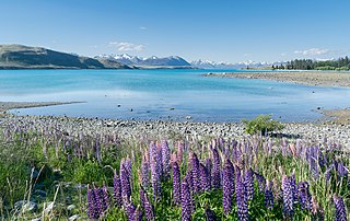
Lake Tekapo (Takapō) is the second-largest of three roughly parallel lakes running north–south along the northern edge of the Mackenzie Basin in the South Island of New Zealand. It covers an area of 83 square kilometres (32 sq mi), and is at an altitude of 710 metres (2,330 ft) above sea level.
This is a yet-unnamed Powelliphanta species, provisionally known as Powelliphanta "Matiri". This is one of the amber snails. It is an undescribed species of large, carnivorous land snail, a terrestrial pulmonate gastropod mollusc in the family Rhytididae.

Despite abundant natural resources and a relatively small population, New Zealand is a net importer of energy, in the form of petroleum products. The ratio of non-renewable and renewable energy sources was fairly consistent from 1975 to 2008, with about 70 percent of primary energy supply coming from hydrocarbon fuels. This ratio decreased to about 60 percent in 2018. The proportion of non-renewable energy varies annually, depending on water flows into hydro-electricity lakes and demand for energy. In 2018, approximately 60% of primary energy was from non-renewable hydrocarbon fuels and 40% was from renewable sources. In 2007 energy consumption per capita was 120 gigajoules. Per capita energy consumption had increased 8 per cent since 1998. New Zealand uses more energy per capita than 17 of 30 OECD countries. New Zealand is one of 13 OECD countries that does not operate nuclear power stations.

Hydroelectric power in New Zealand has been a part of the country's energy system for over 100 years and continues to provide more than half of the country's electricity needs. Hydroelectricity is the primary source of renewable energy in New Zealand. Power is generated the most in the South Island and is used most in the North Island.
Aratiatia Power Station is a hydroelectric power station on the Waikato River, in the North Island of New Zealand. It is the first hydroelectric power station on the Waikato River, and is located 13 kilometres (8.1 mi) downstream of Lake Taupo. Aratiatia is owned and operated by Mercury Energy.

The Matiri Project is a run-of-river hydroelectric scheme at Lake Matiri and the Matiri River in the South Island of New Zealand. The project takes water from a series of intake weirs at Lake Matiri and pipes it through a 2.4km long buried pipeline to a power station.
New Zealand Energy is a New Zealand company, operating small hydroelectric power stations in Haast, Fox, Ōpunake and Raetihi.

The Karamea River is a river of New Zealand. It is located in the Tasman and West Coast Regions of the South Island. The river rises within Kahurangi National Park in the Matiri Range of the Southern Alps. The river rises to the east of Mount Allen, meandering west briefly before turning north. After some 25 kilometres it again turns west, to enter a series of small lakes where its waters are joined by those of the Roaring Lion River.
The Orikaka River is a river of the West Coast Region of New Zealand's South Island. It flows southwest from the southern end of the Matiri Range before turning south to flow into the Buller River five kilometres to the west of Inangahua.

The Wangapeka River is a river of the Tasman Region of New Zealand's South Island. It rises in two branches, the North Branch and the South Branch, in the Matiri Range within Kahurangi National Park, meeting some 25 kilometres southeast of Karamea. It flows generally northeast to reach the Motueka River 30 kilometres south of Motueka.

Alpinacris crassicauda is a species of grasshopper only known from West Coast Region and Tasman Region, New Zealand. The genus Alpinacris is endemic to the South Island of New Zealand. A. crassicauda was described in 1967 by Robert Sidney Bigelow, with a type locality of Lead Hills, Boulder Lake. A male holotype and paratype are deposited in the Canterbury Museum, Christchurch. Like all of New Zealand sub-alpine and alpine grasshoppers A. crassicauda has a 2 or 3 years life cycle. The eggs must ‘overwinter’ before they will hatch. Hoppers are found throughout the year and adult grasshoppers can be found throughout the New Zealand summer between December and April. The adult A. crassicauda do not overwinter.

Southland is New Zealand's southernmost region. It consists mainly of the southwestern portion of the South Island and Stewart Island/Rakiura. It includes Southland District, Gore District and the city of Invercargill. The region covers over 3.1 million hectares and spans over 3,400 km of coast.

Lyperobius clarkei is a flightless weevil found in alpine areas of Buller and Nelson in the South Island of New Zealand.
