
Powelliphanta is a genus of large, air-breathing land snails, pulmonate gastropods in the family Rhytididae, found only in New Zealand. They are carnivorous, eating invertebrates, mostly native earthworms. Often restricted to very small areas of moist forest, they are prey to introduced mammalian predators, and many species are threatened or endangered.

Fiordland National Park occupies the southwest corner of the South Island of New Zealand. It is by far the largest of the 13 national parks in New Zealand, with an area of 12,607 square kilometres (4,868 sq mi), and a major part of the Te Wāhipounamu a UNESCO World Heritage Site. The park is administered by the Department of Conservation. The southern ranges of the Southern Alps cover most of Fiordland National Park and, combined with the deep glacier-carved valleys.

The Buller River is a river in the South Island of New Zealand. The Buller has the highest flow of any river in the country during floods, though it is only the 13th longest river; it runs for 177 km (110 mi) from Lake Rotoiti through the Buller Gorge and into the Tasman Sea near the town of Westport. A saddle at 710 m (2,330 ft) separates the Buller from the Motupiko River and that is divided from the Wairau River by a 695 m (2,280 ft) saddle, both aligned along the Alpine Fault, as is the top of the Buller valley.

Lake Rotoroa lies within the borders of Nelson Lakes National Park in the South Island, New Zealand. The lake is fed by the D'Urville and Sabine rivers.

Nelson Lakes National Park is in the South Island of New Zealand, at the northern end of the Southern Alps. It was created in 1956. The park contains beech forests, multiple lakes, snow-covered mountains and valleys created by glaciers during the ice ages.

Kahurangi National Park in the northwest of the South Island of New Zealand is the second largest of the thirteen national parks of New Zealand. It was gazetted in 1996 and covers 5,193 km2 (2,005 sq mi), ranging from the Buller River near Murchison in the south, to the base of Farewell Spit in Golden Bay in the north. The park has no single dominant landform, but includes an unusually wide variety of landscapes, including mountain ranges, rivers, gorges, raised peneplains and karst features such as caves and arches. Many of the landforms within the park are considered to be nationally or internationally significant.

Arthur's Pass National Park is located in the South Island of New Zealand and covers 1,185 km2 of mostly mountainous terrain. Adjacent to it lies Craigieburn Forest Park. The park is administered by the Department of Conservation.

Mount Aspiring National Park is in the Southern Alps of the South Island of New Zealand, north of Fiordland National Park, situated in Otago and Westland regions. The park forms part of the Te Wahipounamu World Heritage Site.

The Tararua Range, often referred to as the Tararua Ranges or Tararua, is one of several mountain ranges in the North Island of New Zealand.

Saint Arnaud is a small alpine village in the Tasman district of New Zealand's South Island, west of the mountains of the Saint Arnaud Range and 90 kilometres southwest of Nelson near the historic Tophouse Settlement. It is situated at the northern end of Lake Rotoiti.

Mount Burnett is a hill in Kahurangi National Park, in Golden Bay / Mohua, New Zealand.

Mount Murchison is a mountain on the West Coast Range, located in the West Coast region of Tasmania, Australia.
This is a yet-unnamed Powelliphanta species, provisionally known as Powelliphanta "Nelson Lakes". This is one of the amber snails. It is an undescribed species of large, carnivorous land snail, a terrestrial pulmonate gastropod mollusc in the family Rhytididae. The area above the bush line on Mount Murchison in the Braeburn Range is one of three isolated habitats for this species.

The Hunter Mountains of Lake Manapouri, New Zealand, were named by surveyor James McKerrow after the famous anatomist John Hunter. The Hunter Mountain Range covers an area between The South Arm and Hope Arm of Lake Manapouri South to the Green Lake.
The Tutaki River is a river of the Tasman Region of New Zealand's South Island. It flows north from its sources southwest of Lake Rotoroa to reach the Mangles River 10 kilometres east of Murchison.
Mount Franklin is a peak in the Nelson Lakes National Park in the Tasman Region of New Zealand. It is the northernmost – and highest – of New Zealand's four Mounts Franklin, located 15 kilometres (9.3 mi) south of Lake Rotoroa. It is the highest peak in the Tasman Region, just two metres higher than the nearby Mount Travers.
The Tiraumea River is a river of the Tasman Region of New Zealand's South Island. The river has its source on the slopes of Mount Hutton at the southern end of the Braeburn Range, and runs northwest from the Tiraumea Saddle. It reaches the Tutaki River 10 kilometres southeast of Murchison. The area is known for hunting.

The Two Thumb Range is a range of mountains in the Canterbury Region of New Zealand's South Island. It is located to the east of Lake Tekapo and has several peaks which rise to around 2,500 metres (8,200 ft). The southern end of the range contains one of Canterbury's main skifields, Mount Dobson.

The Wangapeka Track is a tramping track in the north-west of the South Island of New Zealand. It is one of the main tramping tracks in the Kahurangi National Park, a protected area managed by the Department of Conservation. The route traverses the southern end of the park, from the historic Wangapeka goldfields area west of Tapawera, to the coastal plains of the West Coast at Little Wanganui. The route is 59 km (37 mi) long, and crosses the Wangapeka and Little Wanganui saddles, each over 1,000 m (3,300 ft) in elevation. The track passes through the valleys of the Wangapeka River, Karamea River, Taipō River and Little Wanganui River. The majority of the track is in river valleys and under forest cover, with small sections in tussock land at Stag Flat and the Little Wanganui Saddle. It typically takes walkers 4–6 days to complete the route.
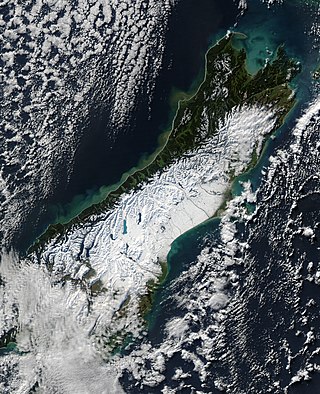
The South Island, with an area of 150,437 km2 (58,084 sq mi), is the largest landmass of New Zealand; it contains about one-quarter of the New Zealand population and is the world's 12th-largest island. It is divided along its length by the Southern Alps, the highest peak of which is Aoraki / Mount Cook at 3,724 metres (12,218 ft), making it 9th-highest island, with the high Kaikōura Ranges to the northeast. There are eighteen peaks of more than 3,000 metres (9,800 ft) in the South Island. The east side of the island is home to the Canterbury Plains while the West Coast is famous for its rough coastlines such as Fiordland, a very high proportion of native bush, and Fox and Franz Josef Glaciers. The dramatic landscape of the South Island has made it a popular location for the production of several films, including The Lord of the Rings trilogy and The Chronicles of Narnia: The Lion, the Witch and the Wardrobe. It lies at similar latitudes to Tasmania, and parts of Patagonia in South America.
