
Abel Janszoon Tasman was a Dutch seafarer and explorer, best known for his voyages of 1642 and 1644 in the service of the Dutch East India Company (VOC).

Franklin District was a New Zealand territorial authority that lay between the Auckland metropolitan area and the Waikato Plains. As a formal territory, it was abolished on 31 October 2010 and divided between Auckland Council in the Auckland Region to the north and Waikato and Hauraki districts in the Waikato region to the south and east. The Auckland portion is now part of the Franklin Ward, which also includes rural parts of the former Manukau City.

Tasman District is a local government district in the northwest of the South Island of New Zealand. It borders the Canterbury Region, West Coast Region, Marlborough Region and Nelson City. It is administered by the Tasman District Council, a unitary authority, which sits at Richmond, with community boards serving outlying communities in Motueka and Golden Bay / Mohua. The city of Nelson has its own unitary authority separate from Tasman District, and together they comprise a single region in some contexts, but not for local government functions or resource management (planning) functions.

The Haast River / Awarua is a river on the West Coast of the South Island of New Zealand. The Māori name for the river is Awarua. It drains the western watershed of the Haast Pass. The Haast River is 100 kilometres (62 mi) in length, and enters the Tasman Sea near Haast township. The river's main tributary is the Landsborough River.

Abel Tasman National Park is a national park at the north end of New Zealand's South Island. It covers 237.1 km2 (91.5 sq mi) of land between Golden Bay / Mohua and Tasman Bay / Te Tai-o-Aorere, making it the smallest of New Zealand's national parks. Despite this, the park is one of the most visited, partially due to the popularity of the Abel Tasman Coast Track which spans 60 km (37 mi) along the eastern and northern coastal areas of the park.

The Hollyford River / Whakatipu Kā Tuka is in the southwest of the South Island of New Zealand. It runs for 72 kilometres (45 mi) through Fiordland, its sources being close to the Homer Tunnel and in Gertrude Valley in the southern Darran Mountains.

Tasman Bay, originally known in English as Blind Bay, is a large V-shaped bay at the north end of New Zealand's South Island. Located in the centre of the island's northern coast, it stretches along 120 kilometres (75 mi) of coastline and is 70 kilometres (43 mi) across at its widest point. It is an arm of the Tasman Sea, lying on the western approach to Cook Strait.

The Tarawera River is in the Bay of Plenty Region in the North Island of New Zealand.

Saint Arnaud is a small alpine village in the Tasman district of New Zealand's South Island, west of the mountains of the Saint Arnaud Range and 90 kilometres southwest of Nelson near the historic Tophouse Settlement. It is situated at the northern end of Lake Rotoiti.
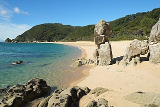
The Abel Tasman Coast Track is a 60 kilometres (37 mi) long walking track within the Abel Tasman National Park in New Zealand. It extends from Mārahau in the south to Wainui in the north, with many side tracks. It is one of two main tracks through the park, the other being the Abel Tasman Inland Track, which stretches for 38 km between Tinline Bay and Torrent Bay off the main coastal track. The coastal track is well sheltered, and with mild weather in all seasons, it is accessible and open throughout the year.

State Highway 6 is a major New Zealand state highway. It extends from the Marlborough region in the northeastern corner of the South Island across the top of the island, then down the length of the island, initially along the West Coast and then across the Southern Alps through inland Otago and finally across the Southland Plains to the island's south coast. Distances are measured from north to south.
The Mārahau River is a river of the Tasman Region, New Zealand. The river originated on the eastern slopes of Mount Evans in the Abel Tasman National Park, and flows south-east towards Sandy Bay, a bay of Tasman Bay, north of the village of Mārahau.

The Torrent River is a river of the Tasman Region of New Zealand's South Island. It flows east to reach Torrent Bay on the Tasman Bay / Te Tai-o-Aorere coast of the Abel Tasman National Park. The Abel Tasman Track crosses the river close to its mouth.
The Wainui River is a river of the Tasman Region of New Zealand's South Island. Wainui is a Māori language term and the umbrella entity for the three local iwi gives a meaning of "where the tidal flow leaves a big expanse of bay empty".

Golden Bay is a large shallow bay in New Zealand's Tasman District, near the northern tip of the South Island. An arm of the Tasman Sea, the bay lies northwest of Tasman Bay and Cook Strait. It is protected in the north by Farewell Spit, a 26 km long arm of fine golden sand that is the country's longest sandspit. The Aorere and Tākaka rivers are the major waterways to flow into the bay from the south and the west.

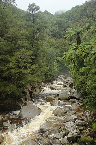
Wainui Falls is a 20-metre (66 ft) waterfall in Wainui Bay, in the Tasman region of New Zealand. The waterfall is part of the Wainui River and cascades over granite bedrock into a deep pool at its base. It is the largest and most accessible waterfall in the Abel Tasman National Park and the Nelson-Golden Bay area, and can be reached via the short Wainui Falls Track. The track is popular as a day walk among tourists, and while the waters of the Wainui River can be too cold for swimming much of the year, the plunge pool is a favoured swimming hole in the summer months.

Wainui Bay is within Golden Bay / Mohua, and at the south-eastern end of Golden Bay, in the Tasman Region of the South Island, New Zealand.
Ngāti Tūmatakōkiri is a Māori iwi (tribe) of New Zealand, who arrived on the Kurahaupō waka. In the 1600s the iwi settled northwestern South Island, becoming a major power in the region until the 1800s. In 1642, members of Ngāti Tūmatakōkiri made the first known contact between Europeans and Māori, when Dutch explorer Abel Tasman visited Golden Bay / Mohua.

East Tākaka is a settlement in the Tasman District of New Zealand. It is located in Golden Bay, 8 kilometres (5.0 mi) south of Tākaka.


