
Aoraki / Mount Cook is the highest mountain in New Zealand. Its height, as of 2014, is listed as 3,724 metres. It is situated in the Southern Alps, the mountain range that runs the length of the South Island. A popular tourist destination, it is also a favourite challenge for mountain climbers. Aoraki / Mount Cook consists of three summits: from south to north, the Low Peak, the Middle Peak and the High Peak. The summits lie slightly south and east of the main divide of the Southern Alps, with the Tasman Glacier to the east and the Hooker Glacier to the southwest. Mount Cook is ranked 10th in the world by topographic isolation.

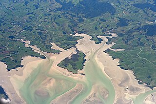
Abel Tasman National Park is a national park at the north end of New Zealand's South Island. It covers 237.1 km2 (91.5 sq mi) of land between Golden Bay / Mohua and Tasman Bay / Te Tai-o-Aorere, making it the smallest of New Zealand's national parks. Despite this, the park is one of the most visited, partially due to the popularity of the Abel Tasman Coast Track which spans 60 km (37 mi) along the eastern and northern coastal areas of the park.

Farewell Spit is a narrow sand spit at the northern end of the Golden Bay, in the South Island of New Zealand. The spit includes around 25 km (16 mi) of stable land and another 5 km (3.1 mi) of mobile sand spit running eastwards from Cape Farewell, the northern-most point of the South Island. Farewell Spit is the longest sand spit in New Zealand, and is a legally protected Nature Reserve. The area is designated as a Ramsar wetland site and an East Asian–Australasian Flyway Shorebird Network site. Farewell Spit is administered by the Department of Conservation as a seabird and wildlife reserve. Apart from a small area at the base of the spit, it is closed to the public except through organised tours. Conservation initiatives are in progress towards eliminating mammalian predators from Farewell Spit, including a proposal for a predator-proof fence.

Tasman Glacier is the largest glacier in New Zealand, and one of several large glaciers which flow south and east towards the Mackenzie Basin from the Southern Alps in New Zealand's South Island.
Aotea Harbour is a settlement and smallest of three large natural inlets in the Tasman Sea coast of the Waikato region of New Zealand's North Island. It is located between Raglan Harbour to the north and Kawhia Harbour to the south, 30 kilometres southwest of Hamilton.
Kawhia Harbour is one of three large natural inlets in the Tasman Sea coast of the Waikato region of New Zealand's North Island. It is located to the south of Raglan Harbour, Ruapuke and Aotea Harbour, 40 kilometres southwest of Hamilton. Kawhia is part of the Ōtorohanga District and is in the King Country. It has a high-tide area of 68 km2 (26 sq mi) and a low-tide area of 18 km2 (6.9 sq mi). Te Motu Island is located in the harbour.
The Abel Tasman Coast Track is a 60 kilometres (37 mi) long walking track within the Abel Tasman National Park in New Zealand. It extends from Mārahau in the south to Wainui in the north, with many side tracks. It is one of two main tracks through the park, the other being the Abel Tasman Inland Track, which stretches for 38 km between Tinline Bay and Torrent Bay off the main coastal track. The coastal track is well sheltered, and with mild weather in all seasons, it is accessible and open throughout the year.

The Turakina River is a river of the southwestern North Island of New Zealand. It flows generally southwestward from its source south of Waiouru, roughly paralleling the larger Whangaehu River, and reaches the Tasman Sea 20 kilometres (12 mi) southeast of Whanganui.

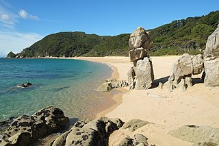
Tata Beach is a beach and small coastal settlement of predominantly holiday houses in the South Island, New Zealand. Found in the Golden Bay region, it is approximately 14 kilometres (8.7 mi) north-east of Tākaka.
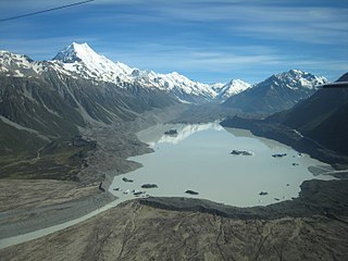
Tasman Lake is a proglacial lake formed by the recent retreat of the Tasman Glacier in New Zealand's South Island.
The Wainui River is a river of the Tasman Region of New Zealand's South Island. Wainui is a Māori language term and the umbrella entity for the three local iwi gives a meaning of "where the tidal flow leaves a big expanse of bay empty".
Golden Bay / Mohua is a large shallow bay in New Zealand's Tasman District, near the northern tip of the South Island. An arm of the Tasman Sea, the bay lies northwest of Tasman Bay / Te Tai-o-Aorere and Cook Strait. It is protected in the north by Farewell Spit, a 26 km (16 mi) long arm of fine golden sand that is the country's longest sandspit. The Aorere and Tākaka rivers are the major waterways to flow into the bay from the south and the west.

The Cobb Reservoir is a hydro storage lake fed by the Cobb River in the Tasman District of the South Island of New Zealand. The reservoir feeds the Cobb Power Station and is 819 metres (2,687 ft) above sea level but drops significantly with low rainfall. Cobb Reservoir is the highest hydro storage lake in New Zealand, and is entirely surrounded by Kahurangi National Park. The reservoir, dam, penstock and powerhouse are excluded from the national park.

Tonga Island is a small (0.15 km2) island in Tasman Bay / Te Tai-o-Aorere, off the northern coast of the South Island of New Zealand. It lies within the Abel Tasman National Park, about 1 kilometre (0.62 mi) off Onetahuti Beach. The island has a flourishing fur seal colony, and is surrounded by the Tonga Island Marine Reserve, which was inaugurated in 1993.

The tiny settlement of Pūponga in New Zealand is the northernmost settlement in the South Island. It is in the Tasman District, 18 kilometres (11 mi) north of Collingwood, at the foot of Farewell Spit. The spit's airstrip, Triangle Flat Airstrip is just northeast of Pūponga. The settlement of Pūponga is inland; the settlement located on the coast is called Port Pūponga.

Rawhiti Cave, also known as Manson Cave, is a single large limestone cave in the hillside of the Dry Creek Valley 7 kilometres (4.3 mi) southeast of Tākaka on the South Island of New Zealand. It is referred to as Manson Cave in the NZ Topo Map, after owners in the early 20th century, however the cave is known as Rawhiti Cave locally, and on DoC information panels and in brochures.
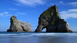
The Archway Islands are a group of four rock stacks or small islands in New Zealand. The islands are located in Tasman District's Golden Bay / Mohua at Wharariki Beach.

Wainui Bay is within Golden Bay / Mohua, and at the south-eastern end of Golden Bay, in the Tasman Region of the South Island, New Zealand.

Wharariki Ecosanctuary is a wildlife sanctuary within a predator-proof fence at Cape Farewell, New Zealand.

Awaroa Inlet is a remote, alluring body of water within the Abel Tasman National Park, at the northern end of Tasman Bay, in the Tasman Region of the South Island, New Zealand.

