
Mount Tasman is New Zealand's second-highest mountain, rising to a height of 3,497 metres (11,473 ft). It is located in the Southern Alps of the South Island, four kilometres to the north of its larger neighbour, Aoraki / Mount Cook. Unlike Aoraki / Mount Cook, Mount Tasman sits on the South Island's Main Divide, on the border between Aoraki / Mount Cook National Park and Westland Tai Poutini National Park. It is the highest point in Westland District.

The Sisters is a group of three main islands located 16 kilometres (10 mi) north of Cape Pattison, Chatham Island. They are the northernmost members of the Chatham Archipelago, located 800 kilometres (497 mi) east of New Zealand's South Island.
The Tītī / Muttonbird Islands are an island group near Stewart Island in the far south of New Zealand. The islands are not permanently inhabited, and are named for the traditional seasonal harvesting ("muttonbirding") of the sooty shearwater by Māori. These birds are known as "muttonbirds" due to their supposedly mutton-like taste.

The Hokitika River is in the West Coast of the South Island of New Zealand. It is about 64 kilometers (40 mi) long, beginning in the Southern Alps, emerging from the narrow Hokitika Gorge after merging with the Whitcombe River, and flowing into the Tasman Sea just south of the town of Hokitika. The river then feeds into the offshore Hokitika Canyon, which merges with the Cook Canyon to form the Cook Channel. The canyons extend to about 650 km (400 mi) and are important spawning areas for hoki, hake and orange roughy.

The Waiheke River is a river of the West Coast Region of New Zealand's South Island. It flows west from its origins on Mount Barron in the Southern Alps to reach the Ahaura River, which it forms where it joins the Tūtaekurī River, 20 kilometres northwest of Lake Sumner.
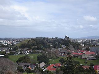
Mount Saint John, is a volcanic scoria cone and Tūpuna Maunga in Epsom, in the Auckland volcanic field of New Zealand.

Kohinurākau or Kōhinerākau is a 490 m (1,610 ft) mountain in the Kohinurākau Range, 8.5 km (5.3 mi) south-southwest of Havelock North in the Hawke's Bay region of New Zealand. The mountain is the main television and FM radio transmitter site for Napier, Hastings and the wider Hawke's Bay region.
Bulli Point is a point on Lake Taupō, in the central North Island of New Zealand. The point is a popular spot for rock jumping.
Bay of Many Coves, or Miritū Bay, is a bay in Queen Charlotte Sound, New Zealand, east of Ruakākā Bay and Blackwood Bay. It is one of the larger bays of the inner sound, located north of the Tory Channel it is vulnerable to southerly winds.
Ōnahau Bay is a large bay in Queen Charlotte Sound, New Zealand, just north-east of Grove Arm and meeting it at Houhou Point.
Ruakākā Bay is a bay in Queen Charlotte Sound, New Zealand, sitting between Blackwood Bay and Bay of Many Coves / Miritū Bay.
Bench Island or Te Wāhitauā are unofficial names for an island off the east coast of Stewart Island, New Zealand. It was named 'The Bench' by Captain James Cook. To the east of the island are small islands called Flat Rock and The Haystacks. It is not to be confused with the neighbouring Ruapuke Island which was also named Bench Island.
Calliope Island is an unofficial name for an island near Whangārei, New Zealand. The tiny, roughly triangular-shaped island, is located in Urquhart Bay, just within the mouth of Whangārei Harbour.
Catherine Island is an unofficial name for an island in the Gold Arm of Taiporoporo / Charles Sound in the South Island of New Zealand.
Adams Rocks is an island of the Auckland Islands in New Zealand.
Alert Stack is an outlying island of New Zealand. It is a part of the Snares Islands, lying southwest of North East Island.
Anvil Islet is an islet in the Hauraki Gulf of New Zealand. It is west of the Great Barrier Island, and south of Mahuki / Anvil Island.
Archway Island is an island in the Auckland Region of New Zealand. It lies to the south west of Kawau Island.
Archway Island is an island in the Northland Region of New Zealand. It lies on the south part of the Poor Knights Islands.
Archway Island is an outlying island of New Zealand. It is part of the Antipodes Island Group, and lays directly north of Bollons Island.
