
Fiordland is a geographic region of New Zealand in the south-western corner of the South Island, comprising the western-most third of Southland. Most of Fiordland is dominated by the steep sides of the snow-capped Southern Alps, deep lakes, and its steep, glacier-carved and now ocean-flooded western valleys. The name "Fiordland" comes from a variant spelling of the Scandinavian word for this type of steep valley, "fjord". The area of Fiordland is dominated by, and very roughly coterminous with, Fiordland National Park, New Zealand's largest National Park.

Aoraki/Mount Cook National Park is in the South Island of New Zealand, near the town of Twizel. Aoraki / Mount Cook, New Zealand's highest mountain, and Aoraki/Mount Cook Village lie within the park. The area was gazetted as a national park in October 1953 and consists of reserves that were established as early as 1887 to protect the area's significant vegetation and landscape.

Fiordland National Park occupies the southwest corner of the South Island of New Zealand. It is by far the largest of the 14 national parks in New Zealand, with an area of 12,607 square kilometres (4,868 sq mi), and a major part of the Te Wahipounamu World Heritage site. The park is administered by the Department of Conservation.
The Travers River is in the South Island of New Zealand.

Mount Aspiring National Park is in the Southern Alps of the South Island of New Zealand, north of Fiordland National Park, situated in Otago and Westland regions. The park forms part of the Te Wahipounamu World Heritage site.

Kiewa River, a perennial river that is part of the Murray catchment within the Murray-Darling basin, is located in the Alpine bioregion, in the Australian state of Victoria.
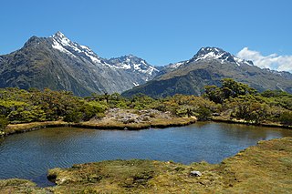
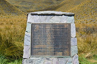
The Routeburn Track is a world-renowned, 32 km tramping (hiking) track found in the South Island of New Zealand. The track is usually completed by starting on the Queenstown side of the Southern Alps, at the northern end of Lake Wakatipu, and finishing on the Te Anau side, at the Divide, several kilometres from the Homer Tunnel to Milford Sound.

The Matukituki River is found in the Southern Alps of New Zealand's South Island. Both the West Branch and the East Branch originate from the Main Divide mountain ranges near Mount Aspiring and their largely glacier-fed waters flow for approximately 20 kilometres (12 mi) each before joining near Camerons Flat. After this confluence, the Matukituki River leaves the boundaries of Mount Aspiring National Park and continues for another 30 kilometres (19 mi) until it drains into Lake Wanaka at the lake's southwestern edge.

Haupapa / Tasman Glacier is the largest glacier in New Zealand, and one of several large glaciers which flow south and east towards the Mackenzie Basin from the Southern Alps in New Zealand's South Island.

Westland Tai Poutini National Park is located on the western coast of New Zealand's South Island. Established in 1960, the centenary of the European settlement of Westland District, it covers 1,320 km², and extends from the highest peaks of the Southern Alps to a wild and remote coastline. It borders the Aoraki/Mount Cook National Park along the Main Divide.

Hooker Glacier is one of several glaciers close to the slopes of Aoraki / Mount Cook in the Southern Alps of New Zealand. It is not as large as its neighbour, the Tasman Glacier, measuring 11 kilometres in length.

The Tararua Range, often referred to as the Tararua Ranges or the Tararuas, is one of several mountain ranges in the North Island of New Zealand. They form a ridge running parallel with the east coast of the island between East Cape and Wellington.

The St James Walkway is a 66 kilometres (41 mi)-long subalpine tramping track located in the Lewis Pass area of the South Island of New Zealand. It is administered by the Department of Conservation.
The Doubtful River is a river in the Canterbury Region of New Zealand. It rises near Mount Barron and flows south then south-east through Lake Sumner Forest Park, reaching the Boyle River 40 kilometres (25 mi) west of Hanmer Springs. The Doubtful Range lies to the south. The Doubtless River and Devilskin Stream are tributaries entering from the north.

The Hapuku River is a river of New Zealand. It begins in the Seaward Kaikoura Range and flows south-east to enter the South Pacific at Hapuka, between Clarence and Kaikoura. The name comes from the Māori word Hapuku or Hapuka, a deep-water marine fish.
Hunting is a popular recreational pursuit and a tourist activity in New Zealand with numerous books and magazines published on the topic. Unlike most other developed countries with a hunting tradition, there are no bag-limits or seasons for hunting large game in New Zealand. Hunting in National Parks is a permitted activity. The wide variety of game animals and the limited restrictions means hunting is a popular pastime which has resulted in a high level of firearms ownership among civilians.

Pureora Forest Park is a 760-square-kilometre (290 sq mi) protected area in the North Island of New Zealand. Within its rich rain forest are an abundance of 1,000-year-old podocarp trees. It is "recognised as one of the finest rain forests in the world". Established in 1978, after a series of protests and tree sittings, the park is one of the largest intact tracts of native forest in the North Island and has high conservation value due to the variety of plant life and animal habitats available. New Zealand's largest totara tree is located nearby on private land.
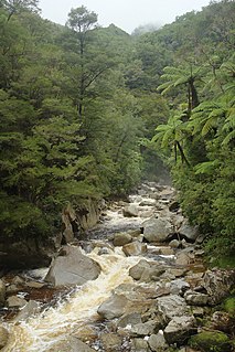
The Robinson River is a river in the West Coast Region of the South Island of New Zealand. It is a tributary of the Upper Grey River and much of the river lies within the Lake Sumner Conservation Park. Rising on the slopes of Mount Boscawen on the main divide about 12 kilometres (7.5 mi) south of the Lewis Pass, the river runs west-southwest along a straight, narrow valley before turning northwest to reach the Upper Grey.
The Wainui River is a river of the Tasman Region of New Zealand's South Island. It flows north through Abel Tasman National Park from its sources on the slopes of Mount Evans to reach the small Wainui Bay, an indentation close to the eastern end of Golden Bay.


