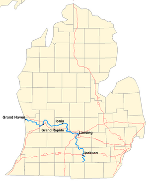
The Grand River is a 252-mile-long (406 km) river in the Lower Peninsula of the U.S. state of Michigan. The longest river in Michigan, the Grand River rises in Hillsdale County, and flows in a generally northwesterly direction to its mouth at Lake Michigan in the city of Grand Haven. The river flows through a number of cities, including Jackson, Lansing, Ionia, and Grand Rapids.

The Sandy River is a 56-mile (90 km) tributary of the Columbia River in northwestern Oregon in the United States. The Sandy joins the Columbia about 14 miles (23 km) upstream of Portland.

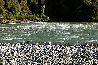
The Buller River is a river in the South Island of New Zealand. The Buller has the highest flow of any river in the country during floods, though it is only the 13th longest river; it runs for 177 km (110 mi) from Lake Rotoiti through the Buller Gorge and into the Tasman Sea near the town of Westport. A saddle at 710 m (2,330 ft) separates the Buller from the Motupiko River and that is divided from the Wairau River by a 695 m (2,280 ft) saddle, both aligned along the Alpine Fault, as is the top of the Buller valley.

Murchison is a town in the Tasman Region of the South Island of New Zealand. It is near the western end of the "Four Rivers Plain", at the confluence of the Buller River and the Mātakitaki River. The other two rivers are the Mangles River, and the Matiri River. It is a rural service town for the surrounding mixed farming district, approximately halfway between Westport and Nelson. Murchison was named after the Scottish geologist Roderick Murchison, one of the founders of the Royal Geographical Society.

The Thompson River is the largest tributary of the Fraser River, flowing through the south-central portion of British Columbia, Canada. The Thompson River has two main branches, the South Thompson River and the North Thompson River. The river is home to several varieties of Pacific salmon and trout. The area's geological history was heavily influenced by glaciation, and the several large glacial lakes have filled the river valley over the last 12,000 years. Archaeological evidence shows human habitation in the watershed dating back at least 8,300 years. The Thompson was named by Fraser River explorer, Simon Fraser, in honour of his friend, Columbia Basin explorer David Thompson. Recreational use of the river includes whitewater rafting and angling.

The Farmington River is a river, 46.7 miles (75.2 km) in length along its main stem, located in northwest Connecticut with major tributaries extending into southwest Massachusetts. The longest route of the river, from the origin of its West Branch, is 80.4 miles (129.4 km) long, making it the Connecticut River's longest tributary by 2.3 miles (3.7 km) over the Westfield River directly to its north. The Farmington River's watershed covers 609 square miles (1,580 km2). Historically, the river played an important role in small-scale manufacturing in towns along its course, but it is now mainly used for recreation and drinking water.

The Buller Gorge is a gorge located in the northwest of the South Island of New Zealand. The Buller River flows through the deep canyon between Murchison and Westport. Land Information New Zealand lists two sections for the gorge, Upper Buller Gorge and Lower Buller Gorge. State Highway 6 runs alongside, but considerably above, the river through the gorge. The Stillwater - Westport Line railway also runs through the gorge.

The Chattooga River is the main tributary of the Tugaloo River.

The Bull Run River is a 21.9-mile (35.2 km) tributary of the Sandy River in the U.S. state of Oregon. Beginning at the lower end of Bull Run Lake in the Cascade Range, it flows generally west through the Bull Run Watershed Management Unit (BRWMU), a restricted area meant to protect the river and its tributaries from contamination. The river, impounded by two artificial storage reservoirs as well as the lake, is the primary source of drinking water for the city of Portland, Oregon.

The Paparoa Range is a mountain range in the West Coast region of New Zealand's South Island. It was the first New Zealand land seen by a European – Abel Tasman in 1642. Part of the range has the country's highest protection as a national park; the Paparoa National Park was established in 1987. Within that park, the Cave Creek disaster occurred in 1995.

The Dead River, sometimes called the West Branch, is a 42.6-mile-long (68.6 km) river in central Maine in the United States. Its source is Flagstaff Lake, where its two main tributaries, South Branch Dead River and North Branch Dead River, join. It flows generally east to join the Kennebec River at The Forks, Maine.

The Hurunui River is the fourth largest of the four principal rivers in north Canterbury, New Zealand, with a catchment area of 2,670 square kilometres (1,030 sq mi). The river flows from the eastern side of the Southern Alps, to the Pacific Ocean.
The Mōkihinui River is a river located on the West Coast of New Zealand's South Island, about 40 kilometres north of Westport. Meridian Energy had proposed the Mokihinui Hydro project on the river in 2007 but it was cancelled in May 2012. In 2019, it was announced that 64,400 ha of land in the Mōkihinui River catchment, including 15 km (9.3 mi) of river bed, would be added to Kahurangi National Park.
The Little Awakino River is a river of North Otago, New Zealand. A tributary of the Waitaki River, it flows into that river a short distance downstream of Lake Waitaki.
The Orikaka River is a river of the West Coast Region of New Zealand's South Island. It flows southwest from the southern end of the Matiri Range before turning south to flow into the Buller River five kilometres to the west of Inangahua.

The Pororari River, with an older spelling of Porarari, is a river of the West Coast Region of New Zealand's South Island. It flows northwest from its sources in the Paparoa Range, reaching the Tasman Sea at Punakaiki via Pororari Lagoon. Cave Creek / Kotihotiho is a tributary to the river. There are opportunities to tramp along this river, with two different options accommodating multi-hour loop walks. Further upstream, the Pororari River is followed by the new Paparoa Track, which provides an opportunity for multi-day tramping or mountain biking.

The Waitaha River is a river of the West Coast region of New Zealand's South Island.

The Wangapeka River is a river of the Tasman Region of New Zealand's South Island. It rises in two branches, the North Branch and the South Branch, in the Matiri Range within Kahurangi National Park, meeting some 25 kilometres southeast of Karamea. It flows generally northeast to reach the Motueka River 30 kilometres south of Motueka.

The West Branch Penobscot River is a 117-mile-long (188 km) tributary of the Penobscot River through the North Maine Woods in Maine. The river is also known as Abocadneticook, Kahgognamock, and Kettegwewick.

The Butler Range, also known as North Butler Range, is a range located in the Westland District of the West Coast Region on the South Island of New Zealand. The range has also been known as Peaks of the Mist Range.


