
Abel Janszoon Tasman was a Dutch seafarer and explorer, best known for his voyages of 1642 and 1644 in the service of the Dutch East India Company (VOC).

Nelson is a New Zealand city on the eastern shores of Tasman Bay at the top of the South Island. It is the oldest city in the South Island and the second-oldest settled city in New Zealand; it was established in 1841 and became a city by royal charter in 1858.

The South Island, also named Te Waipounamu in Māori, is the larger of the two major islands of New Zealand in surface area, the other being the smaller but more populous North Island. It is bordered to the north by Cook Strait, to the west by the Tasman Sea, and to the south and east by the Pacific Ocean. The South Island covers 150,437 square kilometres (58,084 sq mi), making it the world's 12th-largest island, constituting 56% of New Zealand's land area. At low altitude, it has an oceanic climate.

The Tasman Sea is a marginal sea of the South Pacific Ocean, situated between Australia and New Zealand. It measures about 2,000 km (1,200 mi) across and about 2,800 km (1,700 mi) from north to south. The sea was named after the Dutch explorer Abel Janszoon Tasman, who in 1642 was the first known person to cross it. British explorer Lieutenant James Cook later extensively navigated the Tasman Sea in the 1770s during his three voyages of exploration.
Tasman most often refers to Abel Tasman (1603–1659), Dutch explorer.

Tasman District is a local government district in the northwest of the South Island of New Zealand. It borders the Canterbury Region, West Coast Region, Marlborough Region and Nelson City. It is administered by the Tasman District Council, a unitary authority, which sits at Richmond, with community boards serving outlying communities in Motueka and Golden Bay / Mohua. The city of Nelson has its own unitary authority separate from Tasman District, and together they comprise a single region in some contexts, but not for local government functions or resource management (planning) functions.

Abel Tasman National Park is a national park at the north end of New Zealand's South Island. It covers 237.1 km2 (91.5 sq mi) of land between Golden Bay / Mohua and Tasman Bay / Te Tai-o-Aorere, making it the smallest of New Zealand's national parks. Despite this, the park is one of the most visited, partially due to the popularity of the Abel Tasman Coast Track which spans 60 km (37 mi) along the eastern and northern coastal areas of the park.

Haupapa / Tasman Glacier is the largest glacier in New Zealand, and one of several large glaciers which flow south and east towards the Mackenzie Basin from the Southern Alps in New Zealand's South Island.

Tasman Bay, originally known in English as Blind Bay, is a large V-shaped bay at the north end of New Zealand's South Island. Located in the centre of the island's northern coast, it stretches along 120 kilometres (75 mi) of coastline and is 70 kilometres (43 mi) across at its widest point. It is an arm of the Tasman Sea, lying on the western approach to Cook Strait.

The Tasman River is an alpine braided river flowing through Canterbury, in New Zealand's South Island.
Tasman is a former New Zealand parliamentary electorate, from 1972 to 1996.
The Jerry River is a river of the southwestern South Island of New Zealand. It flows northwest into the Gorge River, which flows into the Tasman Sea between Jackson Bay and Big Bay.

The Mahitahi River is a river of the southwest of New Zealand's South Island. It flows northwest from the Hooker Range, part of the Southern Alps, reaching the Tasman Sea at Bruce Bay.
The Stafford River is a river of the West Coast Region of New Zealand's South Island. It flows north, reaching the Tasman Sea 10 kilometres west of the western end of Jackson Bay.

The Waikūkūpa River is a river of the West Coast region of New Zealand's South Island. It flows northwest through Westland Tai Poutini National Park to reach the Tasman Sea 14 kilometres north of Fox Glacier township.
The Whakaikai River is a short river of the West Coast Region of New Zealand's South Island. It flows generally northwest to reach the Tasman Sea five kilometres to the northwest of the mouth of the Wanganui River.

The Whakapohai River is a river of the West Coast Region of New Zealand's South Island. It flows generally northwest to reach the Tasman Sea to the west of Lake Moeraki.
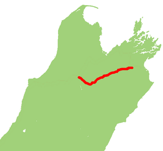
State Highway 63 is a state highway located in the northern parts of the South Island of New Zealand. It is 117 km long and runs between the settlements of Renwick and Kawatiri Junction via Saint Arnaud, providing a bypass of the city of Nelson. Despite being a convenient link between the West Coast and Marlborough, and being a relatively straight highway along most of its length, it is only classified by the NZTA as a secondary collector highway.
Ngāti Tūmatakōkiri is a Māori iwi (tribe) of New Zealand, who arrived on the Kurahaupō waka. In the 1600s the iwi settled northwestern South Island, becoming a major power in the region until the 1800s. In 1642, members of Ngāti Tūmatakōkiri made the first known contact between Europeans and Māori, when Dutch explorer Abel Tasman visited Golden Bay / Mohua.


