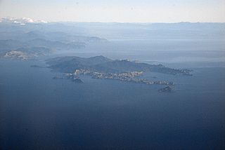
D'Urville Island, Māori name Rangitoto ki te Tonga, is the largest island in the Marlborough Sounds, on the northern coast of the South Island of New Zealand. It was named after the French explorer Jules Dumont d'Urville. With an area of approximately 150 square kilometres (58 sq mi), it is the eighth-largest island of New Zealand, and has around 52 permanent residents. The local authority is the Marlborough District Council.

Nelson is a New Zealand city on the eastern shores of Tasman Bay at the top of the South Island. It is the oldest city in the South Island and the second-oldest settled city in New Zealand; it was established in 1841 and became a city by royal charter in 1858.

Tasman District is a local government district in the northwest of the South Island of New Zealand. It borders the Canterbury Region, West Coast Region, Marlborough Region and Nelson City. It is administered by the Tasman District Council, a unitary authority, which sits at Richmond, with community boards serving outlying communities in Motueka and Golden Bay / Mohua. The city of Nelson has its own unitary authority separate from Tasman District, and together they comprise a single region in some contexts, but not for local government functions or resource management (planning) functions.

Abel Tasman National Park is a national park at the north end of New Zealand's South Island. It covers 237.1 km2 (91.5 sq mi) of land between Golden Bay / Mohua and Tasman Bay / Te Tai-o-Aorere, making it the smallest of New Zealand's national parks. Despite this, the park is one of the most visited, partially due to the popularity of the Abel Tasman Coast Track which spans 60 km (37 mi) along the eastern and northern coastal areas of the park.

Motueka is a town in the South Island of New Zealand, close to the mouth of the Motueka River on the western shore of Tasman Bay. It is the second largest in the Tasman Region, with a population of 8,320 as of June 2023.

Haupapa / Tasman Glacier is the largest glacier in New Zealand, and one of several large glaciers which flow south and east towards the Mackenzie Basin from the Southern Alps in New Zealand's South Island.
The Motueka River is located in the north of the South Island of New Zealand and is a popular tourist destination for watersports and fishing. The Motueka flows 116 kilometres (72 mi) from the mountains 40 km west of the city of Nelson in the southeast of the catchment and flows north to the Tasman Bay.

Riwaka is a small settlement in the Tasman District of New Zealand's South Island. It lies beside Tasman Bay / Te Tai-o-Aorere, five kilometres north of Motueka, and close to the mouth of the Riuwaka River. The land where the town is based was a swamp known as Tureauraki. Europeans first settled in Riwaka in May 1842. The Riwaka economy has been based around growing tobacco and hops.
Tasman Bay, originally known in English as Blind Bay, is a large V-shaped bay at the north end of New Zealand's South Island. Located in the centre of the island's northern coast, it stretches along 120 kilometres (75 mi) of coastline and is 70 kilometres (43 mi) across at its widest point. It is an arm of the Tasman Sea, lying on the western approach to Cook Strait.

Moturoa / Rabbit Island is a small island that lies across the southernmost part of Tasman Bay / Te Tai-o-Aorere, on the northern coast of New Zealand's South Island. The long narrow island runs east–west for 8 kilometres (5 mi), and covers 15 km2 (5.8 sq mi).

Rākauroa / Torrent Bay is a bay in Abel Tasman National Park, New Zealand.
Ngāti Rārua are a Māori tribe of the Tainui tribal confederation.
The Moutere River is a river of the Tasman Region of New Zealand's South Island. It flows north from its origins southwest of Māpua, reaching Tasman Bay / Te Tai-o-Aorere at the Moutere Inlet, a tidal lagoon three kilometres south of Motueka.
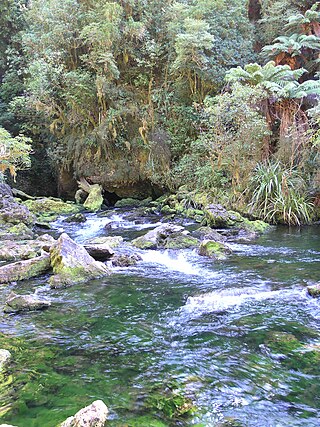
The Pearse River is a river of the Tasman Region of New Zealand's South Island. It flows east from sources in the Wharepapa / Arthur Range, reaching the Motueka River 20 kilometres southwest of Motueka.

Mārahau is a village in the Tasman District of the South Island of New Zealand, approximately 19 kilometres (12 mi) north of Motueka. Its location on Tasman Bay and at the southern entrance of the Abel Tasman National Park makes it a popular holiday destination for those keen on outdoor activities. People access the Abel Tasman from Mārahau by tramping, kayaking and water taxi. In Mārahau itself, the beach offers sheltered and safe swimming, and horse trekking is popular throughout the busy summer season.

State Highway 60 is a state highway servicing the far northwest of the South Island of New Zealand. Running between the settlements of Richmond and Collingwood, it is 116 kilometres (72 mi) long and lies entirely within the Tasman District. It is the northernmost highway in the South Island and is a popular tourist route, servicing Motueka, Abel Tasman National Park, Golden Bay, and Farewell Spit.

Golden Bay is a large shallow bay in New Zealand's Tasman District, near the northern tip of the South Island. An arm of the Tasman Sea, the bay lies northwest of Tasman Bay and Cook Strait. It is protected in the north by Farewell Spit, a 26 km long arm of fine golden sand that is the country's longest sandspit. The Aorere and Tākaka rivers are the major waterways to flow into the bay from the south and the west.
State Highway 61 (SH 61) is a former New Zealand state highway in the Tasman Region of the South Island. It links the coastal town of Motueka with SH 6, the main route to the South Island's West Coast. Along with several other state highways, its status was revoked at the beginning of the 1990s. The route is now usually referred to as the Motueka Valley Highway.

Wainui Bay is within Golden Bay / Mohua, and at the south-eastern end of Golden Bay, in the Tasman Region of the South Island, New Zealand.

The Abel Tasman Monument is a memorial to the first recorded contact between Europeans—led by the Dutch explorer Abel Tasman—and Māori in New Zealand's Golden Bay on 18 and 19 December 1642. It was unveiled on the tercentenary of the encounter by the prime minister, several government ministers, and a Dutch delegation. The monument, originally referred to as the Abel Tasman Memorial, was designed by the architect Ernst Plischke as an abstracted sail, and consists of a large concrete monolith painted white. Located on a bluff at Tarakohe just east of Pōhara, the land for the monument was gifted by the Golden Bay Cement Company. The dignitaries opened the Abel Tasman National Park the following day and the area holding the monument is part of the national park. As was typical for the 1940s, the original inscription focused on the European experience only and overlooked the Māori perspective, demonstrating Western-centric systemic bias. The monument is one of New Zealand's National Memorials.


